Sulphur Springs Cemetery (Sulphur Springs, Arkansas)
|
Sulphur Springs Cemetery | |
 | |
  | |
| Location | Slo Fork Rd., Sulphur Springs, Yell County, Arkansas |
|---|---|
| Coordinates | 35°11′32″N 93°19′31″W / 35.19222°N 93.32528°WCoordinates: 35°11′32″N 93°19′31″W / 35.19222°N 93.32528°W |
| Area | 4.5 acres (1.8 ha) |
| Built | 1844 |
| NRHP Reference # | 12000038[1] |
| Added to NRHP | February 21, 2012 |
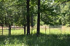
Sulphur Springs Cemetery is a historic cemetery in rural northern Yell County, Arkansas. It is located northwest of Chickalah, on the south side of County Road 39 (Slo Fork Road), about 0.2 miles (0.32 km) west of its junction with County Road 38. The cemetery contains 26 marked burial sites on just over 1 acre (0.40 ha) of the 4.5 acres (1.8 ha) property, dating from 1844 to 1940. There are at least two known unmarked burials, and fieldstones in the cemetery may denote further sites. The cemetery is ringed by a barbed wire fence. It is one of the few surviving remnants of the former spa community of Sulphur Springs, which flourished here in the 19th century.[2]
The cemetery was listed on the National Register of Historic Places in 2012.[1]
See also
References
- 1 2 National Park Service (2010-07-09). "National Register Information System". National Register of Historic Places. National Park Service.
- ↑ "NRHP nomination for Sulphur Springs Cemetery" (PDF). Arkansas Preservation. Retrieved 2016-05-04.
| Topics | |
|---|---|
| Lists by states |
|
| Lists by insular areas | |
| Lists by associated states | |
| Other areas | |
| |