Sulzfluh
| Sulzfluh | |
|---|---|
 Sulzfluh, from the northwest. | |
| Highest point | |
| Elevation | 2,817 m (9,242 ft) |
| Prominence | 475 m (1,558 ft) [1] |
| Parent peak | Drusenfluh |
| Listing | Alpine mountains 2500-2999 m |
| Coordinates | 47°0′45.4″N 9°50′21.7″E / 47.012611°N 9.839361°ECoordinates: 47°0′45.4″N 9°50′21.7″E / 47.012611°N 9.839361°E |
| Geography | |
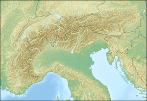 Sulzfluh Location in the Alps | |
| Location |
Graubünden, Switzerland Vorarlberg, Austria |
| Parent range | Rätikon |
| Climbing | |
| First ascent | 1782 |
| Easiest route | Mountain path on eastern face |
The Sulzfluh is a mountain in the Rätikon range of the Alps, located on the border between Austria and Switzerland. The closest locality is St. Antönien, on the southern side.
It is well known by climbers and has a Via ferrata on the southern, Swiss face, in Graubünden. There are a total of six known caves into the limestone mountain, with lengths between 800 and 3000 or more yards, with all entrances on the Eastern side, in Switzerland.[2]
The eastern side has a mountain path of grade T4,[3] allowing non-climbers to reach the 2817 metre summit. This is part of a multi day walking route along the entire length of the Rätikon chain on the sunnier side, called "Prättigauer Höhenweg".[4]
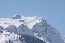
Sulzfluh on the northern (Austrian) side.
References
- ↑ Retrieved from the Swisstopo topographic maps. The key col is the Drusator (2,342 m).
- ↑ Biological report about Cave bear in the caves. (german)
- ↑ (English) Hiking in Switzerland, degree of difficulty
- ↑ (English) Hiking Switzerland past Sulzfluh, Graubünden
External links
| Wikimedia Commons has media related to Sulzfluh. |
This article is issued from Wikipedia - version of the 6/15/2016. The text is available under the Creative Commons Attribution/Share Alike but additional terms may apply for the media files.