Sunderland Center Historic District
|
Sunderland Center Historic District | |
|
Old Town Hall | |
  | |
| Location | Sunderland, Massachusetts |
|---|---|
| Coordinates | 42°28′52″N 73°47′22″W / 42.48111°N 73.78944°WCoordinates: 42°28′52″N 73°47′22″W / 42.48111°N 73.78944°W |
| Architect | Putnam, Karl Scott; Allen Bros. |
| Architectural style | Georgian, Federal |
| NRHP Reference # | [1] |
| Added to NRHP | March 15, 2002 |
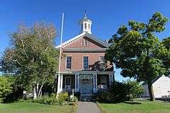
The Sunderland Center Historic District encompasses the historic center of the farming town of Sunderland, Massachusetts, on the plains of the Connecticut River. The -acre district runs along North and South Main Street (Massachusetts Route 47), roughly from Old Amherst Road to North Silver Lane, and includes Bridge Street and the Sunderland Bridge across the river. The properties in the district largely still follow the plan of the town when it was first laid out in 1714. The predominant architectural style in the district is Greek Revival, but there are fine examples of Georgian and Federalist architecture, as well as a number of late 19th and early 20th century architectural styles.[2] The district was listed on the National Register of Historic Places in 2002.[1]
See also
References
- 1 2 National Park Service (2008-04-15). "National Register Information System". National Register of Historic Places. National Park Service.
- ↑ "NRHP nomination for Sunderland Center Historic District". Commonwealth of Massachusetts. Retrieved 2013-12-19.
| Topics |  | ||||||||||||||||||||||||||||||
|---|---|---|---|---|---|---|---|---|---|---|---|---|---|---|---|---|---|---|---|---|---|---|---|---|---|---|---|---|---|---|---|
| Lists by county | |||||||||||||||||||||||||||||||
| Lists by city |
| ||||||||||||||||||||||||||||||
| Other lists | |||||||||||||||||||||||||||||||
| |||||||||||||||||||||||||||||||