Sunset Tunnel
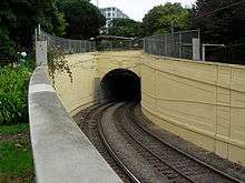 The western portal of the Sunset Tunnel | |
| Overview | |
|---|---|
| Line | |
| Location | San Francisco, California |
| Coordinates |
East portal: 37°46′09″N 122°26′04″W / 37.76917°N 122.43444°W West portal: 37°45′59″N 122°26′55″W / 37.76639°N 122.44861°W |
| System | Muni Metro |
| Start |
Duboce Av. & Noe St. Duboce Park |
| End |
Carl St. & Cole St. Richard Gamble Memorial Park |
| No. of stations | None |
| Operation | |
| Opened | October 21, 1928 |
| Owner | San Francisco Municipal Transportation Agency |
| Operator | San Francisco Municipal Railway |
| Character |
Underground tunnel for light rail/streetcar line |
| Technical | |
| Line length | 4,232 ft (1,290 m; 0.8015 mi) |
| No. of tracks | 2 |
| Track gauge |
4 ft 8 1⁄2 in (1,435 mm) (standard gauge) |
| Electrified | Overhead lines, 600 V DC |
| Tunnel clearance | 23 ft (7.0 m)[1] |
The Sunset Tunnel is a 4,232 ft (1,290 m)-long[1] light rail/streetcar tunnel in San Francisco, California. The tunnel runs under the steep hill adjacent to Buena Vista Park and is used exclusively by the N Judah Muni Metro line.
The tunnel was opened on 21 October 1928 in a ceremony presided over by Mayor James Rolph.[1] The eastern entrance is located at Duboce and Noe streets on the south side of Duboce Park in the Duboce Triangle neighborhood, and the western portal is located in Richard Gamble Memorial Park near the intersection of Carl and Cole streets in the Cole Valley neighborhood.
Access to the tunnel is restricted to San Francisco Municipal Railway light rail trains only. Despite the access limitations, this tunnel is not well protected, and is constantly vandalized and graffiti-strewn. From time to time, automobile drivers manage to drive their cars into the tunnel.[2][3]
See also

References
- 1 2 3 Wallace, Kevin (March 27, 1949). "San Francisco History - City's Tunnels". San Francisco Chronicle. Retrieved July 14, 2008.
- ↑ Terry McSweeney (April 1, 2008). "Drunk drives 2 miles through train tunnel". ABC 7 Local News. Archived from the original on 2012-08-26.
- ↑ Chinn, Jerold (30 September 2016). "Problems persist with drivers attempting to enter Muni tunnels". SFBay.ca. Retrieved 4 October 2016.
| Muni Metro | |
|---|---|
| Muni Metro System features | |
| Heritage streetcar services | |
| Other Muni services | |
| Projects | |
| Connecting services | |
| Agencies and organizations | |
| Museums | |
| Miscellaneous | |
Category | |