Tachylite in Victorian archaeological sites
Tachylite is an unusual and relatively rare stone used in making flaked stone tools, and which is found in Aboriginal archaeological sites in Victoria, Australia.[1] The material is rarely found and apparently is sourced from only one known location at Spring Hill near Lauriston, Victoria.[2][3] There is another historical reference to a source at Green Hill near Trentham, Victoria, but the exact locaiton has not been confirmed. Daniel James Mahony described ...water worn pebbles of pitchstone, a highly silicious volcanic glass associated with tachylite on the Coliban River. Mitchell refers to the distribution of the material with: Small artefacts are common at Willaura, Burrumbeet, Inverleigh, Point Cook and as far north as Dooen near Horsham.[4]
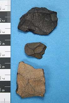
Tachylite is a type of volcanic opaque glass, and is applied to basalts with a glassy matrix that contain scattered small phenocrysts (pyroxene, plagioclase, olivine). Aboriginal artefacts flaked from the material are characterised by a black internal colour, which is very often patinated on the surface to a pale grey. This patina rapidly darkens on contact with the skin, turning as dark as the core. Only a few pieces are generally found in archaeological assemblages in southern Victoria and around Melbourne, apart from at sites near Spring Hill, Kyneton, where it is the most common material.[5][6]
Tachylite artefacts have been noted in Aboriginal sites in Victoria from at least the 1920s, when W. .H Gill recorded its occurrence in a large stone artefact and camp site complex at Cape Liptrap.[7]
Tachylite has also been identified as a material used in manufacturing flaked stone artefacts in archaeological sites in Europe,[8] North America,[9] and India.[10]
Coordinates: 37°18′57″S 144°20′29″E / 37.315704°S 144.341469°E
References
- ↑ A Record In Stone: The Study Of Australia's Flaked Stone Artefacts by Simon Holdaway, Nicola Stern
- ↑ Dr. Ian Nicholls, 'Unusual Newer Volcanics trachyandesite cones in the Gisborne-Woodend and Kyneton-Trentham areas'
- ↑ Willman, C. E., Bibby, L. M., Radojkovic, A. M., Maher, S., Haydon, S. J., Hollis, J. D. and C. R. Osborne, C. R. 2002 Castlemaine. 1:100,000 Map Area Geological Report. Geological Survey of Victoria Report 121. Department of Natural Resources and Environment, Melbourne
- ↑ [Mitchell, S.R. 1949: Stone-Age Craftsmen. Stone Tools and Camping Places of the Australian Aborigines. Tait Book Co. Pty. Ltd. Melbourne. pp.90-91]
- ↑ Clark, V. 2004. Calder Highway Kyneton to Faraday: Sub-surface Archaeological Investigations for Aboriginal Cultural Heritage in Sensitive Areas PAS1, SA1, SA4 and at Site AAV7723-0125, Near Malmsbury, Victoria. Report to VicRoads
- ↑ Clark, V. and Howes, J. 2010. Calder Freeway Faraday to Ravenswood, Harcourt North Section: Archaeological Monitoring During Construction. Report to VicRoads
- ↑ "STONE AGE IN AUSTRALIA.". The Argus. Melbourne: National Library of Australia. 16 April 1921. p. 9. Retrieved 29 August 2013.
- ↑ Local Supply for Chipped Stone Tools from the Site of Rug BairVasilka DIMITROVSKA HAEMUS vil 1 2012, Center for Scientific Research Skopje, Macedonia
- ↑ A Good Place to Hunt, Data Recovery and Site Stabilization at the La VegaSite (LA 9075), Cibola County, New Mexico BY STEPHEN C. LENTZ MUSEUM OF NEW MEXICO OFFICE OF ARCHAEOLOGICAL STUDIES
- ↑ Indian Archaeology 1971-72 a Review, Andhra Pradesh p.11