Tail o' the Pup
| Tail O' the Pup | |
|---|---|
|
A busy day at the Tail O' the Pup in 2005 | |
| General information | |
| Architectural style | Novelty architecture |
| Town or city | Los Angeles, California |
| Country | United States |
| Completed | 1946 |
| Design and construction | |
| Architect | Milton J. Black |
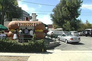
Tail O’ the Pup is an iconic Los Angeles, California hot dog stand actually shaped like a hot dog. Built in 1946, the small, walk-up stand has been noted as a prime example of “mimetic”-type novelty architecture. It was one of the very last surviving mid-20th century buildings that were built in the shapes of the products they sold.[1]
History
Designed by architect Milton Black, the stand opened at La Cienega and Beverly boulevards in June 1946 to luminary-studded, searchlight-lit fanfare. Eddie Blake purchased the Pup in the early 1970s from its celebrity owners, the dance team of Veloz and Yolanda.[2]
Despite its appearance in countless movies, television programs and commercials, the stand faced demolition in the mid-1980s, creating an outcry that resulted in the stand being moved a couple of blocks from its original location at 311 North La Cienega Boulevard to 329 North San Vicente Boulevard.
In December 2005, the Pup was evicted and it moved into a Torrance warehouse after Regent Properties, a development company, purchased the Pup's site from landlord Cedars-Sinai Medical Center, and announced plans to build 152 condominium and apartment units. As of December 2012, construction had not started and the site remained a parking lot.[2]
Owners Dennis and Eddie Blake plan to reopen the Tail O' the Pup once a suitable location is found, possibly in West Hollywood.[2]
The city of Los Angeles has since declared Tail O’ the Pup to be a cultural landmark.
See also
References
- ↑ Betsky, Aaron (July 2, 1992). "Hot Dog Stand Withstands Blitz of Commercialism—With Relish", Los Angeles Times. Retrieved August 26, 2016.
- 1 2 3 Pool, Bob (April 11, 2010), "Quite a Tale for the Pup", Los Angeles Times, retrieved April 13, 2010
External links
- "Tail o' the Pup (profile)". PreserveLA. November 19, 2005.
- Roderick, Kevin (November 9, 2005). "Tail o' the Pup clarified *". LA Observed.
- Jennings, Lisa (January 6, 2006). "Landmark cases in L.A. pit beloved eateries against new development". Nation's Restaurant News.
Coordinates: 34°04′38″N 118°22′47″W / 34.077354°N 118.379773°W