Taleyfac Spanish Bridge
|
Taleyfac Spanish Bridge | |
 | |
 | |
| Location | Off Rte. 2, Agat, Guam |
|---|---|
| Coordinates | 13°21′48″N 144°38′58″E / 13.36333°N 144.64944°ECoordinates: 13°21′48″N 144°38′58″E / 13.36333°N 144.64944°E |
| Area | 0.1 acres (0.040 ha) |
| Architectural style | Spanish stone construction |
| NRHP Reference # | 74002305[1] |
| Added to NRHP | September 10, 1974 |
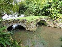
The Taleyfac Spanish Bridge, known locally as Taleyfac Tolai Acho, is a historic stone bridge off Guam Highway 2 in Agat, Guam. It crosses the Taleyfac River with two stone arches; it is 36-foot (11 m) long and 15-foot (4.6 m) wide. It originally had wood timber flooring, which has long ago been replaced. One of the arches has been damaged by the removal or loss by erosion of some of its stones.[2]
The bridge was built between 1866 and the United States' acquisition of Guam in 1898, when Guam was under Spanish colonial administration. It was listed on the National Register of Historic Places in 1974.[1][2]
See also
- National Register of Historic Places listings in Guam
- List of bridges on the National Register of Historic Places in Guam
References
- 1 2 National Park Service (2010-07-09). "National Register Information System". National Register of Historic Places. National Park Service.
- 1 2 David T. Lotz (March 22, 1974). "National Register of Historic Places Inventory/Nomination: Taleyfac Spanish Bridge / Taleyfac Tolai Acho" (PDF). National Park Service. and accompanying photo from 1972
| Topics | |
|---|---|
| Lists by states |
|
| Lists by insular areas | |
| Lists by associated states | |
| Other areas | |
| |
This article is issued from Wikipedia - version of the 11/30/2016. The text is available under the Creative Commons Attribution/Share Alike but additional terms may apply for the media files.