Tao-Rusyr Caldera
| Tao-Rusyr Caldera | |
|---|---|
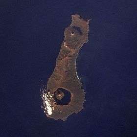 Onekotan Island, with Nemo Peak at top (north) and Tao-Rusyr Caldera at bottom. | |
| Highest point | |
| Elevation | 1,325 m (4,347 ft) |
| Coordinates | 49°21′N 154°42′E / 49.35°N 154.70°E |
| Geography | |
| Location | Onekotan, Kuril Islands, Russia |
| Geology | |
| Mountain type | Stratovolcano / Caldera |
| Last eruption | November 1952 |
Tao-Rusyr Caldera (Russian: Тао-Русыр) is a stratovolcano located at the southern end of Onekotan Island, Kuril Islands, Russia. It has 7.5 km wide caldera formed during a catastrophic eruption less than 10,000 years ago (reported ages range from 5,550 to 9,400 Before Present). The waters of Kal'tsevoe Lake fill the caldera, along with a large symmetrical andesitic cone, Krenitsyn Peak, that rises as an island within the lake. This volcano was named after Captain Pyotr Krenitsyn of the Imperial Russian Navy.
The most recent eruption, in 1952, formed a small lava dome on the island's coast. Krenitsyn Peak has a summit crater 350 m wide and is the highest point of the volcano and on the entire Onekotan Island. Another caldera, Nemo Peak, lies at the northern end of the island, and it also contains a central cone and crater lake.
See also
External links
- "Tao-Rusyr Caldera". Global Volcanism Program. Smithsonian Institution.
- Volcanic Activity and Recent Tephras in the Kuril Islands: Field Result during the International Kuril Island Project (IKIP) 2000