Taourga
| nouader تاورقة Tigisi | |
|---|---|
| Commune and town | |
|
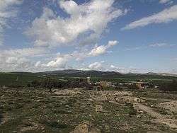
Taourga Area. | |
| Nickname(s): ⵜⵉⵣⵉ ⵏ ⴰⵜⵀ ⴰ̆ⵉⵛⴰ | |
 | |
| Country |
|
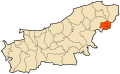
| Province | Boumerdès Province |
| Population (1998) | |
| • Total | 7,303 |
| Time zone | CET (UTC+1) |
Taourga (تاورقة Arabic, Berber ⵜⵉⵣⵉ ⵏ ⴰⵜⵀ ⴰ̆ⵉⵛⴰ en Tifinagh) is a town and commune in Boumerdès Province, Algeria. According to the 1998 census it has a population of 7,303.[1]
Geography
The town is almost mountainous terrain. The town includes the following villages: Beni Attar El Djemaa, Bouhbachou, Boudchicha, Tingrine Ain-El-Kodia, Mazer, Laghdaïr, Wadi Farms and H'lal north on the road to Dellys.
Algeria Post
The ZIP code of Taourga has gone through several stages since the colonial era to the present. Before the administrative division of Algeria in 1984, the Zip code was 15000 But after this, Taourga was attached to the wilaya of Boumerdes bearing number 35. Therefore, the ZIP code of Taourga taken to the generic digital form 351xxx five digits. Finally, the city received Taourga number 0 giving the ZIP code 35140.
But in 2008, at Taourga received a new zip code is 350 294.
Water supplies
This town has several small dams and a seawater desalination plant as well as several boreholes and wells.[2][3] This town is crossed by several wadis:
- Dam Thénia 30 000 m3.
- Dam of El Merdjet Feïat: 50 000 m3.
- Dam of El Allal: 60,000 m3[4]
- Dam Chender: 1700000 m3.[5]
- Dam Djinet: 2800000 m3.[6]
- Dam Sidi Daoud: 3700000 m3[7]
- Beni Amrane Dam: 13.1 million m3.
- Dam Hamiz: 16,280,000 m3.
- Keddara dam Bouzegza: 145,600,000 m3.
- Barrage Oued Djemaa: 176 000 000 M3[8]
The town is serviced by Tala Hydroelectric Power Station Ouranim.[9]
History
In Roman, Vandal and Byzantine times the town was known as Tigisi[10]
The city was incorporated into Islamic empire in the 7th century.
In January 1985, Taourga was raised to the commune level. It had been a village administratively connected to the town of Baghlia, located a dozen kilometers to the west.
Toponymy
The name of the commute is of Berber origin and means "anthill".
Economy
Various types of farms out there. The town is famous for its olive oil, mountain agriculture is practiced. The town is well known for its viticulture producing Cardinal (Red Grape), Dattier grapes, Dabouki (Sabel), Saltana, Muscat grape, Red globe grape, and Victoria grape, as well as Hmar bou Amar and Chasselas grapes.
References
- ↑ "Algeria Municipalities". statoids.com. Retrieved 2016-03-30.
- ↑ http://www.cci-sahel.dz/environnement/env/Monographie.pdf
- ↑ "Les hommes et leurs activités dans la plaine des Issers - Persée". persee.fr. Retrieved 2016-03-30.
- ↑ "Les hommes et leurs activités dans la plaine des Issers - Persée". persee.fr. Retrieved 2016-03-30.
- ↑ "Le Soir d'Algérie". lesoirdalgerie.com. Retrieved 2016-03-30.
- ↑ "Djazairess : Secteur agricole à Boumerdès : Les retenues collinaires sous-exploitées". djazairess.com. Retrieved 2016-03-30.
- ↑ "Wilaya de Boumerdès : le manque d'irrigation freine l'agriculture - AGRO-PASTORALISME". sites.google.com. Retrieved 2016-03-30.
- ↑ "Boumerdes : lancement des travaux d'un barrage au courant de l'année | Algérie 1". algerie1.com. Retrieved 2016-03-30.
- ↑ "Full text of "Recueil des Notices et Memoires de la societe archeologique de la province de constantine"". archive.org. Retrieved 2016-03-30.
- ↑ Procopius. Vandal. ii. 13.
Coordinates: 36°47′38″N 3°56′47″E / 36.79389°N 3.94639°E