Tauț
| Tauț | |
|---|---|
| Commune | |
 Tauț | |
| Coordinates: 46°17′N 21°55′E / 46.283°N 21.917°E | |
| Country |
|
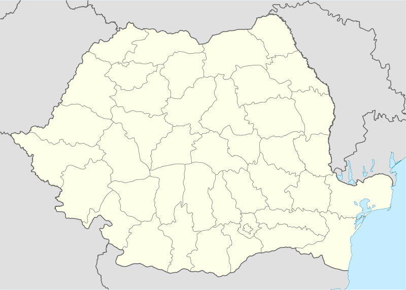
| County | Arad County |
| Population (2002)[1] | 2,177 |
| Time zone | EET (UTC+2) |
| • Summer (DST) | EEST (UTC+3) |
Tauț (Hungarian: Feltót) is a commune in Arad County, Romania.It is situated in the contact zone of the Cigherului Hills and Zărandului Mountains, in the hydrographical basin of the Cigher River. The administrative territory of the commune is 10,617 hectares. It is composed of four villages: Minișel (Alménes), Minișu de Sus (Felménes), Nadăș (Zarándnádas) and Tauț (situated at 55 km from Arad).
Population
According to the last census, the population of the commune counts 2177 inhabitants, out of which 98,7% are Romanians, 0,2% Hungarians, 0,4% Roms, 0,5% Ukrainians and 0,2% are of other or undeclared nationalities.
History
The first documentary record of the locality Tauț dates back to 1496. Minişel, Minişu de Sus and Nadăş. were first mentioned in 1561, 1746, respectively 1464.
Economy
Among the exploitable resources are the diatomite findable in Minișu de Sus. In the last few years tourism and the activities of the tertiary economic sector are showing increasing tendencies in the economic spectrum of the commune.
Tourism
Due to the presence of the Tauț obturator lake it has become one of the most attractive places of the commune. The great investments embarked in the building of summer cottages have started up the development of rural tourism. Another important sight is the mediaeval castle in Tauț surrounded by blindages, dating from the 13-15th centuries.
Coordinates: 46°17′N 21°55′E / 46.283°N 21.917°E
References
- ↑ Romanian census data, 2002; retrieved on March 1, 2010