Telegherry River
| Telegherry River | |
| Right Hand Branch Karuah River[1] | |
| Perennial river | |
 | |
| Country | Australia |
|---|---|
| State | New South Wales |
| Regions | NSW North Coast (IBRA), Mid North Coast, Upper Hunter |
| Local government area | Mid-Coast Council |
| Part of | Mid-Coast Council[2] |
| Source | Williams Range, Great Dividing Range |
| - location | below The Mountaineer, southwest of Gloucester |
| - elevation | 929 m (3,048 ft) |
| Mouth | confluence with the Karuah River |
| - location | north of Dungog |
| - elevation | 157 m (515 ft) |
| Length | 28 km (17 mi) |
| [3] | |
Telegherry River, a perennial river of the Mid-Coast Council[2] system, is located in the Mid North Coast and Upper Hunter regions of New South Wales, Australia.
Course and features
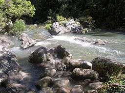
Telegherry River rises on the southeastern slopes of the Williams Range within the Great Dividing Range, below The Mountaineer, southwest of Gloucester, and flows generally south southeast and east, before reaching its confluence with the Karuah River north of Dungog. The river descends 771 metres (2,530 ft) over its 28 kilometres (17 mi) course.[3]
See also
References
- ↑ "Telegherry River". Geographical Names Register (GNR) of NSW. Geographical Names Board of New South Wales. Retrieved 19 March 2013.
- 1 2 "Lakes". Great Lakes Tourism. Great Lakes Council. Retrieved 17 March 2013.
- 1 2 "Map of Telegherry River, NSW". Bonzle Digital Atlas of Australia. Retrieved 19 March 2013.
External links
- "Karuah River and Great Lakes catchments" (map). Office of Environment and Heritage. Government of New South Wales.
River systems and rivers of Hunter-Central Rivers catchment, New South Wales, Australia | |||||||
|---|---|---|---|---|---|---|---|
| |||||||
| |||||||
| |||||||
|
Coordinates: 32°11′S 151°44′E / 32.183°S 151.733°E
This article is issued from Wikipedia - version of the 7/26/2016. The text is available under the Creative Commons Attribution/Share Alike but additional terms may apply for the media files.