Temple Lock
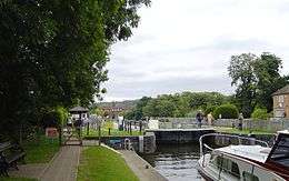

Temple Lock is a lock and weir situated on the Buckinghamshire bank of the River Thames near Temple Mill Island opposite Temple Meadows and not far from Hurley, Berkshire. It was first built by the Thames Navigation Commissioners in 1773.
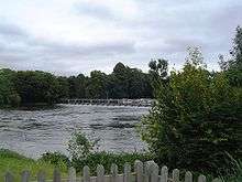
The weir runs across from the lock to the Berkshire bank a short distance upstream of the lock.
History
There are references to a flash lock and winch in the 16th century. There was also a ferry at the lock.
The pound lock was built in 1773, the sixth downstream of the eight constructed after the passing of the 1770 navigation act. Like the others it had to be rebuilt in 1782 and though estimates were obtained for stone and timber, timber was chosen because it was cheaper.
In 1890 a new lock was built alongside the original one.[2]
Access to the lock
The lock is on the Buckinghamshire bank and can only be reached on foot along the towpath from Marlow or Hurley.
Reach above the lock
The reach is one of the shortest on the river with little of note on it. There was formerly a ferry at the top of the lock cut taking the towpath across the river. In 1989 the Temple Footbridge was built across the river at this point to replace the ferry which had ceased operation in 1953.
Thames Path
The Thames Path crosses Temple Footbridge from the Buckinghamshire to Berkshire side. The path then crosses back across footbridges between the islands at Hurley where Hurley lock is located.
See also
| Next lock upstream | River Thames | Next lock downstream |
| Hurley Lock 1.03 km (0.64 mi) [3] |
Temple Lock Grid reference: SU838843 |
Marlow Lock 2.7 km (1.7 mi)[3] |
References
- 1 2 3 "Environment Agency Dimensions of locks on the River Thames". web page. Environmental Agency. 8 November 2012. Retrieved 17 November 2012. Dimensions given in metres
- ↑ Fred. S. Thacker The Thames Highway: Volume II Locks and Weirs 1920 - republished 1968 David & Charles
- 1 2 "Environment Agency Distances between locks on the River Thames". web page. Environmental Agency. 19 November 2012. Retrieved 21 November 2012. Distances given in km
Coordinates: 51°33′08″N 0°47′38″W / 51.5521°N 0.793965°W