Texas State Highway 213
| ||||
|---|---|---|---|---|
 | ||||
| Route information | ||||
| Maintained by TxDOT | ||||
| Length: | 15.293 mi[1] (24.612 km) | |||
| Existed: | by 1935[2] – present | |||
| Major junctions | ||||
| West end: |
| |||
| East end: |
| |||
| Highway system | ||||
| ||||

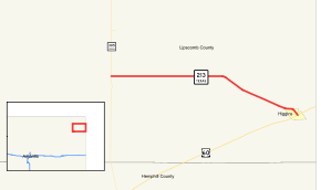
State Highway 213 or SH 213 is a short state highway running from near Lipscomb to Higgins in the eastern Texas Panhandle. The route was conditionally designated along its current route between 1933 and 1935, but had yet to be constructed by 1938.[3]
Junction list
The entire route is in Lipscomb County.
| Location | mi[4] | km | Destinations | Notes | |
|---|---|---|---|---|---|
| | 0.0 | 0.0 | Western terminus | ||
| | 8.0 | 12.9 | |||
| Higgins | 15.2 | 24.5 | Eastern terminus | ||
| 1.000 mi = 1.609 km; 1.000 km = 0.621 mi | |||||
References
- ↑ Transportation Planning and Programming Division (n.d.). "State Highway No. 213". Highway Designation Files. Texas Department of Transportation. Retrieved 2008-04-03.
- ↑ Official Map of the Highway System of Texas (Map). State Highway Commission (Texas Department of Transportation). 1935.
- ↑ Texas Highway Map (Map). Texas State Highway Department (Texas Department of Transportation). 1938.
- ↑ Google (April 29, 2013). "Texas State Highway 213" (Map). Google Maps. Google. Retrieved April 29, 2013.
This article is issued from Wikipedia - version of the 7/31/2016. The text is available under the Creative Commons Attribution/Share Alike but additional terms may apply for the media files.