Texas State Highway 82
| |||||||
|---|---|---|---|---|---|---|---|
 | |||||||
| Route information | |||||||
| Maintained by TxDOT | |||||||
| Length: | 13.01 mi[1] (20.94 km) | ||||||
| Existed: | 1975 – present | ||||||
| Major junctions | |||||||
| South end: |
| ||||||
|
| |||||||
| North end: |
| ||||||
| Location | |||||||
| Counties: | Jefferson | ||||||
| Highway system | |||||||
| |||||||

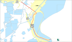
State Highway 82 or SH 82 is a state highway in the U.S. state of Texas that runs 13 miles (21 km) from the Louisiana border as a continuation of Louisiana Highway 82 to Port Arthur. This route was designated in 1975.
History
Pecos, Ward, and Winkler Counties
SH 82 was originally designated by 1926 on a route from the Monahans south to Ft. Stockton, with a planned extension south to Sanderson. By 1928, SH 82 extended north to Kermit. By 1933, SH 82 extended north to the New Mexico Border. The planned extension was transferred to newly designated U.S. Highway 285 in 1935. In 1958, the route was renumbered as SH 18, to coordinate with its intersection with New Mexico State Road 18.
Jefferson County
In 1975, SH 82 was designated over its current route in Jefferson County from SH 87 to Louisiana Highway 82. In 1987, the route was extended 2.1 miles (3.4 km) to SH 73 incorporating the former Texas State Highway Spur 214.
Major junctions
The entire route is in Jefferson County.
| Location | mi | km | Destinations | Notes | |
|---|---|---|---|---|---|
| Sabine River | 0.000 | 0.000 | Southern terminus: Continues into Louisiana | ||
| Port Arthur | |||||
| 13.01 | 20.94 | Northern terminus | |||
| 1.000 mi = 1.609 km; 1.000 km = 0.621 mi | |||||
References
External links
| Wikimedia Commons has media related to Texas State Highway 82. |