Thiers wall
Coordinates: 48°54′00″N 2°20′49″E / 48.89995°N 2.34695°E
.jpeg)
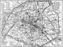
The Thiers wall was the last of the defensive walls of Paris. It was an enclosure constructed between 1841 and 1844 under a law enacted by the government of the French prime minister, Adolphe Thiers. It covered 7,802 hectares (19,280 acres), along the "boulevards des Maréchaux" (Boulevards of the Marshals) of today. A sloping area outside the wall, called a glacis, extended outward from the Thiers wall to the location of today's Boulevard Périphérique. The wall was demolished in stages between 1919 and 1929.
History
Louis-Philippe, proclaimed king of the French in 1830, was convinced that the key to defence of France was to prevent Paris from falling too easily into the hands of foreign armies as happened during the Battle of Paris in 1814. So he conceived the project of building around the city an enclosure of walls that would make the city impregnable.[1]
A first draft was presented to the Chamber of Deputies in early 1833 by Marshal Soult, Council President and Minister of War. It immediately sparked a fierce resistance from the left, whose speakers suspected, or pretended to suspect, that the government had ulterior political motives: that the fortifications were, in fact, designed not to defend France, but to threaten the Parisians in case they come to revolt against the monarchy.
The 33 kilometres (21 mi) long enclosure, colloquially referred to as "the fortress", consisted of 94 bastions, 17 gates (French: "portes", major road crossings), 23 minor road crossings (French: "barrières"), eight railway crossing points, five crossing points of rivers or canals and eight posterns. The only existing remains are the Poterne des Peupliers ("postern of the poplars") between the Porte de Gentilly and Porte d'Italie near where the Bievre entered Paris, bastion number 1 in the middle of the Porte de Bercy interchange, bastion number 45 at the Porte de Clichy, a wall at the Porte de la Villette, part of the Porte d'Arcueil and various smaller remains.[2]
The works were serviced and supplied by the Rue Militaire (military road), supported by a railway line, the Chemin de fer de Petite Ceinture (French for "little belt railway").
The decommissioning of the enclosure
Having become useless due to progress in military technology, the fortifications were demolished, beginning in 1919. Their locations first became vacant lots, often referred to as the "zone". They were progressively rehabilitated from the mid-1920s onward. Later still, the Boulevard Périphérique (Paris ring road) was built on the route of the Thiers wall and continues to separate Paris and its suburbs.
The shape of the former strongholds is marked in several places in the topology of roads into this area. To this day, the strip of land between the current Boulevard Périphérique and the Boulevard des Marechaux, circling all of Paris, can be identified by the building spree of the 1920s and 1930, post the demolition of the wall. The land was used to create new sports facilities and low-income housing, as well as a limited number of more expensive apartment blocks. Many of these upscale buildings were constructed in Art Deco style, which was the dominant architectural style of this era.[3]
The "zone" was not itself the site formerly occupied by the wall, but a strip of land where no building was permitted in front of the wall, a ditch and a slope which measured 250 meters across. It was designated as an area where building was not permitted and it was occupied by slums at the end of the 19th century, with the abandonment of its military function. The French slang "zonard" ("lad" in a pejorative sense) derives from the "zone".[4]
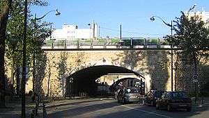 The Poterne des Peupliers ("postern of the poplars") is one of the remains of the Thiers wall
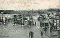 The porte de Pantin, about 1908
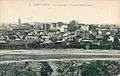 The fortifs zone, in Saint-Ouen
Notes
- ↑ "An 1840 study on the Paris fortifications" (in French). Retrieved 4 October 2009.
- ↑ "La question des fortifications de Paris - 1840" (in French). French government. Retrieved 4 October 2009.
- ↑ http://www.minorsights.com/2016/06/french-art-deco-paris.html
- ↑ Hall, Guy. Les fortifications de Paris (Fortifications of Paris) (in French). éditions Horvath.
References
- Gagneux, Renaud; Denis Prouvost (2004). Sur les traces des enceintes de Paris ("Tracing the old walls of Paris") (in French). Parigramme.
- Hillairet, Jacques. Dictionnaire historique des rues de Paris (Historical Dictionary of Paris streets) (in French).
- le Hallé, Guy (1995). Histoire des fortifications de Paris et leur extension en Île-de-France ("History of the fortifications of Paris and its extension in Ile-de-France) (in French). Éditions Horvath.
- Guy le Hallé, in "Paris aux cent villages", La Ballade des Fortifs, numbers 34 to 45 (in French)
External links
| Wikimedia Commons has media related to Enceinte de Thiers. |
- (French) Paris walls (with a map)
- (French) Guy Le Hallé, The history of "fortifications" (Thiers wall) à Saint-Ouen
- (French) Malakoff Infos, The wall in Malakoff