Thon Buri District
| Thon Buri ธนบุรี | |
|---|---|
| Khet | |
|
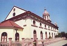
Wat Kanlaya as seen from the river | |
 Khet location in Bangkok | |
| Coordinates: 13°43′30″N 100°29′9″E / 13.72500°N 100.48583°ECoordinates: 13°43′30″N 100°29′9″E / 13.72500°N 100.48583°E | |
| Country | Thailand |
| Province | Bangkok |
| Seat | Bang Yi Ruea |
| Khwaeng | 7 |
| Area | |
| • Total | 8.551 km2 (3.302 sq mi) |
| Population (2003) | |
| • Total | 175,768 |
| • Density | 20,555/km2 (53,240/sq mi) |
| Time zone | ICT (UTC+7) |
| Postal code | 10600 |
| Geocode | 1015 |

Thon Buri (Thai: ธนบุรี; IPA: [tʰōn būrīː]) is one of the 50 districts (khet) of Bangkok, Thailand. On the west bank of Chao Phraya River, it was once part of Thon Buri Province. Neighboring districts are (from north clockwise) Bangkok Yai, Phra Nakhon (across Chao Phraya River), Khlong San, Bang Kho Laem (across Chao Phraya), Rat Burana, Chom Thong, and Phasi Charoen.
History
The district used to be called Amphoe Ratchakhrue (ราชคฤห์) due to a nearby wat of the same name. It was renamed Amphoe Bang Yi Ruea on 11 July 1916 (after the location of the new amphoe office), and finally to Thon Buri on 17 April 1939.[1] The district then belonged to Thon Buri Province. In December 1971 the province was merged with Bangkok to form the present day Bangkok metropolitan area.
Places
- Taksin Monument and Wongwian Yai (วงเวียนใหญ่) (technically the monument lies on Khlong San side of boundary between Thon Buri and Khlong San Districts)
- Santa Cruz Church
- Wat Kanlaya
- Wat Intharam
- Wat Bang Yi Ruea
Shopping
- The Mall Tha Phra
- Big C Israphap
- Robinson Ladya
- Makro Charan Sanitwong
- Merry Kings Wong Wian Yai
- Big C Dao Khanong
Transportation
- Wongwian Yai is a major bus hub on the west side of the Chao Phraya River.
- The district is served by Bangkok Skytrain stations: Pho Nimit, Talad Phlu and Wutthakat. A Bangkok Skytrain Wongwian Yai station lies just outside Thon Buri District into Khlong San District.
Administration
The district is divided into seven sub-districts (kwaeng).
| 1. | Wat Kanlaya | วัดกัลยาณ์ |
| 2. | Hiran Ruchi | หิรัญรูจี |
| 3. | Bang Yi Ruea | บางยี่เรือ |
| 4. | Bukkhalo | บุคคโล |
| 5. | Talat Phlu | ตลาดพลู |
| 6. | Dao Khanong | ดาวคะนอง |
| 7. | Samre | สำเหร่ |
References
- ↑ พระราชกฤษฎีกาเปลี่ยนนามอำเภอ กิ่งอำเภอ และตำบลบางแห่ง พุทธศักราช ๒๔๘๒ (PDF). Royal Gazette (in Thai). 56 (0 ก): 354–364. April 17, 1939.
.svg.png)