Thorner
| Thorner | |
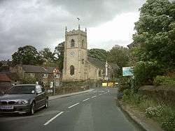 Thorner Church |
|
 Thorner |
|
| Population | 1,646 (2011) |
|---|---|
| OS grid reference | SE3798040610 |
| Civil parish | Thorner |
| Metropolitan borough | City of Leeds |
| Metropolitan county | West Yorkshire |
| Region | Yorkshire and the Humber |
| Country | England |
| Sovereign state | United Kingdom |
| Post town | LEEDS |
| Postcode district | LS14 |
| Dialling code | 0113 |
| Police | West Yorkshire |
| Fire | West Yorkshire |
| Ambulance | Yorkshire |
| EU Parliament | Yorkshire and the Humber |
| UK Parliament | Elmet |
Coordinates: 53°51′37″N 1°25′26″W / 53.860329°N 1.424020°W
Thorner is a rural village and civil parish in the City of Leeds in West Yorkshire, England, located between Seacroft and Wetherby. It has a population of 1,503,[1] increasing to 1,646 at the 2011 Census.[2]
History
.jpg)
The village appears in the 1086 Domesday Book as "Torneure" (also "Tornoure") means "thorn bank". The ancient parish of Thorner covered 4400 acres in the wapentake of Skyrack in the West Riding of Yorkshire.[3] The parish included the townships of Scarcroft and Shadwell, which became separate civil parishes in 1866.[4]
The church of St Peter is built in the later English gothic style and has a square embattled tower In the graveyard is the grave of John Philips, who lived to 118 years. A school was built by subscription in 1787. The Wesleyan Methodists have a place of worship in the village.[3]
Geography
Thorner is situated close to the A1, A58 and A64 trunk roads. It is 8 miles (13 km) north-east of Leeds city centre and 7 miles (11 km) to the south-west of Wetherby. The underlying rock is limestone, some of which was burnt into lime and flagstone and slates were quarried.[3]
Travel to and from the village by public transport is via the 770 bus route (operated by the Transdev Harrogate & District bus company). The journey takes roughly half an hour from Leeds, 20 minutes from Wetherby and an hour from Harrogate.
Features
Thorner has no street lighting. The village has two public houses, the Mexborough Arms and The Fox. There is a Post Office, village shop and a restaurant, formerly The Beehive pub, the Victory Hall, a bowling green, and cricket and football pitches
 Mexborough Arms
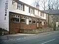 The Beehive
 The Fox
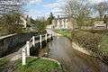 Thorner ford
References
- ↑ Office for National Statistics : Census 2001 : Parish Headcounts : Leeds Retrieved 2009-09-10
- ↑ "Civil Parish population 2011". Neighbourhood Statistics. Office for National Statistics. Retrieved 29 February 2016.
- 1 2 3 Lewis, Samuel (1848), "Thorner St Peter", A Topographical Dictionary of England, British History Online, pp. 331–335, retrieved 2011-01-16
- ↑ Vision of Britain website
External links
- Thorner Parish Council web page
- Thorner Village Website
- "The Ancient Parish of Thorner". GENUKI. Retrieved 2007-10-29.