Thornton, Leicestershire
Coordinates: 52°40′N 1°19′W / 52.66°N 01.31°W
Thornton is a village in Leicestershire, England. The village is within the civil parish of Bagworth and Thornton (where the population is included). It is a linear village lying along a scarp overlooking Thornton Reservoir.
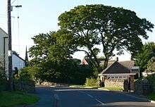
photographed in July 2007
The Church of England parish church of St Peter was built in the 13th century. The church door was originally at Ulverscroft Priory. It was reported in November 2011 that the church is being split in two by subsidence.[1]
From 1832 until 1871 Thornton was served by Merry Lees railway station on the Leicester and Swannington Railway.
Thornton Reservoir has an area of 75 acres (30 ha). It is no longer used as a source of drinking water. Severn Trent Water opened it to the public in 1997. Nearby is Brown's Wood, formerly Manor Farm Woodland, which was planted in part due to the heavy metal group Iron Maiden liaising with The Carbon Neutral Company to plant enough saplings to offset the carbon dioxide generated by the production and distribution of their 2003 CD Dance of Death.[2] There is a club here and a pub (The Bricklayers Arms). It was originally a farming and mining village, but the mine was closed in February 1984.
Notable residents
- Lemuel Abbott was vicar here.
References
| Wikimedia Commons has media related to Thornton, Leicestershire. |
 |
Ellistown | Stanton under Bardon | Markfield | |
| Bagworth | |
Ratby | ||
| ||||
| | ||||
| Newbold Heath | Merry Lees | Botcheston |