Tikipunga
| Tikipunga | |
|---|---|
 Whangarei Falls | |
| Basic information | |
| Local authority | Whangarei |
| Population | 5,931 (2013) |
| Surrounds | |
| Northeast | Glenbervie |
| South | Otangarei |
| Southwest | Te Whau |
| West | Kamo |
| Northwest | Springs Flat |
Tikipunga is one of the biggest suburbs in Whangarei, New Zealand. It is in the north-east part of the town and has the landmark Whangarei Falls nearby.
The population was 5,931 in the 2013 Census, an decrease of 183 from 2006.[1]
Whangarei Falls
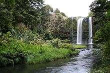
At Whangarei Falls, the Hātea River drops 26 metres (85 ft) over a basalt lava flow. There are walkways around the falls and along the river. The falls were originally known as Otuihau, and have been a picnic spot since at least the 1890s. In the 1920s, the land was bought by Archibald Clapham (of Clapham's Clocks) to prevent commercial exploitation of the falls. The Whangarei Businessmen's Association raised funds in 1946 to buy the land on behalf of the citizens of the town.[2]
Education
Tikipunga High School is a state coeducational Year 7-13 secondary school on Corks Road, with a roll of 309 students as of July 2016.[3] The school opened in 1971, and its current principal is Alec Solomon.
Tikipunga Primary School is a contributing primary (years 1-6) school with a roll of 212.[4]
Te Kura Kaupapa Maori o Te Rawhiti Roa is a composite (years 1-15) school with a roll of 199.[5]
All these schools are coeducational. Tikipunga High School and Primary School have a decile rating of 2. Te Kura Kaupapa Maori o Te Rawhiti Roa has a decile of 1.
.jpg) Whangarei Falls as seen from a walkway over the river.
Whangarei Falls as seen from a walkway over the river.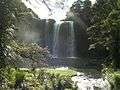 Falls from below.
Amenities
The Paramount Plaza shopping centre on Paramount Parade serves the suburb and is anchored by a large Countdown Supermarket. It contains a service station, several food outlets, a liquor store, a pharmacy, a video store and a medical centre. Nearby the plaza is the Tikipunga branch of the Whangarei Libraries. There is also a smaller suburban shopping strip on the corner of Kiripaka and Spedding roads.
Notes
- ↑ The population shown is the combined population of Tikipunga East (Quickstats about Tikipunga East) and Tikipunga West (Quickstats about Tikipunga West).
- ↑ Parkes, W. F. (1992). Guide to Whangarei City and District. p. 11. ISBN 0-473-01639-7.
- ↑ "Directory of Schools - as at 2 August 2016". New Zealand Ministry of Education. Retrieved 2016-08-16.
- ↑ Te Kete Ipurangi schools database: Tikipunga Primary School
- ↑ Te Kete Ipurangi schools database: Te Kura Kaupapa Maori o Te Rawhiti Roa
External links
35°41′06″S 174°19′43″E / 35.684873°S 174.328543°ECoordinates: 35°41′06″S 174°19′43″E / 35.684873°S 174.328543°E