Tionesta Creek
| Tionesta Creek | |
| Stream | |
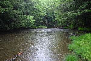 The Tionesta Creek, deep in the Allegheny National Forest. | |
| Country | United States |
|---|---|
| State | Pennsylvania |
| Counties | Warren, McKean, Elk, Clarion, Forest |
| Source | |
| - location | Sheffield, Warren County, Pennsylvania |
| - elevation | 1,925 ft (587 m) [1] |
| - coordinates | 41°40′36″N 79°2′4″W / 41.67667°N 79.03444°W [2] |
| Mouth | Allegheny River |
| - location | Tionesta, Forest County, Pennsylvania |
| - elevation | 1,046 ft (319 m) [1] |
| - coordinates | 41°29′15″N 79°27′24″W / 41.48750°N 79.45667°WCoordinates: 41°29′15″N 79°27′24″W / 41.48750°N 79.45667°W [2] |
| Length | 61.9 mi (100 km) [1] |
| Basin | 480 sq mi (1,243 km2) [1] |
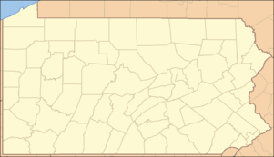 Location of the mouth of Tionesta Creek in Pennsylvania | |
Tionesta Creek is a tributary of the Allegheny River in Forest, Clarion, Warren, McKean, and Elk Counties in Pennsylvania in the United States. Together with its West Branch, Tionesta Creek is 61.9 miles (99.6 km) long, flows generally south, and its watershed is 480 square miles (1,243 km2) in area.
See also
References
- 1 2 3 4 Shaw, L. C.; W. F. Busch (June 1984). Pennsylvania Gazetteer of Streams, Part II. Water Resources Bulletin. 16. Prepared in Cooperation with the United States Department of the Interior Geological Survey. Harrisburg, PA: Pennsylvania Department of Forest and Waters. p. 267. OCLC 17150333.
- 1 2 "Tionesta Creek". Geographic Names Information System. 2008. Retrieved 2008-08-14.
External links
This article is issued from Wikipedia - version of the 9/11/2016. The text is available under the Creative Commons Attribution/Share Alike but additional terms may apply for the media files.