Tipton County, Tennessee
| Tipton County, Tennessee | |
|---|---|
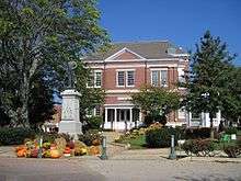 Tipton County Courthouse in Covington | |
|
Location in the U.S. state of Tennessee | |
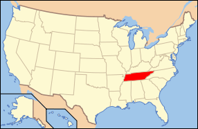 Tennessee's location in the U.S. | |
| Founded | Oct. 29, 1823 |
| Named for | Jacob Tipton, 18th-century soldier[1] |
| Seat | Covington |
| Largest city | Covington |
| Area | |
| • Total | 473 sq mi (1,225 km2) |
| • Land | 458 sq mi (1,186 km2) |
| • Water | 15 sq mi (39 km2), 3.2% |
| Population (est.) | |
| • (2010) | 61,870 |
| • Density | 133/sq mi (51/km²) |
| Congressional district | 8th |
| Time zone | Central: UTC-6/-5 |
| Website |
www |
Tipton County is a county located on the western end of the U.S. state of Tennessee, in the Mississippi Delta region. As of the 2010 census, the population was 61,081.[2] Its county seat is Covington.[3]
Tipton County is part of the Memphis, TN–MS–AR Metropolitan Statistical Area.
History
Indian cultures
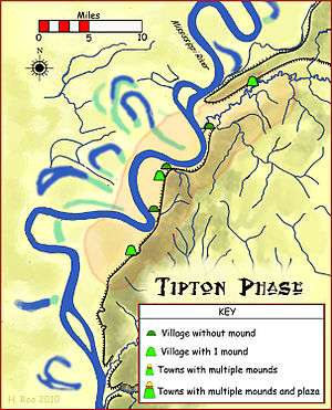
From about 10,000 BCE, Paleo-Indians and later Archaic-Indians lived as communities of hunter-gatherers in the area that covers the modern day southern United States.[4][5] From approximately 800 CE to 1600 CE, the Mississippi Delta was populated by tribes of the Mississippian culture, a mound-building Native American people who had developed in the late Woodland Indian period.[5][6] While there were chiefdoms and centers along the Mississippi and its tributaries, their major center was at Cahokia, in present-day Illinois east of St. Louis, Missouri.
The Tipton Phase people were a local expression of the Mississippian culture. They still inhabited the region of modern-day Tipton County during the time of first contact with Europeans, at the arrival of the Spanish Hernando de Soto Expedition. By the end of the Mississippian period, the land was claimed and populated by the Chickasaw tribe.[7] The exact origins of the Chickasaw are uncertain.[8]
Around 1800, Europeans began settling the Chickasaw-inhabited lands east of the Mississippi River. Chickasaw land in what became known as West Tennessee and southwestern Kentucky was ceded in the Jackson Purchase. Both states grew considerably as a result of this purchase.[9] In 1818, both sides agreed to the transfer by signing the Treaty of Tuscaloosa.[10] The Chickasaw were to be paid annuities for 15 years, but the United States was often late with payment, or forced the people to take the value in goods. These were often delayed or were of poor quality.
1811 and 1812 earthquakes
Due to topographic changes caused by the New Madrid earthquakes in 1811 and 1812, part of what is now Tipton County was cut off from the state of Tennessee by a change in the course of the Mississippi River. The earthquake changed the course of the river near the settlement of Reverie, Tennessee. The old riverbed is west of Reverie. The river now runs east of Reverie, putting Reverie on the Arkansas side, while most of the area of Tipton County is located east of the river, on the Tennessee side.[11]
Establishment
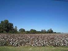
Tipton County attracted European-American settlers who established cotton plantations on its fertile soils and either brought or purchased enslaved African Americans as field labor and house servants. This area was part of the cotton culture associated with the Mississippi Delta, that extended down to the Yazoo River in Mississippi. With the increase in population, the county was established on October 29, 1823 from parts of Shelby County, which borders Tipton County in the south. The land was former Chickasaw Indian territory. The county was named for Jacob Tipton (1765–1791), father of Armistead Blevins, who supervised the organization of Shelby County. Tipton was killed by Native Americans in 1791 in a conflict over the Northwest Territory.[1] Jacob Tipton was the son of John Tipton, a rival of John Sevier during Tennessee's State of Franklin period.[12]
19th century
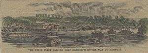
Early Mississippi River steamboat commerce flourished in Tipton County. In 1830, the community of Randolph, one of the earliest settlements in Tipton County, was the most important shipping point in Tennessee and an early rival of Memphis for commercial supremacy. But its fortunes declined in later years.[13] Riverboat traffic gradually yielded to freight being shipped by railroad. The first rail service in Tipton County was established in December 1855, when the Memphis and Ohio Railroad completed the route from Memphis to Nashville, running through what is now Mason.
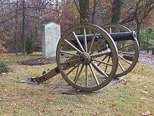
Two Civil War forts, Fort Randolph and Fort Wright, were built near the settlement because of its strategic location on the second Chickasaw Bluff of the Mississippi River.[14][15]
Following the Civil War, investment in infrastructure was renewed, and the Memphis and Paducah Railroad completed the tracks to Covington in July 1873. A telegraph line between Memphis and Covington was opened in 1882. In 1894, Covington was connected to electricity. Forced water mains have provided residents of Covington with water since 1898. In 1922, street paving began in the county seat. Since 1929, residents of Covington have had access to natural gas.[16]
In the South Main Historic District in Covington, about 50 residences from the late 19th century and the early 20th century are still intact.[16] The district is listed on the National Register of Historic Places.
Geography
According to the U.S. Census Bureau, the county has a total area of 473 square miles (1,230 km2), of which 458 square miles (1,190 km2) is land and 15 square miles (39 km2) (3.2%) is water.[17]
The major north-south route, U.S. Highway 51, bisects Tipton County into a western half and eastern half, and passes through Covington. The western boundary of Tipton County is the Mississippi River, where Tennessee meets Arkansas; however, in several places where the river's course was altered by the 1812 New Madrid earthquake, the boundary still follows the old alignment of the river, with the result that a few of Tipton County's communities — including Reverie and Corona — are now located on the Arkansas side, rather than the Tennessee side, of the river.
Tipton County is situated on the southeastern edge of the New Madrid Seismic Zone, an area with a high earthquake risk.
Adjacent counties
- Lauderdale County (north)
- Haywood County (east)
- Fayette County (southeast)
- Shelby County (south)
- Crittenden County, Arkansas (southwest)
- Mississippi County, Arkansas (northwest)
Demographics
| Historical population | |||
|---|---|---|---|
| Census | Pop. | %± | |
| 1830 | 5,317 | — | |
| 1840 | 6,800 | 27.9% | |
| 1850 | 8,887 | 30.7% | |
| 1860 | 10,705 | 20.5% | |
| 1870 | 14,884 | 39.0% | |
| 1880 | 21,033 | 41.3% | |
| 1890 | 24,271 | 15.4% | |
| 1900 | 29,273 | 20.6% | |
| 1910 | 29,459 | 0.6% | |
| 1920 | 30,258 | 2.7% | |
| 1930 | 27,498 | −9.1% | |
| 1940 | 28,036 | 2.0% | |
| 1950 | 29,782 | 6.2% | |
| 1960 | 28,564 | −4.1% | |
| 1970 | 28,001 | −2.0% | |
| 1980 | 32,930 | 17.6% | |
| 1990 | 37,568 | 14.1% | |
| 2000 | 51,271 | 36.5% | |
| 2010 | 61,081 | 19.1% | |
| Est. 2015 | 61,870 | [18] | 1.3% |
| U.S. Decennial Census[19] 1790-1960[20] 1900-1990[21] 1990-2000[22] 2010-2014[2] | |||
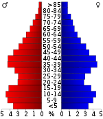
As of the census[24] of 2000, there were 51,271 people, 18,106 households, and 14,176 families residing in the county. The population density was 112 people per square mile (43/km²). There were 19,064 housing units at an average density of 42 per square mile (16/km²). The racial makeup of the county was 77.86% White, 19.90% Black or African American, 0.38% Native American, 0.37% Asian, 0.06% Pacific Islander, 0.38% from other races, and 1.04% from two or more races. 1.21% of the population were Hispanic or Latino of any race. By 2005 1.6% of the county's population was Latino.
There were 18,106 households out of which 39.60% had children under the age of 18 living with them, 60.20% were married couples living together, 13.90% had a female householder with no husband present, and 21.70% were non-families. 18.70% of all households were made up of individuals and 7.40% had someone living alone who was 65 years of age or older. The average household size was 2.78 and the average family size was 3.17.
In the county, the population was spread out with 29.30% under the age of 18, 8.60% from 18 to 24, 30.40% from 25 to 44, 21.80% from 45 to 64, and 9.90% who were 65 years of age or older. The median age was 34 years. For every 100 females there were 97.00 males. For every 100 females age 18 and over, there were 93.20 males.
The median income for a household in the county was $41,856, and the median income for a family was $46,807. Males had a median income of $35,611 versus $23,559 for females. The per capita income for the county was $17,952. About 10.30% of families and 12.10% of the population were below the poverty line, including 16.30% of those under age 18 and 17.70% of those age 65 or over.
In 2006, according to the U.S. Census Bureau population estimate, 57,380 people resided in 22,551 housing units in Tipton County. In comparison to a population of 51,271 in the year 2000, the county population increased by 11.9% in six years. 50.7% of the population in 2006 was female, 49.3% was male. Of the population in 2006, 79.2% were White, 18.8% were Black, .4% were of Native American or Alaska Native race and 1.6% were of another ethnicity.[25]
Parks and recreation
Tipton County Museum
The Tipton County Museum is located in Covington. The museum houses various history exhibits featuring artifacts from Tipton County's rich heritage and a nature center depicting the unique ecosystem of West Tennessee. Taxidermies of local species and mastodon bone fragments give insight into the natural history. Adjacent to the museum, a 20-acre (8.1 ha) park with a .5-mile (800 m) walking trail can be found. Natural woodland and man-made wetlands are the sites for a few smaller local species, such as turtles and birds. The Veterans Memorial in front of the museum commemorates the soldiers from the county who lost their lives in wars.[16][26]
County parks
The county's parks include:[16]
- Atoka Community Park houses four softball fields. It was built in 1992.
- Court Square Park is a city park with fountains and brick dedication walls.
- Frazier Park is a 10-acre (4.0 ha) park with a .5-mile (800 m) fitness trail, playgrounds and ballfields.
- Munford City Park hosts independence festivities every year.
- Patriot Park opened in 2004; its centerpiece is an A-4 Skyhawk attack bomber.
- Poplar Park offers a covered picnic area, ball fields and a playground.
- Shelton Park is a 1-acre (0.40 ha) landscaped garden park with gazebo and picnic tables.
- Valentine Regional Park is a family park with picnic pavilion and playgrounds.
Communities
Cities
Towns
Unincorporated communities
See also
References
- 1 2 Angela Wallace Finley, "Tipton County," Tennessee Encyclopedia of History and Culture, 2009. Retrieved: 9 February 2013.
- 1 2 "State & County QuickFacts". United States Census Bureau. Retrieved December 7, 2013.
- ↑ "Find a County". National Association of Counties. Retrieved 2011-06-07.
- ↑ Guy Prentice (2003). "Pushmataha, Choctaw Indian Chief". Southeast Chronicles. Retrieved 2008-02-11.
- 1 2 Smith, Gerald P. (1996). "The Mississippi River Drainage of Western Tennessee". In Charles H. McNutt. Prehistory of the Central Mississippi Valley. University of Alabama Press. pp. 97–118. ISBN 0-8173-0807-5.
- ↑ "History & Archaeology: Mississippian Period: Overview". The New Georgia Encyclopedia. 2002-10-03. Retrieved 10 December 2008.
- ↑ Smith, Gerald P. (1990). "The Walls Phase and its Neighbors". In David H. Dye and Sheryl Ann Cox. Towns and Temples Along the Mississippi. University of Alabama Press. pp. 135–169. ISBN 0-8173-0455-X.
- ↑ Cushman, Horatio (1899). "Choctaw, Chickasaw, and Natchez". History of the Choctaw, Chickasaw and Natchez Indians. Norman, Oklahoma: University of Oklahoma Press. pp. 18–19. ISBN 0-8061-3127-6.
- ↑ "Jackson Purchase". excerpt from The Kentucky Encyclopedia edited by John E. Kleber. 1992. Archived from the original on 2008-10-06. Retrieved 2008-10-24.
- ↑ "Treaties". Tennessee Encyclopedia of History and Culture. Retrieved 9 February 2013.
- ↑ http://www.tnhistoryforkids.org/local/tipton www.tnhistoryforkids.org
- ↑ Colonel John Tipton: Sons. Retrieved: 18 April 2013.
- ↑ Tennessee Historical Markers (8th ed.). Tennessee Historical Commission. 1996. ISBN 0-87402-021-2.
- ↑ "TN Encyclopedia: Fort Wright". The Tennessee Encyclopedia of History and Culture. Retrieved 9 February 2013.
- ↑ Foote, A. H. (March 5, 1862). "The Evacuation of Columbus. The Town Reduced to a Heap of Ruins by the Rebels. Their Retreat to Fort Randolph (...) - (Dispatch from Flag-Officer Foote)" (PDF). The New York Times. Retrieved 10 January 2009.
- 1 2 3 4 Covington-Tipton County Community Guide. Covington, Tennessee: Tipton County Chamber of Commerce. 2005.
- ↑ "2010 Census Gazetteer Files". United States Census Bureau. August 22, 2012. Retrieved April 14, 2015.
- ↑ "County Totals Dataset: Population, Population Change and Estimated Components of Population Change: April 1, 2010 to July 1, 2015". Retrieved July 2, 2016.
- ↑ "U.S. Decennial Census". United States Census Bureau. Retrieved April 14, 2015.
- ↑ "Historical Census Browser". University of Virginia Library. Retrieved April 14, 2015.
- ↑ Forstall, Richard L., ed. (March 27, 1995). "Population of Counties by Decennial Census: 1900 to 1990". United States Census Bureau. Retrieved April 14, 2015.
- ↑ "Census 2000 PHC-T-4. Ranking Tables for Counties: 1990 and 2000" (PDF). United States Census Bureau. April 2, 2001. Retrieved April 14, 2015.
- ↑ Based on 2000 census data
- ↑ "American FactFinder". United States Census Bureau. Retrieved 2011-05-14.
- ↑ "Tipton County QuickFacts from the U.S. Census Bureau". U.S. Census Bureau. Retrieved 2008-10-04.
- ↑ "Tipton County Museum". Tipton County. Archived from the original on June 14, 2007. Retrieved 2008-10-04.
External links
| Wikimedia Commons has media related to Tipton County, Tennessee. |
- Official site
- Covington-Tipton County Chamber of Commerce
- Tipton County Schools
- TNGenWeb
- Tipton County at DMOZ
 |
Mississippi County, Arkansas | Lauderdale County | | |
| |
Haywood County | |||
| ||||
| | ||||
| Crittenden County, Arkansas | Shelby County | Fayette County |
Municipalities and communities of Tipton County, Tennessee, United States | ||
|---|---|---|
| Cities | ||
| Towns | ||
| Unincorporated communities | ||


Nashville (capital) | |
| Topics | |
| Grand Divisions | |
| Regions | |
| Largest cities | |
| Counties |
|
Coordinates: 35°29′N 89°46′W / 35.49°N 89.76°W