Tishomingo State Park
| Tishomingo State Park | |
| Mississippi State Park | |
 Bridge over Bear Creek in Tishomingo State Park | |
| Country | United States |
|---|---|
| State | Mississippi |
| County | Tishomingo |
| Elevation | 515 ft (157 m) [1] |
| Coordinates | 34°36′18″N 88°11′25″W / 34.60500°N 88.19028°WCoordinates: 34°36′18″N 88°11′25″W / 34.60500°N 88.19028°W [1] |
| Area | 1,530 acres (619 ha) [2] |
| Established | 1930s |
| Management | Mississippi Department of Wildlife, Fisheries and Parks |
 Location in Mississippi | |
| Website: Tishomingo State Park | |
|
Tishomingo State Park | |
|
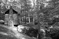
Cabin located within the park | |
  | |
| Nearest city | Tishomingo, Mississippi |
| Area | 590 acres (240 ha) |
| Built | 1936 |
| Architectural style | Other, Rustic |
| MPS | State Parks in Mississippi built by the CCC MPS |
| NRHP Reference # | 98000275[3] |
| Added to NRHP | March 26, 1998 |
Tishomingo State Park is located in the foothills of the Appalachian Mountains in Tishomingo County, Mississippi, northeast of Tupelo. The major feature of the park is Bear Creek Canyon and its generous outcrops of Hartselle Sandstone. The boulders and towering cliffs of this rock, together with the outcrops of Bangor Limestone and the creek which carves through it all, compose "some of the most picturesque and rugged scenery in the state."[4] Activities in the park include canoeing, rock climbing, fishing, and hiking.[5]
Geography
The park pays tribute to Tishomingo County's remarkable geography of massive rock formations, found here and in the immediately surrounding areas but nowhere else in Mississippi.[6] The cliffs, valleys and abundant outcroppings of carboniferous sandstone and limestone represent the southwestern extremity of the Southern Appalachian Plateau.[6]
Indigenous History
The park is named for one of the last great Chickasaw leaders, Chief Tishu Miko, born not far from here in Lee County, Mississippi, around 1735.[7] Modern Chickasaw occasionally make pilgrimage to the park to visit the areas where the famous Chief fished and hunted.[8]
Chief Tishomingo (the modern form of his name) served a brilliant career in the US Military, distinguishing himself in such actions as the Battle of Fallen Timbers, the Red Stick Rebellion and the War of 1812. His influence became powerful and extended into Washington, DC. He was a principal signatory to a number of important treaties, including the Treaty of Pontotoc in 1832 (negotiated at great length with Andrew Jackson but never ratified by the Senate). His most momentous and perhaps most difficult signature was put to the 1837 Treaty of Doaksville, which he affirmed only under heavy political pressure. This document, in large part a lease agreement with the Choctaw Nation,[9] incidentally compelled the removal of the last Chickasaw from this area to the Indian Territory in Oklahoma.[10] It is believed that, in May 1838, Chief Tishomingo succumbed to smallpox at the advanced age of 104, near Little Rock on the Trail of Tears. His burial site is unknown.
The park's importance to Native American history extends even beyond the historical Chickasaw Nation, as archaeological excavations confirm the presence of Paleo Indians in the area now encompassed by the park as early as 7000 B.C.[5] The ancient tribes were able to produce excellent tools from the high-quality chert and limestone that was available here, and ceramic pottery from clay dug from the hills. A small museum located in the park office houses a collection of artifacts from various periods of Native American occupation.[11]
Park History
The park was constructed by the Civilian Conservation Corps during the 1930s. Many of the original facilities are extant, including several buildings, trails, picnic tables, campgrounds, cabins and even a fishing pond used by the CCC workers themselves.
CCC construction of the Mississippi State Park system began on May 29, 1934, when a camp was established at the area which would become Leroy Percy State Park near Hollandale in the Mississippi Delta. By July of the following year, nine parks were under construction in the state, including Tishomingo State Park. Most of the facilities in Mississippi were built of wood. Only Tishomingo and Wall Doxey State Parks feature substantial use of stone construction. The rustic quality of the structures resulted from the use of native materials, the original designs, and the craftsmanship of the builders.[12]
Many of the park's facilities, including trails, were refurbished in 1997 by the service organization Americorps.[11]
Attractions
Tishomingo State Park offers visitors seven hiking trails that range in length from ¾ to 3 miles and in difficulty from easy to moderate.[13] The trails feature beautiful scenery, including natural springs, waterfalls, rocky creeks and streams, cliffs, rock walls and huge outcrops.[14] The terrain suggests mountains, and indeed this is a part of the Appalachian range, but the hills here are no higher than about 660 feet.[8] Rock climbing, which requires a helmet and a free permit (available at the park office), is a popular activity on the trails, particularly at the formation known as Jean's Overhang.[15] Bear Creek is encountered at a number of points by the trail system, and can itself be explored by canoe on one of the float trips offered here.
Three popular disc golf courses are available, and an Olympic-sized outdoor swimming pool is open during late spring and summer. The park provides a number of lodging options including primitive and improved tent campsites, full RV hookups and furnished cabins.
The Natchez Trace Parkway, a scenic road operated by the National Park Service and commemorating the historical Natchez Trace, runs directly through the park.[16]
Gallery
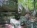 Outcroppings at Tishomingo State Park
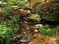 Stream passing by cabin in the park
 Swinging Bridge crossing Bear Creek
References
- 1 2 "Tishomingo State Park". Geographic Names Information System. United States Geological Survey.
- ↑ "Tishomingo State Park". OutdoorPlaces.com.
- ↑ National Park Service (2010-07-09). "National Register Information System". National Register of Historic Places. National Park Service.
- ↑ Bulletin: Mississippi State Geological Survey, Issues 12 & 13. Mississippi Geological, Economic and Topographical Survey. 1915. p. 54. Retrieved 24 Nov 2012.
- 1 2 "Tishomingo State Park". Parks and Destinations. Mississippi Department of Wildlife, Fisheries, and Parks. Retrieved July 18, 2014.
- 1 2 A.F. Crider; L.C. Johnson (1906). "Summary of the Underground-Water Resources of Mississippi". Congressional Edition. United States Congress, U.S. Government Printing Office. p. 156. Retrieved 19 Jan 2012.
- ↑ "Chief Tishomingo". Chickasaw Nation Hall of Fame. The Chicakasaw Nation. Retrieved 31 Oct 2012.
- 1 2 Morris, M. Scott (September 25, 2011). "Find your fun at Tishomingo State Park". The Daily Journal. Tupelo, Miss. Retrieved 10 Nov 2012.
- ↑ Oklahoma Historical Society retrieved 12 Nov 2012
- ↑ "History". The Chickasaw Nation. Retrieved July 13, 2014.
- 1 2 National Geographic Guide to the State Parks of the United States of America, 3rd Ed, retrieved 20 Nov 2012.
- ↑ Todd Sanders, Review and Compliance Assistant (August 15, 1996). "State Parks in Mississippi built by the CCC between 1934 - 1942" (PDF). NPS Form 10-900-b. National Park Service. Retrieved July 13, 2014.
- ↑ "Hiking Trails: Tishomingo State Park" (PDF). Mississippi Department of Wildlife, Fisheries, and Parks. Retrieved 23 Oct 2011.
- ↑ Clark, JB (August 6, 2012). "Tishomingo State Park offers climbing, canoeing, hiking". The Daily Journal. Tupelo, Miss. Retrieved 10 Nov 2012.
- ↑ "Tishomingo State Park Hiking Trails". Mississippi Hills National Heritage Area. Retrieved 31 Oct 2012.
- ↑ "Official Mississippi Highway Map" (PDF). Mississippi Department of Transportation. 2012. Retrieved 25 Nov 2012.
|section=ignored (help)
External links
| Wikimedia Commons has media related to Tishomingo State Park. |
- Tishomingo State Park Mississippi Department of Wildlife, Fisheries, and Parks
| Topics | |
|---|---|
| Lists by states |
|
| Lists by insular areas | |
| Lists by associated states | |
| Other areas | |
| |