Tom Davies Square
| Tom Davies Square Place Tom Davies (French) | |
|---|---|
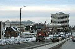 Tom Davies Square is the complex of grey buildings visible behind the Sudbury Theatre Centre facility. | |
| General information | |
| Architectural style | Modernist |
| Location | Sudbury, Ontario, Canada |
| Address | 200 Brady Street |
| Owner | City of Greater Sudbury |
| Design and construction | |
| Architect | Arthur Townend[1] |
| Architecture firm | Townend, Stefura, Baleshta and Nicholls |
Tom Davies Square (French Place Tom-Davies) is the city hall of Greater Sudbury, Ontario.
Built in the late 1970s and originally known as Civic Square or 'Place-Civique' in French, the building was part of an urban renewal movement toward transforming the city's visual image by investing in modern architecture.[2] The square consists of a triangular main building with its right angle facing the corner of Brady and Paris Streets and a glass-walled hypoteneuse facing onto an outdoor plaza in the centre of the complex. This building contains the city hall proper, its administrative offices and the city council chambers. A diamond-shaped second building located to the west once contained the Sudbury Public School Board and the Sudbury Public Library's Archives branch. It now houses the headquarters of the Greater Sudbury Police Service. Another similar shaped but taller building housing provincial government offices was added to the northeast corner of the site several years later.[2] Completing the square is a fourth building in similar materials, built in a rectangular shape with modern colonnade breezeway, housing Bell offices.
Prior to the completion of the current facility, the former city hall was so overcrowded that the civic administration was operating out of several different downtown office buildings, and council meetings had to be held in the auditorium of the Sudbury Public Library's Mackenzie branch.[2]
The facility was renamed in 1997 in honour of Tom Davies, the retiring chairman of the Regional Municipality of Sudbury.
References
- ↑ "Arthur Townend, Architect 1924-2005". The Globe and Mail, September 9, 2005.
- 1 2 3 C.M. Wallace and Ashley Thomson, Sudbury: Rail Town to Regional Capital. Dundurn Press, 1993. ISBN 1-55002-170-2.
Coordinates: 46°29′25″N 80°59′25″W / 46.49021°N 80.99018°W