Tomari Station (Toyama)
Tomari Station 泊駅 | |
|---|---|
 The station exterior in December 2015 | |
| Location |
631 Kawahara, Hiranayagi, Asahi-machi, Shimoniikawa-gun, Toyama-ken 939-0744 Japan |
| Operated by | Ainokaze Toyama Railway |
| Line(s) | ■■ Ainokaze Toyama Railway Line |
| Train operators | |
| Other information | |
| Website |
ainokaze |
| History | |
| Opened | 16 April 1910 |
Tomari Station (泊駅 Tomari-eki) is a railway station on the Ainokaze Toyama Railway Line in Asahi, Toyama, Japan, operated by the third-sector railway operator Ainokaze Toyama Railway.
Lines
Tomari Station is served by the Ainokaze Toyama Railway Line. Many through services from the neighbouring Echigo Tokimeki Railway Nihonkai Hisui Line terminate at Tomari, with both Echigo Tokimeki Railway trains and Ainokaze Toyama Railway trains using platform 2 to provide a same-platform transfer.[1]
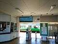 The entrance to the platforms in December 2015
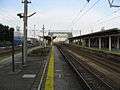 The station platforms in February 2010
 An Ainokaze Toyama Railway 521 series EMU and an Echigo Tokimeki Railway ET122 diesel unit at Tomari Station in June 2015
 A passenger information sign on platform 2 indicating the locations for boarding Ainokaze Toyama Railway and Echigo Tokimeki Railway trains
Adjacent stations
| « | Service | » | ||
|---|---|---|---|---|
| Ainokaze Toyama Railway Line | ||||
| Nyūzen | Local | Etchū-Miyazaki | ||
History

The station opened on 16 April 1910.[2] With the privatization of Japanese National Railways (JNR) on 1 April 1987, the station came under the control of JR West.[2]
From 14 March 2015, with the opening of the Hokuriku Shinkansen extension from Nagano to Kanazawa, local passenger operations over sections of the Hokuriku Main Line running roughly parallel to the new shinkansen line were reassigned to different third-sector railway operating companies.[1] From this date, Tomari Station was transferred to the ownership of the Ainokaze Toyama Railway.[1]
See also
References
- 1 2 3 Osano, Kagetoshi (March 2015). 北陸新幹線並行在来線各社の姿 [Guide to companies operating conventional lines alongside the Hokuriku Shinkansen]. Tetsudō Daiya Jōhō Magazine (in Japanese). Vol. 44 no. 371. Japan: Kōtsū Shimbun. pp. 28–33.
- 1 2 Ishino, Tetsu, ed. (1998). 停車場変遷大辞典 国鉄・JR編 [Station Transition Directory - JNR/JR]. II. Japan: JTB. p. 141. ISBN 4-533-02980-9.
External links
| Wikimedia Commons has media related to Tomari Station (Toyama). |
- Ainokaze Toyama Railway station information (Japanese)
Coordinates: 36°57′07″N 137°33′21″E / 36.95194°N 137.55583°E