Tomaszów Mazowiecki
| Tomaszów Mazowiecki | |||
|---|---|---|---|
|
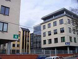
Modern buildings | |||
| |||
 Tomaszów Mazowiecki | |||
| Coordinates: 51°31′N 20°1′E / 51.517°N 20.017°E | |||
| Country |
| ||
| Voivodeship | Łódź | ||
| County | Tomaszów Mazowiecki County | ||
| Gmina | Tomaszów Mazowiecki (urban gmina) | ||
| Established | 18th century | ||
| Town rights | 1830 | ||
| Government | |||
| • Mayor | Marcin Witko | ||
| Area | |||
| • Total | 41.3 km2 (15.9 sq mi) | ||
| Population (2006) | |||
| • Total | 66,705 | ||
| • Density | 1,600/km2 (4,200/sq mi) | ||
| Time zone | CET (UTC+1) | ||
| • Summer (DST) | CEST (UTC+2) | ||
| Postal code | 97-200 | ||
| Area code(s) | +48 44 | ||
| Car plates | ETM | ||
| Website | http://www.tomaszow-maz.eu | ||

Tomaszów Mazowiecki pronounced [ tɔˈmaʂuf mazɔˈvjɛt͡ski ] is a town in central Poland with 67,159 inhabitants (2004). Situated in the Łódź Voivodeship (since 1999), it was previously part of Piotrków Trybunalski Voivodeship (1975–1998). Tomaszów occupies an area of 41.3 square kilometres (15.9 sq mi) as of 2002.
The town is situated on the banks of three rivers, the Pilica, Wolbórka, and Czarna Bielina, and is near the Zalew Sulejowski reservoir and the edge of the Puszcza Spalska wilderness area.
History
Tomaszów Mazowiecki was granted the status of an industry and trade settlement (osada fabryczno-handlowa) in 1824, and was designated a city in 1830 during the November Uprising in Congress Poland against the Russian Empire. A year later the Jewish Qahal was founded.[1]
The Holocaust
By 1931 the Jewish population of the city grew to 11,310 inhabitants, or about 30% of the general population of Tomaszów.[1] During the Nazi-Soviet invasion of Poland of 1939 the city was overrun by Nazi Germany. Next month the Great Synagogue was burned to the ground as first on 16 October 1939; the remaining two synagogues were destroyed on 7–14 November.[1] The Ghetto for the imprisonment of 16,500 Polish Jews was created in December 1940, and closed off from the outside in December 1941. Hunger was rampant, followed by the typhus epidemic. In December 1942 some 15,000 Jews were deported aboard Holocaust trains to Treblinka extermination camp. Some 200 Jews from Tomaszów are known to have survived World War II.[1]
Land usage
According to data from 2006, Tomaszów Mazowiecki has an area of 41.3 km2; about 45% of the land is put to agricultural use, 13% is forested, and the city itself covers about 4.03% of the area.
Education
- I High School im. Jaroslawa Dabrowskiego at Mościckiego Street
- II High School im. Stefana Zeromskiego at Jalowcowa Street
- III High School im. Stanislawa Hojnowskiego at Nadrzeczna Street
- IV High School at Strefowa Street
- Branch of University of Łódź
Transportation
Several national and regional routes cross each other in the city:
 (planned
  ) direction Suwałki – Warszawa – Tomaszów Mazowiecki – Wrocław – Kudowa-Zdrój
 direction Kozienice – Dęblin – Kock
 direction Łódź – Tomaszów Mazowiecki – Januszewice koło Opoczna
Sulejów Landscape Park

In the valley of the Pilica river in the south-eastern part of the town there is a unique natural karst spring of water containing calcium salts, that is an object of protection in Niebieskie Źródła Nature Reserve in Sulejów Landscape Park. The origin of the name of the reserve Niebieskie Źródła, that means Blue Springs, comes from the fact that red waves are absorbed by water and only blue and green are reflected from the bottom of the spring, giving that atypical colour.[2] The reserve in situated near the end of Saint Anthony Street (in Polish: ulica świętego Antoniego) that begins in the centre of Tomaszów Mazowiecki, in proximity to the central square, called Kościuszko Square (in Polish: plac Kościuszki).
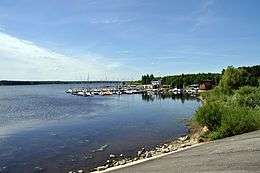
Zalew Sulejowski
The Zalew Sulejowski is a large reservoir built from 1969–1973 in order to help meet the demand for fresh drinking water in the city of Łódź and the city of Tomaszów Mazowiecki. The actual reservoir is situated on the territory of three gminas: Tomaszów, Piotrków and Wolbórz. It is popular place for water sports, including windsurfing, kayaking and sailing.
Konewka Bunkers
The Konewka Bunkers is a complex of various technical and headquarters buildings, among which is a large bunker capable of protecting a train from an air raid, normally serving as a station to unload the cargo of the train.
International relations
Twin towns — Sister cities
Tomaszów Mazowiecki is twinned with:
 Mionica, Serbia
 Prato, Italy
 Ivano-Frankivsk, Ukraine[3]
 Linares, Spain
 Polonezköy, Turkey
Notes
- 1 2 3 4 Fronczkowski M. (2015). "History of Tomaszów Mazowiecki". "Tomaszowscy Żydzi", Towarzystwo Przyjaciół Tomaszowa Mazowieckiego. Muzeum Historii Żydów Polskich POLIN. Retrieved 19 April 2015.
- ↑ http://www.touristlink.com/poland/blue-springs-of-tomaszow-mazowiecki/overview.html
- ↑ "Офіційний сайт міста Івано-Франківська" (in Ukrainian). mvk.if.ua. Retrieved 7 March 2010.
References
| Wikimedia Commons has media related to Tomaszów Mazowiecki. |
Coordinates: 51°32′N 20°01′E / 51.533°N 20.017°E
| Seat |
| _COA.svg.png) |
|---|---|---|
| Rural gminas | ||