Tomlinson Lift Bridge
| Tomlinson Lift Bridge | |
|---|---|
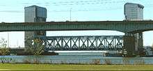 Tomlinson Bridge from Criscuolo Park, New Haven, just beyond the original Q Bridge of Interstate 95. | |
| Coordinates | 41°17′54″N 72°54′19″W / 41.298296°N 72.905292°WCoordinates: 41°17′54″N 72°54′19″W / 41.298296°N 72.905292°W |
| Carries |
four lanes of |
| Crosses | Quinnipiac River |
| Locale | New Haven, New Haven County, Connecticut, United States |
| Owner | ConnDOT[1] |
| Characteristics | |
| Design | Vertical-lift bridge[1] |
| Material | steel[1] |
| Total length | 283.5 metres (930 ft)[1] |
| Width | 28 metres (92 ft)[1] |
| Longest span | 82.3 metres (270 ft)[1] |
| History | |
| Designer | Hardesty & Hanover, LLP[1] |
| Engineering design by | Nicholas J. Altebrando, Thomas A. Duffy, Michael D. Hawkins, Timothy J. Noles[1] |
| Construction begin | 1922[2] |
| Construction end | 1797,[3] 1885,[3] 1924,[2] 2002[1] |
| Construction cost | USD$125,000,000[1] |
 Tomlinson Lift Bridge Location in Connecticut | |
The Tomlinson Lift Bridge is a crossing of the Quinnipiac River in New Haven, Connecticut. The bridge forms a segment of U.S. Route 1. The Tomlinson Vertical Lift Bridge carries four lanes of traffic across New Haven Harbor and a single-track freight line owned by the Providence & Worcester Railroad that connects the waterfront with the Northeast Corridor line of Metro North and CSX. A sidewalk is present along the southern edge of the bridge.
History
The first bridge here was erected in 1797 by Isaac Tomlinson's group to replace profits from their ferry ruined by a new bridge.[3] This 27-foot (8.2 m)-wide covered wooden truss bridge included a draw to allow vessels through.[3] It has also been described as a "wood and sandstone" bridge.[4]
The second bridge, 1885-1922, was an iron bridge which was never particularly good, having been salvaged from a scrap yard, and not thought well of even before then.[3] By 1913, this bridge was opening 17,000 times a year.[5] Plans for replacement were created during World War I.[5]
The third bridge on-site was a trunioned double-leaf bascule drawbridge with its counterweights in a closed pit underneath, built between 1921 and 1924.[5] It was designed by engineer Ernest W. Wiggin of New Haven in the Beaux-Arts style, based on a bascule design by Joseph B. Strauss.[5][6] Before the completion of the adjacent Q Bridge, it was carrying 30,000 vehicles a day.[7] When closed, clearance under the bridge was 12 feet (3.7 m) at mean high water, ranging from 8–17 feet (2.4–5.2 m) at extreme high tide to extreme low tide.[7] The channel width was 117 feet (36 m), with a total span length between centers of 148 feet (45 m).[7] The builder was the Phoenix Bridge Company of Philadelphia, Pennsylvania.[8]
The current bridge, the fourth one on this site, is a lift bridge 270 feet (82 m) long and 92 feet (28 m) wide, a significant improvement from the previous (third) bridge's 117-foot (36 m) channel.[4] The mechanism raises the lift span 62 feet (19 m) with 3,000,000-pound (1,400,000 kg) counterweights on each of the two 150-foot (46 m) towers on either end.[4] The bridge cost $120 million, designed by Hardesty & Hanover LLP of New York City, is 90 feet (27 m) wide and 270 feet (82 m) long with two 30-foot (9.1 m) tower spans and six 100-foot (30 m)-long approach spans.[9] The lift span weighs almost 6,500,000 pounds (2,900,000 kg) with a total load-to-move of 13,000,000 pounds (5,900,000 kg). It provides a channel with 240 feet (73 m) horizontal clearance and 13 feet (4.0 m) vertical clearance when the span is closed, and an additional 62 feet (19 m) vertical clearance when it is open.
The project began as a renovation of the third Tomlinson Bridge but evolved into the construction of a totally new structure. Securing the bridge's lift piers initially proved difficult because rock elevation and slope differed along the route. To secure the piers, teeth were welded to the tip of 20-in-diameter pile shells that were then drilled into the bedrock. For some piles, an adequate seal was not achieved until the pile had been seated into 5 ft. of bedrock.
Oblique railroad crossing controversy
Recent controversy has erupted over the danger posed to area cyclists by the railroad tracks on the eastern approach to the bridge. Because the tracks cross Route 1 at an oblique angle, bicycle tires are frequently ensnared in the gap (known as a "flangeway") between the steel rails and the surrounding rail bed material. New Haven has one of the most active bicycling communities in New England. For cyclists traveling to and from New Haven along the coast from points east, the Tomlinson Bridge is the only direct crossing available. In fact, the road is designated as the State of Connecticut's primary recommended "cross state" bicycling route,[10] and as a city bicycle route by the New Haven City Plan office,.[11]
Several bicycle injuries have been documented at this crossing.[12]
Local bicycle advocates, including members of ElmCityCycling, have urged city and Connecticut Department of Transportation officials to take action to prevent further injuries at the crossing. To date, signs have been posted warning cyclists of the crossing, but injuries persist. Cyclists have commented on the limited visibility of the signs.
Two approaches to reducing bicycle falls are 1) routing of cyclists via a bicycle lane so that they intersect the tracks at a 90-degree angle[13] and 2) installation of rubberized flange fillers between the rails and surrounding rail bed material which compress under the wheels of the train.[14] The latter remedy is prescribed in the ConnDOT Bicycle Design Manual:
"On low-speed, lightly traveled railroad tracks, commercially available flange way fillers can eliminate the gap next to the rail. The filler normally fills the gap between the inside railbed and the rail. When a train wheel rolls over it, the flange way filler compresses. This solution, however, is not acceptable for high-speed rail lines, as the filler will not compress fast enough and the train may derail.[15]"
Despite this ConnDOT recommendation and the fact that Providence and Worcester trains cross Route 1 infrequently and at very low speeds, in an October 2009 working group between city, state, and railroad officials, the railroad rejected the use of flange fillers, citing the risk of derailment as well as the expense of maintaining the fillers in a northern climate.
During July and August, 2010, two meetings were convened between ECC advocates and officials from CDOT, the P&W Railroad, the New Haven Port Authority, and the Federal Railroad Administration. A number of interventions at the grade crossing were discussed. CDOT agreed to mitigate risks in the short term, during which time the area around the crossing would serve as a staging area for construction of the new I-95 Quinnipiac Bridge. CDOT agreed to repave the pitted, degraded asphalt around the tracks, a job which appeared to be complete as of Aug 20, 2010. Additionally, CDOT agreed to fill the flangeways with stone dust, to be removed in the event that a P&W train needed access to the New Haven Harbor. For a longer term remedy, CDOT proposed removing an eastbound vehicle lane on the bridge and replacing it with 6' bicycle lanes at the far edge of the eastbound and westbound travel lanes. Additionally, although the P&W railroad argued that flange fillers could become impregnated with ice during the winter, changing their mechanical properties and causing derailment, CDOT agreed to perform additional research into the suitability of flange fillers for the crossing. Cycling advocates noted the success of products such as the veloStrail[16] in reducing cyclist injury elsewhere in the world, including places with cold climates.
In July, 2011, CDOT added shared lane markings ("sharrows") to both the east and westbound lanes. In the eastbound lane, the sharrow guides cyclists into a bicycle lane that curves so as to intersect the rails at a 90-degree angle. In the westbound lane, the sharrow directs cyclists into a dismount area, allowing them to cross the rails on foot. CDOT also added additional signage showing bicycles wheels lodging in the rail flange way, though cyclists have pointed out that the signs appear close to the crossing, allowing cyclists very little time to react before reaching the rails.
CDOT also announced in July, 2011 that it will test flange fillers at the crossing sometime during the summer of 2011. In the meantime, the flange way is to be filled with stone dust.
Lack of "Complete Streets" design
The State of Connecticut and City of New Haven have each passed significant legislation regarding complete streets, requiring the accommodation of all road users, especially on bridges like the Tomlinson that serve as crucial connections between different neighborhoods.[17] Though the bridge as a whole was not designed using any "Complete Streets" principles in part because it was built prior to this legislation, many local residents have called for improvements to pedestrian and cyclist accommodations on the roadway. In its current configuration, the wide road lanes encourage travel well in excess of the posted speed limit, which negatively impacts the comfort level of road users. A sidewalk is only present on one side of the bridge, and narrows dramatically at one point, requiring pedestrians to walk within just a few feet of passing traffic. There are no accommodations specifically for bicycles.
See also
-
 Bridges portal
 -
 Connecticut portal
 - List of bridges documented by the Historic American Engineering Record in Connecticut
- List of movable bridges in Connecticut
References
- 1 2 3 4 5 6 7 8 9 10 11 Tomlinson Lift Bridge at Structurae
- 1 2 HAER data page 2
- 1 2 3 4 5 HAER data page 4
- 1 2 3 "Cianbro Bridges Quinnipiac River". Construction Equipment Guide. Retrieved 16 January 2015.
- 1 2 3 4 HAER data page 5
- ↑ HAER data page 7
- 1 2 3 HAER data page 6
- ↑ HAER data page 13
- ↑ Tomlinson bridge construction notes
- ↑ http://www.ct.gov/dot/cwp/view.asp?a=1390&q=292876 State of CT Bicycle Routes
- ↑ http://www.cityofnewhaven.com/cityplan/pdfs/EnvironmentalInitiatives/Greenways/BikeMap_Front.pdf City of New Haven Designated Bicycle Routes
- ↑ The following bicycle injuries have been documented at this railroad crossing: (1) June 26, 2010: Two cyclists fall on tracks during the annual New Haven Century. One of them breaks his femur; (2) September 26, 2009: Two cyclists fall and are injured while riding during a Yale Cycling event; (3) September 25, 2009: A cyclist falls during an evening group ride over the tracks, and suffers minor injuries; (4) September 13, 2009: A cyclist falls after his wheels become stuck in the tracks; (5) August 30, 2009: A cyclist is involved in a hit-and-run incident on the bridge and severely injures his arm and shoulder; (6) June 24, 2009: A cyclist falls on tracks while biking to Lighthouse Point and fractures her wrist; (7) August 2008: A cyclist crashes on the bridge, due to a passing car, and breaks his elbow; (8) August, 2007: A cyclist falls on tracks and seriously injures his left shoulder rotator cuff. Continued: July 5, 2010 - a Yale professor falls on the tracks and suffers minor injuries. July 17, 2010 - a woman falls on the tracks and breaks her pelvis.
- ↑ Oregon DOT Bicycle Design Guidelines, pp. 6-7
- ↑ VT Agency of Transportation Pedetrian and Bicycle Facility Planning and Design, p. 4-32
- ↑ ConnDOT Bicycle Design Guidelines, page 42
- ↑ http://www.strail.de/index.php?id=197&L=1 veloStrail
- ↑ "Design New Haven: Complete Streets Legislation Passes New Haven Board of Aldermen: Next Stop Hartford".
External links
- New Haven Register article July 6, 2009
- SeeClickFix issue on Tomlinson Bridge
- YouTube video of cyclist falling on tracks
- New Haven Independent coverage of cycling injuries on the Tomlinson Bridge
- Design New Haven coverage of efforts to eliminate the rail crossing hazard
- New Haven Independent: Cyclists protest signage in favor of more reliable solution
- New Haven Register: Cyclists protest lack of action on tracks
- New Haven Register: Further coverage, July 21, 2010
- New Haven Register Editorial calls for swift action at the tracks, Aug 9, 2010
- New Haven Register says tracks "remain an obstacle", Sept 7, 2010
- Historic American Engineering Record (HAER) No. CT-61, "Tomlinson Bridge, Spanning Quinnipiac River at Forbes Street (U.S. Route 1), New Haven, New Haven County, CT", 46 photos, 36 data pages, 6 photo caption pages