Torne River Railway Bridge
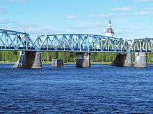
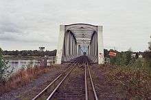
The Torne River Railway Bridge is a dual gauge railway bridge between Haparanda, Sweden and Tornio, Finland; the 1524mm rails used for Finland, the 1435mm rails used for Sweden.[1] A temporary ice river track was built over the Torne River in 1917.[2] The current bridge was opened in 1919 and was the first direct connection between the towns until the road bridge opened in 1939. It was jointly built by the governments of Sweden and Finland, and by the railway.[3]

The bridge is painted white from the Finnish side to the international border, and is blue from there to the Swedish side. The dual gauge tracks continue over the bridge into railway marshalling yard in either country (a Swedish-gauge marshalling yard in Tornio, and a Finnish-gauge yard in Haparanda). Passenger trains also went over the bridge but have been withdrawn; the Norwegian Railways ended passenger traffic to the Swedish side gradually between 1984 and 1988 while the last SJ passenger train left Haparanda in 1992. A train between Boden, Sweden and Haparanda was tried in the early 2000s, but was stopped as it was unprofitable. As of 2014, Green Cargo is shunting in Tornio, usually once or twice a day on weekdays and Saturdays. VR will shunt in Haparanda, if necessary. Current cross-border traffic consists of containerized goods and freight from Outokumpu. Cross-border freight transport is expected to increase on the Swedish side with construction of the new railway line between Kalix and Haparanda.[2]
Technical details
The bridge is 245m long, and was built as a swing bridge (although it was seldom-used as such) which rotated in the horizontal plane around the central pillar. The bridge was converted to a fixed structure on October 22, 1985.[4]
References
- ↑ "The Lyngenfjord Highway – 1939". www.alternativefinland.com. Retrieved April 14, 2014.
- 1 2 "Tornio–Haaparanta". www.resiinalehti.fi (in Finnish). Resiina. Retrieved April 27, 2014.
- ↑ "HAAPARANTAAN ENNEN VANHAAN". http://arkisto.fi (in Finnish). Oulu County Archive, Finland. 2014. Retrieved April 14, 2014. External link in
|website=(help) - ↑ Haparandabanan, Järnvägsdata med trafikplatser 2009 (in Swedish). Svenska Järnvägsklubben. 2009. ISBN 91-85195-05-7.
Coordinates: 65°49′40″N 24°08′58″E / 65.8278°N 24.1495°E