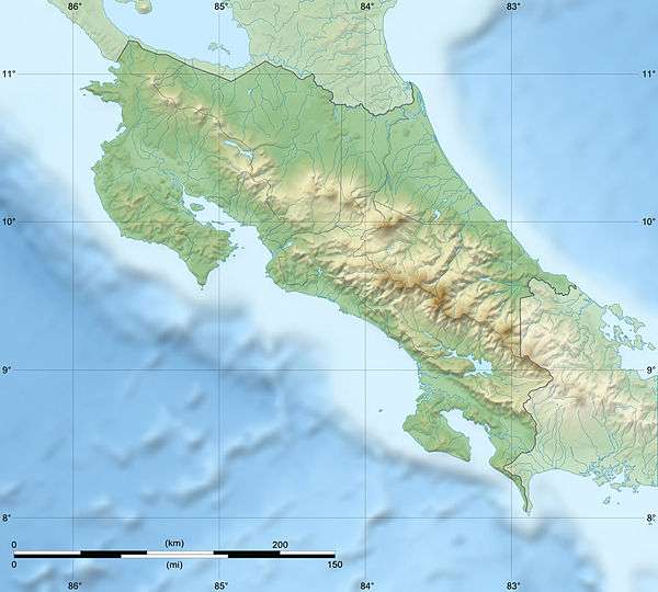
Tortuguero National Park
| Tortuguero National Park | |
|---|---|
|
IUCN category II (national park) | |
|
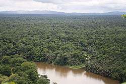
View from Tortuguero Mountain | |
 | |
| Location | Costa Rica |
| Nearest city | Tortuguero |
| Coordinates | 10°32′28″N 83°30′08″W / 10.54111°N 83.50222°WCoordinates: 10°32′28″N 83°30′08″W / 10.54111°N 83.50222°W |
| Area | 312 km2 |
| Established | 1975 |
| Governing body | National System of Conservation Areas (SINAC) |

Tortuguero National Park is a National Park in the Limón Province of Costa Rica. It is situated within the Tortuguero Conservation Area of the northeastern part of the country.[1] Despite its remote location, it is the third-most visited park in Costa Rica, reached only by airplane or boat.[2] The park has a large variety of biological diversity due to the existence within the reserve of eleven different habitats, including rainforest, mangrove forests, swamps, beaches, and lagoons. Located in a tropical climate, it is very humid, and receives up to 250 inches (6,400 mm) of rain a year.[1][2][3]
The park, a protected area within the Humedal Caribe Noreste, was recognized under Ramsar Convention on 3 March 1991 for its rich biological diversity and ecosystems that support threatened flora and fauna species. Set in a natural wetland of the Caribbean coast, it forms a corridor with another protected area, the Indio Maíz Biological Reserve of Nicaragua. It is a key Ramsar Site.[3][4]
Geography


The park is located on the Caribbean coast of Costa Rica, and covers an area of 77,032 acres (31,174 ha). It is bounded with an elevation range of 0–230 metres (0–755 ft), indicative of a sea coastal region to low hilly topography.[4] The Tortuguero National Park has over 20 miles of coastline, which provides sea turtles a protected place to lay their eggs.[5] Tortuguero is bordered on the north by the Barra del Colorado Wildlife Refuge (with habitats and climate similar to Tortuguero), to the south by the mouth of the Parismina River and the Cariari National Wetlands, the town of Tortuguero at the mouth of the Tortuguero River, and the Dr. Archie Carr Wildlife Refuge, which is a biological station to carry out turtle tagging program run by the Caribbean Conservation Corporation (Now known was the Sea Turtle Conservancy).[1][6]
While volcanic activity is reported as formation of a group of small islands, erosion has created the depressions which have a permeable base of "light grey, broken lava rocks, with harder rocks and grey or dark grey lavas overlying". Sandy soils resulting from sedimentation dominates the reserve with formation of parallel bars in the coastal area. The depressions are subject to filling by ephemeral floods; estuary lakes, grass marshes and wooded swamps caused by very heavy rainfall. Small tides of about 40 centimetres (16 in) height have also affected the coastal zone. The small rivers and streams that originate in the hills and flow through the park generally have water 3 metres (9.8 ft) deep. The lakes in the northern part of the reserve are fed by the Colorado River. The very humid tropical forest is influenced by excessive humidity, rapid drainage and thin soils, with over 330 days of cloud cover per year. Moisture-laden winds come from the Caribbean.[4]
The park has worked with the neighboring village of Tortuguero to help its inhabitants understand that preserving their natural resources is the key to encourage eco-tourism.[2] With rich water resources from a precipitation of 250 inches (6,400 mm) per year, the drainage system of the park is fed by many rivers. There are a large number of interlinked canals, water ways and navigable lagoons and lakes that create plains of sediment carried by the river system. The plains are interspersed with rolling hills of forest that were created in ancient days from volcanic cinder cones, of which the Tortuguero Hill and the Lomas de Sierpe of 1,000 feet (300 m) height could be mentioned.[1][2][4] Swaths of the park have been semi-legally clear-cut, which damage also allows access to habitat of the endangered green sea turtle.[7]
Fauna and flora


The national park’s wild life consists of birds, mammals, fungi, ferns, marine life, sea turtles, lakes and rainforest.[8]
Fauna
The coastal zone, which has a long beach extending to nearly 22 miles (35 km), is the nesting ground for turtles popularly known as the "beach-resting turtles (tortugas)". They are found on the beaches, and also many of these species are reported from the canal banks.[3] The main species to lay eggs during the winter months of February to July are: hawksbill, loggerheads, green, and leatherbacks.[2][4] Large parts of the park have been semi-legally clearcut, giving access to the habitat of the endangered green sea turtle.[7] Seven species of Land turtles, the manatee or sea cow, the crocodile, and a variety of crustaceans are found here, as are 30 species of freshwater fish, gar, eel and bull shark.[2]
Tortuguero National Park, acts as an isolated refuge to many of these species which are also found in the La Selva Biological Station and Braulio Carrillo National Park. However, enforcement of protection has remained a challenge.[4] The rivers are home to sensitive populations of manatees, as well as caimans, crocodiles, and tropical gar, which is considered a living fossil. The forests are home to jaguars, three-toed sloths, and three of Costa Rica's four species of monkey: Geoffroy's spider monkey, the mantled howler, and the white-headed capuchin. Basilisk lizards and poisonous frogs also inhabit the area, along with 375 species of birds, including kingfishers, toucans, blue herons, peacocks, and parrots.[2][4] Neotropical migratory birds fly through this park, the noted bird species which is the second largest bird of prey is the crested eagle (Morphnus guianensis).[4]
Species of marine and freshwater fish reported are: The Cichlidae, Characidae, Pimelodidae, Carcharinidae, Centropomidae, and Lutjanidae; minimum of 10 species of freshwater molluscs such as Mytilopsis guianensis.[4]
Reptiles and amphibians reported are: Caiman crocodilus, Chrysemys spp., Rhinoclemmys spp., frogs (Dendrobatidae), and many endemic species of salamanders.[4]
The threatened flora and fauna species in the reserve area are: the American crocodile (Crocodylus acutus), Baird's tapir (Tapirus bairdii), marine turtles such as (Chelonia mydas) and (Dermochelys coriacea), the manatee (Trichechus manatus) (Humedal Caribe Noreste is its feeding and reproduction area) and the only endemic species tropical gar (Atractosteus tropicus) a living fossil brought under protection by Costa Rican legislation. The park is also a migratory stopover for nearly one million birds annually. The park is the breeding ground for subsistence fishing of main fishes along the Caribbean coast of Costa Rica.[4]
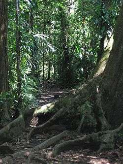
Flora
The national park ecosystem has more than 400 species of trees and about 2,200 species of other plants.[2][4] The wet lowland Atlantic slopes (mostly below 500 metres (1,600 ft)) of northern Costa Rica, particularly along the coast, form into mangrove forests. The forests in this region comprise the Gavilán (Pentaclethra macroloba), Caobilla (Carapa nicaraguensis), the almendro (Dipteryx panamensis) and the monkey pot tree (Lecythis ampla); the last two species (regional endemics of the lowlands found below 250 metres (820 ft)) are stated to be nearly endangered.[9] While 99% of mangrove forests are reported from the Pacific Coast of Costa Rica, only 1% is found in the Caribbean part of the park.[3]
Lakes, marshes and floodplains areas in the park have reported floral varieties such as: Raphia taedigera, trees including Inga spp., Pterocarpus officinalis, Pachira aquatica, Pentaclethra macroloba; large trees with thick and varied undergrowth, several species of small palms; floating aquatic plants in the streams, such as the genera Azolla, Eichhornia, Hydrocotyle and Salvinia (which fully cover the streams during the dry season); other important plant species are, Dipteryx panamensis, Protium spp., Vatairea spp.,Pentaclethra macroloba, Paspalum spp., Luehea seemannii, Manicaria saccifera, Euterpe macrospadix, Brachiaria mutica, Pachira aquatica, Pterocarpus officinalis, and Raphia taedigera.[4]
Uses
Tortuguero National Park is surrounded by private property consisting of large areas under cattle ranching and agricultural farming. The park area itself does not have any permanent human settlement though settlement was reported during the early part of the twentieth century when timber logging, turtle hunting, and collecting and selling skins of large mammals and reptiles were the major activities. The local inhabitants around the park are only permitted to collect forest products to supplement their income and also for domestic use. Fishing and tourism are major activities. Regulated guidance to visitors to access creeks, lakes, nature tails and watching wildlife and also for observing egg-laying by the turtles Chelonia mydas and Dermochelys coriacea. Training workshops as part of environmental education are organized by the park administration (ACTo) on aspects of conservation measures. Even though no research activities are conducted in the park, several institutions are involved in conducting surveys on sea turtles, birds, flora and insects, land tenure and use, and related economic development, there are some guard stations and protection points built within the park.[4]
Regulations for the public use of the Tortuguero National Park provides allowance for public visitation under the specific regulations formulated.[4] The park entrance is accessible from the Cuatro Esquinas center in the village of Tortuguero, in the northern part of the park. A number of trails depart from this point — three aquatic trails and one hiking trail. The hiking trail is called the Gavilan Trail and is 1,920 metres (6,300 ft) long. La Ceiba and La Bomba trails lead up to Tortuguero hill, to a tower which provides a scenic vista of the region. The Sector Jalova Station is further south near Jalova Lagoon and the town of Parismina. Aguas Frias Station is on the western edge close to the town of Cariari.[1] The three water trails are the Harold which is the most popular, Mora, and Chiquero.[1]
Conservation
Illegal clear-cuts within the park has created access for poachers to the once isolated second largest green sea turtle nesting beach in the world.[9] Other threats are due to cutting of Manicaria spp. for use as roofing material, change of river course deforestation, siltation as a result of banana plantations and illegal hunting by outside agencies. The last named threat is most serious and the most affected species are: Agouti paca, Tayassu pecari, Tapirus bairdii, Odocoileus virginianus, Dasypus novemcinctus and marine turtles and their eggs.[3] Some of the developmental activities reported to be directly affecting the park environment are; a hydroelectric project; the new international port of Barra del Parismina; and an interlinking project linking the canals to the Pacific and the Caribbean.[3]
Conservation measures proposed in the core area of the larger Area de Conservación y Desarrollo Sostenible de Llanuras del Tortuguero (ACTo), encompasses the Tortuguero National Park, the Barra del Colorado Wildlife Reserve (40,315 ha) and a border reserve (11,092 ha). The Ministry for the Environment and Energy (MINAE) has the responsibility to manage the project. In 1990-1992, conservation projects were undertaken with the initiative of the Project the Ministry for the Environment and Energy (MINAE) and the European Union (EU), and were implemented by IUCN. The project envisaged "the organisation of land use and agro-forestry, conservation of aquatic resources, strengthening of social structures, facilitating research development, and protecting existing natural and cultural resources."
Gallery
.jpg)


References
- 1 2 3 4 5 6 "Costa Rica National Parks: Tortuguero National Park". Official website of Costa Rica National Parks. Retrieved 23 October 2012.
- 1 2 3 4 5 6 7 8 "Tortuguero National Park". World Headquarters. Costa Rica. Retrieved 23 October 2012.
- 1 2 3 4 5 6 Fodor's Costa Rica. Random House Digital, Inc. 2012. p. 133. ISBN 9780876371657. Retrieved 24 October 2012.
- 1 2 3 4 5 6 7 8 9 10 11 12 13 14 15 "Costa Rica Ramsar Site 811(WI Site 6CR006)". Wetlands International. Retrieved 23 October 2012.
- ↑ Stater, Adam. "Tortuguero National Park".
- ↑ http://www.conserveturtles.org/
- 1 2 World Wildlife Fund; Hogan, C. Michael. Ed. Cutler Cleveland, ed. "Isthmian-Atlantic moist forests". Supported by the Environmental Information Coalition and the National Council for Science and the Environment. Encyclopedia of Earth. Retrieved 23 October 2012.
- ↑ "Costa Rica National Parks". Data and maps adapted from SINAC and MINAE. Official website of Costa Rica National Parks. Retrieved 23 October 2011.
- 1 2 "Isthmian-Atlantic moist forests". Ecoearth organization. Retrieved 23 October 2012.
External links
| Wikimedia Commons has media related to Tortuguero National Park. |
- Tortuguero National Park at Costa Rica National Parks
- History of Tortuguero from Tortuguerovillage.com