Tour de Capu di Muru
| Tour de Capu di Muru | |
|---|---|
 | |
| Coordinates | 41°44′59″N 8°40′35″E / 41.74972°N 8.67639°ECoordinates: 41°44′59″N 8°40′35″E / 41.74972°N 8.67639°E |
| Built | 1600 |
| Designated | 22 April 1994 |
| Reference no. | PA00132603 |
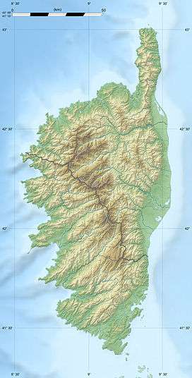 Location of Tour de Capu di Muru in Corsica | |
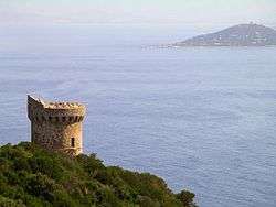
The Tour de Capu di Muru (Corsican: Torra di Capu di Muru) is a Genoese tower located in the commune of Coti-Chiavari (Corse-du-Sud) on the west coast of the French island of Corsica. The tower sits at an elevation of 100 m (330 ft) on the Capu di Muru headland.
The tower was built in around 1600. It was one of a series of coastal defences constructed by the Republic of Genoa between 1530 and 1620 to stem the attacks by Barbary pirates.[1] In 1994 the tower was listed as one of the official historical monuments of France.[2]
The tower is owned and maintained by the Collectivité Territoriale de Corse in an agreement with the French government agency, the Conservatoire du littoral. The agency plans to purchase 215 ha (530 acres) of the headland and as of 2011 had acquired 203 ha (500 acres).[3]
Notes and references
- ↑ Graziani, Antoine-Marie (2000). "Les ouvrages de défense en Corse contre les Turcs (1530-1650)". In Vergé-Franceschi, Michel; Graziani, Antoine-Marie. La guerre de course en Méditerranée (1515-1830) (in French). Paris: Presses de l'Université Paris IV-Sorbonne. pp. 141–142. ISBN 2-84050-167-8.
- ↑ "Monuments historiques: Tour de Capo-di-Muro ou Capu-di-Muru" (in French). Ministère de la culture. Retrieved 4 May 2014..
- ↑ "Tour Genoise de Capu Di Muru". Catalogue monuments historiques (PDF) (Report) (in French). Conservatoire du Littoral, Ministère de l'écologie, du développement durable et de l'énergie, République Française. July 2011. p. 46. Retrieved 27 April 2015.
External links
- "Capo di Muro : Présentation" (in French). I Torregiani. Retrieved 18 May 2014.
- Nivaggioni, Mathieu; Verges, Jean-Marie. "Les Tours Génoises Corses" (in French). Includes information on how to reach 90 towers and many photographs.