Traffic Separation Scheme
≥
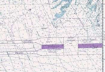
A Traffic Separation Scheme or TSS is a traffic-management route-system ruled by the International Maritime Organization or IMO. The traffic-lanes (or clearways) indicate the general direction of the ships in that zone; ships navigating within a TSS all sail in the same direction or they cross the lane in an angle as close to 90 degrees as possible.
TSSs are used to regulate the traffic at busy, confined waterways or around capes. Within a TSS you normally see at least one traffic-lane in each main-direction, turning-points, deep-water lanes and separation zones between the main traffic lanes. In most TSS schemes you will find Inshore Traffic Zones between the traffic-lanes and the coast. The inshore traffic zone is unregulated and shouldn't be used for ongoing traffic. It is meant for local traffic, fishing and small craft.
A ship navigating in a traffic-lane should sail in the general direction of that lane. The body of water between two opposite lanes is to be avoided by vessels travelling within the TSS as far as possible except in certain circumstances such as emergencies or for fishing activities.
The TSS rules are incorporated in the International Regulations for Preventing Collisions at Sea (Under Part B, Section I, Rule 10- Traffic Separation Schemes)
As said, when sailing within a lane of a TSS that ship has to follow the general direction of the lane. Where needed there are special zones where a lane splits into two channels: one ongoing and the other to the nearby port(s).
Objectives of a TSS
Objectives of IMO Routeing Schemes:
- Help reduce and manage head on situations for the streams of opposing traffic
- Help manage crossing situation arising while entering or coming out of port
- In areas of offshore activities, directives regarding safe distance from the installations
- Providing routes for deep draught vessels
- Avoiding presence of routine traffic from some areas as desired by administration
- Better management of inshore traffic zone, fishing zones and areas dangerous to navigation due to presence of isolated dangers and shoal patches in a high density traffic area.
Crossing a TSS
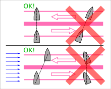
If a ship wants to cross a traffic-lane it should do so at a right angle to avoid endangering ship traffic using the traffic-lanes (although traffic in the lane does not automatically have the right-of-way[1]). To minimize the amount of time a crossing ship spend crossing the traffic-lanes, there should be a right angle between the lane direction and the keel direction - even if currents might shift the actual direction of the ship's movement to some angle other than 90 degrees.
Locations of Traffic Separation Schemes
TSSs are used in locations where there is a lot of traffic (busy shipping areas) where not regulating the traffic would lead to more accidents. In Europe, many TSS areas are found around the Southern part of the North Sea including the English Channel. Other TSS are in place off Land's End and around Ouessant (Ushant).
Well-known TSS locations include: The English Channel, German Bight, Singapore, and Cape Horn. The Dover Strait/Détroit du Pas de Calais was the first International Maritime Organisation (IMO) approved Traffic Separation Scheme in the world in 1967.[2][3]
Other TSS areas can be found in the Mediterranean Sea, western side of the Atlantic Ocean and the Pacific.
See also
References
- ↑ Collision of the Cornelis Vrolijk and the ferry Primrose (Dutch), visited 20 November 2009
- ↑ "The Dover Strait". Dft.gov.uk. Retrieved 2012-10-15.
- ↑ "Fairway" (PDF). Autumn 2011. Retrieved 2012-10-15.
- TSS in the Channel chartlet published by the British Maritime and Coastguard Agency
- IMO, Ships' routeing
- Article 10 of the anti-collision rules of the German Water and Shipping Authority (German)