Transport in Cairo
Transport in Cairo comprises an extensive road network, rail system, subway system and maritime services for the more than 15.2 million inhabitants of the city. Cairo is the hub of almost the entire Egyptian transport network.
Transport today
Road system
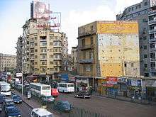
An extensive road network connects Cairo with other Egyptian cities and villages. There is a new ring road that surrounds the outskirts of the city, with exits that reach to almost every Cairo district. There are flyovers, and bridges such as the Sixth of October Bridge, designed to allow fast and efficient means of transport from one side of the city to the other; in practice, however, Cairo traffic is known to be overwhelming and overcrowded, with traffic jams frequently increasing travel time far beyond the theoretical speed.
Bus system
There is a public bus system that offers several lines of service at different prices. There is the standard full-sized bus service run by the Cairo Transport Authority (1 LE) and minibuses run by companies subcontracted by the government (2 LE).[1] Recently most of the CTA buses do not have working air-conditioning.
Other transport services includes the traditional Cairo Taxi and Micro-buses, both are privately run by individuals. The Micro-buses are the cheapest form of transport in Cairo, yet not very reliable. The traditional Cairo Taxi is also run by individuals and usually operate on older models of cars that are being replaced by the effective Cairo Cab for a more modern look in the city.
Egyptians use cabs, cars, and the Nile ferry as methods of transportation.
Air
The largest airport in Egypt, Cairo International Airport, is located near in the Heliopolis district and is accessible by car, taxi and bus. Line 3 of the Cairo Metro, opened in 2012, is being extended to connect the airport to the city; the extension is expected to be complete by 2019.
Cairo International Airport is the busiest airport in Egypt and the primary hub for Star Alliance member EgyptAir. The airport is located to the north-east of the city around 15 km from the business area of the city. The airport is administered by the Egyptian Holding Company for Airports and Air Navigation (EHCAAN), which controls four companies including: Cairo Airport Co., Egyptian Airports Co., National Air Navigation Services and Aviation Information Technology and the Cairo Airport Authority (CAA), which is the regulatory body.
Cairo International is the second busiest airport in Africa after Johannesburg International Airport in South Africa. Cairo Airport handles about 3,400 daily flights, more than 12,100 weekly flights and about 125,000 yearly flights. The airport has three terminals with the third (Terminal 3) opening in April 2009 which houses EgyptAir and its Star Alliance partners. There are also three runways (a fourth runway was opened in early 2009) and a single cargo terminal. Runway 05L/23R is 3,300m long, 05R/23L has a length of 4,000m and 16/34 is 3,180m (all of the runways are 60m wide). The fourth runway, south of the existing airfield is 4,000m by 65m and suitable for the Airbus A380.
With the assimilation of EgyptAir into Star Alliance in July 2008 the airport has the potential to be a major hub with its positioning between Africa, the Middle East and Europe (especially with facilities for the A380).
In 2008, the airport served 14,360,175 passengers (+14.2% vs. 2007) and handled just over 138,000 aircraft movements (+12.4% vs. 2007). According to Airports Council International statistics, of the top 100 airports in the world, CAI reported the highest growth rate of any airport in 2008.
Airport Transfer
Cairo Airport Shuttle Bus cairo airport shuttle bus Shuttle Bus service, it is comfortable, prompt & direct from or to the airport according to your own preference, the latest fleet of vehicles is vast in terms of space & air-conditioned. For groups or single passenger, the Shuttle Bus takes you to any of the following destinations :
Cairo cab
The introduction of a new organized private taxi service was finally realized in March, 2006. The new "yellow" taxis offer a more reliable, luxurious and advanced taxi service in modern air-conditioned cars (Hyundai Elantra, Volkswagen Parati and the Chevrolet Optra) through the help of three privately run companies operating in Cairo, Giza and Qalyubia. There are stops for the cabs and there is a free number to order a cab. The cab drivers speak English for the millions of tourists. An average cab ride is $3 USD, prices may vary on distance.
In subsequent years, an even newer plan for "white" taxis has been implemented and white taxis now vastly outnumber yellow taxis. The Egyptian government has a popular program giving steep discounts on newer more efficient vehicles to taxi owners in exchange for scrapping decades-old Ladas and other black cabs. White cabs all have air conditioning (you might have to ask them to turn it on during summer) and electronic meters with contemporary pricing, allowing tourists and locals to ride without having to bargain for prices. Meters start at 2.5 LE for the first kilometer and add 1.25 LE per kilometer after that, plus 0.25 LE per minute of waiting time, though a 20 km trip to the center could easily become 30 km.
While yellow cabs continue to wait at designated spots, white cabs operate like black cabs, and can be hailed from anywhere in the city. Many white taxis are fueled by compressed natural gas.
The government program is planned to expand to other cities in 2012.
Cairo Metro
The Cairo Metro (Arabic: مترو أنفاق القاهرة Metro Anfāq al-Qāhirah, lit. "Cairo Tunnel Metro" or مترو الأنفاق pronounced [ˈmetɾo lʔænˈfæːʔ]) is the first rapid transit system in Greater Cairo, Egypt and the first of only two full-fledged metro systems in Africa and only four in the Arab world.[8][9] It was opened in 1987 as Line 1 from Helwan to Ramsis square with a length of 29 kilometres (18.0 mi).[10] As of 2014, the Cairo Metro has 61 stations (mostly At-grade), of which 3 are transfer stations, with a total length of 77.9 kilometres (48.4 mi). The system consists of three operational lines numbered from 1 to 3. As of 2013, the metro carried nearly 4 million passengers per day.[2] The Cairo Metro is run by the National Authority for Tunnels. The lines use standard gauge (1,435 mm (4 ft 8
1⁄2 in)).
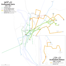
Tram
Constructed near the beginning of the 20th century, until 2014, the Cairo tramway network was still used in modern-day Cairo, especially in modern areas, like Heliopolis, Nasr City. During the 1970s government policies favoured making space for cars, resulting in the removal of over half of the 120 km network. Trams were removed entirely from central Cairo but continued to run in Heliopolis and Helwan.[2] However, in 2015, the tramway rails were removed and the streets and side walks became wider. The reason is that it has been rarely used by anyone during the past decade as it is a slow mean of transportation and it has a limited geographical coverage.
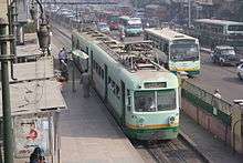
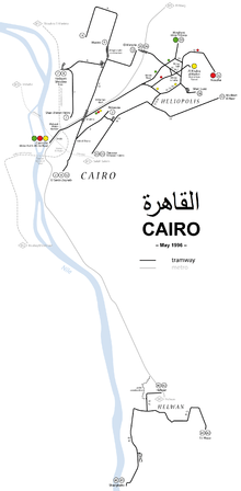
Constructed near the beginning of the 20th century, the Tram system was used in modern-day Cairo, especially in modern areas, like Heliopolis, Nasr City, till 2011-2014. Now it is closed.
Train
Cairo is extensively connected to other Egyptian cities and villages by rail operated by the Egyptian National Railways. Cairo's main railway station - Ramses Station (Mahattat Ramses) is located on Midan Ramses.
Nile ferry
There's a maritime ferry boat system that crosses the Nile River. Here's an article from 2005 about the Nile Bus system. There is also a brief article, published in Al Ahram 2014 about the Nile Bus system.
See also
References
- ↑ "Cairo Bus Types". Cairo Bus Routes. Retrieved 25 April 2015.