Transportation in Indianapolis
Indianapolis is served by many different kinds of transportation.
Airports

Indianapolis International Airport, identified as IND, is the largest airport in Indiana and serves the Indianapolis Metropolitan Area. In addition to a recently completed air traffic control tower, the Indianapolis Airport Authority built a new midfield terminal, two new parking garages and apron improvements. The new terminal was built with the intent of easing passenger access. Constructed between the two existing runways, the new terminal has 40 gates and two concourses. The new Indianapolis International Airport opened for arrivals on November 11, 2008, and departures on the following morning. There are also plans for a third parallel runway south of I-70.
FedEx Express, a cargo airline, operates a national hub out of IND and is the second largest hub operation in the world behind only the Superhub in Memphis. FedEx plans to continue expanding the hub along Interstate 70 or possibly where the old passenger terminal remains. Adding onto the FedEx ramp will allow more wide-body aircraft and more direct flights from IND to FedEx hubs in Europe and Asia.
Cargolux, which flies to Chicago O'Hare, Los Angeles, and Luxembourg, also operates out of IND.
Highways
Interstate Highways
Several interstates serve the Indianapolis area:
 Interstate 65 routes north to the Chicago area and runs south to Louisville.
 Interstate 69 routes north to Fort Wayne, and ends at the I-465 Beltway. Future interstate plans include extending I-69 southwest to Bloomington and Evansville, continuing through Kentucky, Tennessee, Mississippi, Arkansas, Louisiana through Texas to the Mexico border.
 Interstate 70 with transportation to St. Louis and Columbus.
 Interstate 74 to Cincinnati and Danville.
 Interstate 465 serves as a beltway routing around the city and connects to all of the interstate highways.
 Interstate 865 serves as connector to I-65 to I-465, on the northwest side of Indianapolis.
U.S. Highways
State roads
Mass transit

The Indianapolis Public Transportation Corporation, known locally as IndyGo, provides public transportation for the city. IndyGo was established in 1975 after the city of Indianapolis took over privately owned Indianapolis Transit Systems, Inc. Prior to 1997, IndyGo was called Metro. Central Indiana Commuter Services (CICS), funded by IndyGo to reduce pollution, serves Indianapolis and surrounding counties.
Historically, Indianapolis had an extensive network of streetcar routes. In 1953, the last streetcars ran in the city. Trolleybuses made their last run in the city four years later in 1957, leaving the city with an all-bus transit system. The Downtown Indianapolis Streetcar Corp., a not-for-profit organization, is investigating the feasibility of a streetcar line to serve various downtown destinations.[1]
A report prepared by Purdue University indicates that buses running on a fuel containing 10 percent biodiesel are likely to help Indianapolis mass transit reduce pollution without compromising fuel economy. The report also suggests introducing more hybrid diesel-electric buses and a fuel containing 20 percent biodiesel (BD20) would further reduce emissions and petroleum consumption.[2]
IndyGo is in the process of planning for Phase 1 of the Red Line, a new bus rapid transit line running from Broad Ripple Village on the north side to the University of Indianapolis on the south side. This new line will provide more frequent service with fewer stops.
People mover
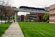
The public-use Indiana University Health People Mover links the Indiana University School of Medicine with the medical centers of University Hospital, Riley Hospital for Children, Methodist Hospital, and related facilities on the campus of Indiana University – Purdue University Indianapolis (IUPUI). The people mover is sometimes inaccurately described as a monorail, but in fact rides on dual concrete beams with the guideway as wide as the vehicle.
Intercity transportation
Amtrak, the national passenger rail system, provides service to Indianapolis at the Indianapolis Union Station. Amtrak provides the tri-weekly service of the Cardinal to Chicago, New York City, and Washington, D.C. and the Hoosier State to Chicago on days the Cardinal does not operate.
Greyhound Lines operates a bus terminal at Union Station downtown. Megabus also runs from downtown Indianapolis, stopping on North Alabama Street adjacent to the Indianapolis City Market.
Transportation issues
Although Indianapolis has managed to sustain a relatively low amount of traffic congestion for a city of its population, this is mostly because the city covers 365 square miles (950 km2),[3] an area much larger than most cities with roughly 840000 people. Indianapolis's low population density might also be the reason the city has yet to further develop its mass transit bus system or a heavy or light rail network. Among urbanized areas with 1,000,000 population or greater in the United States, Indianapolis ranked tenth in freeway lane miles per 1,000 population and eighth in freeway-equivalent miles per 1,000 population.[4]
As the 12th-largest city in the U.S., Indianapolis has repeatedly been ranked below 40th in mass transit availability. However at recent city, county, metropolitan, and statewide meetings, the idea of a heavy rail transportation service has been seriously considered. It would be a four rail system originating at downtown and stretching north, northeast, east, southeast, south, southwest, west, and northwest to the city's suburban areas. The system would be called IndyGo.
Some complaints include:[5]
- the bus-only city mass transit system; the absence of rapid transit and light rail.
- the undue emphasis on automobile travel in city planning; the lack of sidewalks and bike paths.
- excessive automobile usage resulting in environmental degradation (specifically air pollution), as evidenced in the city's often poor air quality
- the lack of cross-town bus routes, forcing bus riders to travel downtown to cross from one side of the city to another, often doubling or tripling what the trip distance would have been with a direct route.
- the "lack of vision" in building a transportation network based entirely on non-renewable resources and old technology
- the paucity of scheduled bus routes, often forcing riders to choose between arriving at a destination extremely early, or late.
- the lack of night bus services, which forces those who work late shifts to find other ways to get around. These can be much more expensive.
- the fiscal costs of building (for instance liens), repairing, and replacing roads
There are other concerns over a lack of safe walking paths in many areas of the city. Many suburbs which were incorporated in the 1960s and 1970s are now relatively near the center of the city, and don’t have sidewalks. This often forces pedestrians to navigate a narrow road shoulder near high-speed automobile traffic.
See also
References
- ↑ "IBJ.com Story Detail". Ibj.com. Retrieved 2008-11-06.
- ↑ "Emerging Energy News: Purdue: Biodiesel cuts carbon emission from buses". Energycurrent.com. Retrieved 2008-11-06.
- ↑ The 2005 Urban Mobility Report
- ↑ The Public Purpose Highway & Motorway Fact Book - Lane Miles per Capita 1999:US Urbanized Areas over 1,000,000
- ↑ Indianapolis Transportation Woes