Trassenheide
| Trassenheide | ||
|---|---|---|
 | ||
| ||
 Trassenheide | ||
Location of Trassenheide within Vorpommern-Greifswald district 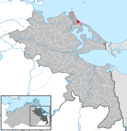 | ||
| Coordinates: 54°06′N 13°52′E / 54.100°N 13.867°ECoordinates: 54°06′N 13°52′E / 54.100°N 13.867°E | ||
| Country | Germany | |
| State | Mecklenburg-Vorpommern | |
| District | Vorpommern-Greifswald | |
| Municipal assoc. | Usedom-Nord | |
| Government | ||
| • Mayor | Dirk Schwarze | |
| Area | ||
| • Total | 6.50 km2 (2.51 sq mi) | |
| Population (2015-12-31)[1] | ||
| • Total | 904 | |
| • Density | 140/km2 (360/sq mi) | |
| Time zone | CET/CEST (UTC+1/+2) | |
| Postal codes | 17449 | |
| Dialling codes | 038371 | |
| Vehicle registration | VG | |
| Website | www.seebad-trassenheide.de | |

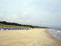
Trassenheide is a seaside resort on the island of Usedom in the state of Mecklenburg-Vorpommern, in Germany. Trassenheide has approximately 1,000 inhabitants and the main source of income is tourism.
History
The first documented mention of Trassenheide was in 1786, first under the designation "mutton stable"; a large sheep stable had been established to protect herds of sheep against sudden flooding by the Baltic Sea. By 1840 there were 138 inhabitants. In 1908 the colony was named "Trassenheide". At this time tourism began. In 1928 Trassenheide was made an independent municipality. In August 1943 it was heavily damaged by a bomb attack aimed at the neighbouring Luftwaffe rocket research station in Peenemünde.
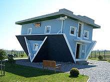
Upside-Down House
On September 4, 2008 an upside-down house was built as a source of tourism. The architects, Polish partners Klaudiusz Golos and Sebastian Mikiciuk designed the house as part of the project 'The World Upside Down' that should allow visitors a different view of every day items. Since the whole interior is upside-down and can disorient some, the house will be used purely as an exhibit.[2]
The project was completed in August 2008.
References
- ↑ "Bevölkerungsstand der Kreise, Ämter und Gemeinden in Mecklenburg-Vorpommern 31.12.2015". Statistisches Amt Mecklenburg-Vorpommern (in German). July 2016.
- ↑ "Upside-down house opens doors in Germany". yahoo.com. Archived from the original on September 17, 2008. Retrieved September 4, 2008.
External links
![]() Media related to Trassenheide at Wikimedia Commons
Media related to Trassenheide at Wikimedia Commons