Trempealeau County, Wisconsin
| Trempealeau County, Wisconsin | |
|---|---|
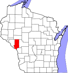 Location in the U.S. state of Wisconsin | |
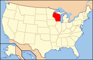 Wisconsin's location in the U.S. | |
| Founded | 1855 |
| Seat | Whitehall |
| Largest city | Arcadia |
| Area | |
| • Total | 742 sq mi (1,922 km2) |
| • Land | 733 sq mi (1,898 km2) |
| • Water | 9.0 sq mi (23 km2), 1.2% |
| Population | |
| • (2010) | 28,816 |
| • Density | 39/sq mi (15/km²) |
| Congressional district | 3rd |
| Time zone | Central: UTC-6/-5 |
| Website |
www |
Trempealeau County is a county located in the U.S. state of Wisconsin. As of the 2010 census, the population was 28,816.[1] Its county seat is Whitehall.[2]
History
Patches of woodland are all that remain of the brush and light forest that once covered the county. In ancient times, the woodlands contained a great deal of timber, but Native Americans burned them periodically to encourage the growth of berries. They did little cultivation and had been almost completely removed from the area by 1837.[3]
French fur traders were the first Europeans to enter this land, traveling by river across the county. At the mouth of the Trempealeau River at its confluence with the Mississippi River, they found a bluff surrounded by water and called it La Montagne qui trempe à l’eau, which means 'mountain steeped in water' (now known as Trempealeau Mountain.[4][5] The name was later shortened to Trempealeau.[6] Created in 1854 and organized in 1855,[7] the county is named after the river.[8]
Geography
According to the U.S. Census Bureau, the county has a total area of 742 square miles (1,920 km2), of which 733 square miles (1,900 km2) is land and 9.0 square miles (23 km2) (1.2%) is water.[9] It is part of the Driftless Zone.
Adjacent counties
- Buffalo County - west
- Eau Claire County - north
- Jackson County - east
- La Crosse County - southeast
- Winona County, Minnesota - southwest
Major highways
National protected areas
- Trempealeau National Wildlife Refuge (part)
- Upper Mississippi River National Wildlife and Fish Refuge (part)
Demographics
| Historical population | |||
|---|---|---|---|
| Census | Pop. | %± | |
| 1860 | 2,560 | — | |
| 1870 | 10,732 | 319.2% | |
| 1880 | 17,189 | 60.2% | |
| 1890 | 18,920 | 10.1% | |
| 1900 | 23,114 | 22.2% | |
| 1910 | 22,928 | −0.8% | |
| 1920 | 24,506 | 6.9% | |
| 1930 | 23,910 | −2.4% | |
| 1940 | 24,381 | 2.0% | |
| 1950 | 23,730 | −2.7% | |
| 1960 | 23,377 | −1.5% | |
| 1970 | 23,344 | −0.1% | |
| 1980 | 26,158 | 12.1% | |
| 1990 | 25,263 | −3.4% | |
| 2000 | 27,010 | 6.9% | |
| 2010 | 28,816 | 6.7% | |
| Est. 2015 | 29,550 | [10] | 2.5% |
| U.S. Decennial Census[11] 1790–1960[12] 1900–1990[13] 1990–2000[14] 2010–2014[1] | |||

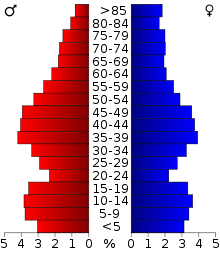
As of the census[15] of 2000, there were 27,010 people, 10,747 households, and 7,243 families residing in the county. The population density was 37 inhabitants per square mile (14/km2). There were 11,482 housing units at an average density of 16 per square mile (6/km²). The racial makeup of the county was 98.81% White, 0.13% Black or African American, 0.17% Native American, 0.13% Asian, 0.01% Pacific Islander, 0.29% from other races, and 0.47% from two or more races. 0.89% of the population were Hispanic or Latino of any race. 39.0% were of Norwegian, 24.6% German and 17.0% Polish ancestry according to Census 2000. 94.9% spoke English, 1.6% Norwegian and 1.6% Spanish as their first language.
There were 10,747 households out of which 31.80% had children under the age of 18 living with them, 55.20% were married couples living together, 7.40% had a female householder with no husband present, and 32.60% were non-families. 27.60% of all households were made up of individuals and 13.50% had someone living alone who was 65 years of age or older. The average household size was 2.45 and the average family size was 3.00.
In the county, the population was spread out with 25.30% under the age of 18, 6.90% from 18 to 24, 28.20% from 25 to 44, 23.10% from 45 to 64, and 16.40% who were 65 years of age or older. The median age was 38 years. For every 100 females there were 100.30 males. For every 100 females age 18 and over, there were 98.80 males.
Communities
Cities
- Arcadia
- Blair
- Galesville
- Independence
- Osseo
- Whitehall (county seat)
Villages
Towns
Census-designated place
Unincorporated communities
Ghost towns
See also
References
- 1 2 "State & County QuickFacts". United States Census Bureau. Retrieved January 24, 2014.
- ↑ "Find a County". National Association of Counties. Retrieved 2011-06-07.
- ↑ Gamroth, 1976, p. 5, 87
- ↑ "Trempealeau County Marking 100th Anniversary on Sunday". The Winona Republican-Herald. January 23, 1954. p. 5. Retrieved October 14, 2014 – via Newspapers.com.

- ↑ "Judge Gale Led Legislative Drive to Recognize Area". The Winona Republican-Herald. January 23, 1954. p. 5. Retrieved October 14, 2014 – via Newspapers.com.
- ↑ Elkins, 1985, p.1
- ↑ "Wisconsin: Individual County Chronologies". Wisconsin Atlas of Historical County Boundaries. The Newberry Library. 2007. Retrieved August 15, 2015.
- ↑ "Winnebago Took Its Name from an Indian Tribe". The Post-Crescent. December 28, 1963. p. 14. Retrieved August 25, 2014 – via Newspapers.com.
- ↑ "2010 Census Gazetteer Files". United States Census Bureau. August 22, 2012. Retrieved August 9, 2015.
- ↑ "County Totals Dataset: Population, Population Change and Estimated Components of Population Change: April 1, 2010 to July 1, 2015". Retrieved July 2, 2016.
- ↑ "U.S. Decennial Census". United States Census Bureau. Retrieved August 9, 2015.
- ↑ "Historical Census Browser". University of Virginia Library. Retrieved August 9, 2015.
- ↑ Forstall, Richard L., ed. (March 27, 1995). "Population of Counties by Decennial Census: 1900 to 1990". United States Census Bureau. Retrieved August 9, 2015.
- ↑ "Census 2000 PHC-T-4. Ranking Tables for Counties: 1990 and 2000" (PDF). United States Census Bureau. April 2, 2001. Retrieved August 9, 2015.
- ↑ "American FactFinder". United States Census Bureau. Retrieved 2011-05-14.
Further reading
- Biographical History of La Crosse, Trempealeau and Buffalo Counties, Wisconsin.. Chicago: Lewis Publishing, 1892.
- Curtiss-Wedge, Franklyn (comp.). History of Trempealeau County, Wisconsin. Chicago: H. C. Cooper, Jr. 1917.
- Elkins, Winston (1985). Trempealeau and the Mississippi River Dam. Trempealeau County, Wis.: Trempealeau County Historical Society.
- Gamroth, Clarence J. (Ed.) (1976). Historical Album, 100 Years, Independence, Wisc. Independence, Wis.: City of Independence.
External links
- Trempealeau County
- Trempealeau County map from the Wisconsin Department of Transportation
- Trempealeau County Health and Demographic Data
 |
Eau Claire County | | ||
| Buffalo County | |
Jackson County | ||
| ||||
| | ||||
| Winona County, Minnesota | La Crosse County |
Municipalities and communities of Trempealeau County, Wisconsin, United States | ||
|---|---|---|
| Cities | | |
| Villages | ||
| Towns | ||
| CDP | ||
| Unincorporated communities | ||
| Ghost towns | ||
Coordinates: 44°18′N 91°21′W / 44.30°N 91.35°W