Tulul adh-Dhahab
The Tulul adh-Dhahab (also: Tall / Telul edh Dhehab, Arabic: تلول الذهب), Jordan, are two adjacent tells in the Zarqa River valley, a sidevalley of the Jordan Valley about an hour's drive northwest of Amman in Jordan. The western of the twin hills was populated at least from Bronze Age to Late Antiquity, a beginning of settlement in the Neolithic period is also possible. After the collapse of the ancient buildings probably by an earthquake in Late Antiquity there was no subsequent settlement on the site. Because of the unfortunate name ("hill of gold") there have been extensive recent disruptions.[1]
Location
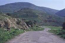
The double hills (hence the plural 'Tulūl', proper: dual 'Tellan' rather than the singular' Tell 'and' Tall ') are situated - about only 35 km northwest of the Jordanian capital, Amman - in the Zarqa River valley, the biblical Jabbok, at the opening of the southern Wadi Hajjaj. The two twin-like natural hills, both of them bearing ruins, are both app. 120 m above the riverbed and forcing the Zarqa River on a winding course around them. Until the 20th century the twin hills obstructed the way to the Zarqa valley heading east. Ancient hikers had to dodge the way into to the Zarqa valley and head to the Wadi Hajjaj, the shortest way to settlement area of the Ammonites. That is the reason why the Tulul adh-Dhahab had, until the construction of the Roman road at the exit of Wadi az-Zarqa in Jordan Valley near the present village of Abu Zighan, a high strategic importance.[2] Only about 6.5 kilometers west of the Tulul adh-Dhahab there is the large Tell of Dayr 'Alla (also written as Deir Alla), dating to the Bronze and Iron Age.
Discovery
The research of the late 19th and 20th century was confirmed by the descriptions of the Tulul adh-Dhahab by S. Merrill (1878, 1881), G. Gustav Dalman, C. Steuernagel and others. M. North conducted a topographic surveys by 1955. But it were the American archaeologists Robert L. Gordon and Linda E. Villiers who carried out a major survey in the years of 1980 and 1982. They published the first map of the ruins that were still visible at this time.
The excavations since 2005

A team from the University of Dortmund, under the direction of Prof. Dr. Thomas Pola, investigated in cooperation with the Jordanian Department of Antiquities (DoA) the western of the two hills more closely since 2005.[3][4] Since 2006 a team of the University of Basle is involved in the excavations. They are engaged in the geomagnetic prospection, the tachymetrical 3D surveying and the production of close-range aerial photographs for photogrammetric purposes[5] of the site. In addition to the work of R. L. Gordon in 1980/82, there is now for the first time a detailed map of the entire excavation site available in which all the visible surface artifacts are measured.
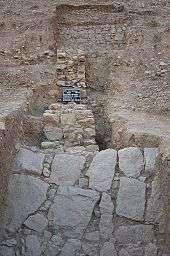
On the two highest terraces of the hill so far three settlement phases were detected archaeologically. (I) The earliest settlement dates from the period 1300 - 970 BC (14C data); previously no associated architectural remains were found, but layers and a wide variety of finds. At least one predecessor of the fortified wall that surrounds Terrace I and II is contemporary to this earliest phase. The carved lime rock ashlars that were embedded in the later architecture (II-III) as building material could originate from a cult or representative building of this earliest phase or a little later from the period 900-700 BC. The three largest and most interpretable fragments that were found so far show (a) the head of a decorated lion, (b) a woman or child with a goat, and (c) a with (a-b) stylistically similar illustration of two (seated?) beardless persons, each are holding an instrument in front of them that surmount their heads considerably, maybe a harp. - (II) So far only few sections on the top terrace showed foundations of buildings built in the period 375 - 175 BC. Most of these features were destroyed during the construction of the youngest phase. - (III) On the highest plateau a palatial building of approximately 30 x 30 meters was built with two adjacent peristyle courts, each about 15 x 15 meters in size and angled eastwards. The fragments of architecture of this palace are stylistically placed in the late Hellenistic period or the early years of Herod I. (73 - 4 BC), coins and 14C data corroborate this time approach. Detailed findings suggest that some of this architecture were two-story buildings. Besides lime stone also mud bricks were used as building material. This palace ended with a fire event probably after about 50-25 BC, then the facility was vacated and not used again. Later most of the still standing architecture collapsed in an earthquake. - The top two terraces on the steep eastern and south slope were surrounded by a today about 0.5 - 1.5m high preserved wall, its original height is not known. At its inner line room like foundations are set. The layer and period relationship of these walls with the two successive palaces (II and III) could not be clarified yet.
Only slightly above the Jabbok river (Nahr az-Zarqa), but safely above the flood line, at the southern foot of the West Tulul adh Dhahab lies a Bronze Age settlement. The previously oldest charcoal from the upper terraces, which has been dated to 1960 -1750 BC (14C date) probably belongs to this settlement and was associated with building materials that were transported to the top of the hill.
Identification
The discussion about the question with what ancient place Tulul adh-Dhahab could be identified is controversial. Sites mentioned in the Old Testament (Pnuël / Penuel, Mahanaim) or mentioned by the ancient historian Flavius Josephus (Amathous, Essa) are discussed.
References
- ↑ http://ochesnut.wordpress.com/tag/tulul-adh-dhahab/
- ↑ Siegfried Mittmann: Die römische Straße in der nordwestlichen Belka. In: Zeitschrift des Deutschen Palästina-Vereins. Bd. 79, 1963, ISSN 0012-1169, S. 152–163.
- ↑ Thomas Pola, Hannelore Kröger, Bernd Rasink, Jochen Reinhard, Mohammad al-Balawnah, Mohammad Abu Abila: A preliminary report of the Tulul adh-Dhahab (Wadi az-Zarqa) survey and excavation seasons 2005 - 2011. In: Annual of the Department of Antiquities of Jordan 57, 2013 (2016), ISSN 0449-1564, S. 81–96 (Link).
- ↑ Boris Dreyer: Tulul adh-Dhahab (Wadi az-Zarqa) lead sling bullets from Terrace I. In: Annual of the Department of Antiquities of Jordan 57, 2013 (2016), ISSN 0449-1564, S. 97–104.
- ↑ Jochen Reinhard: Things on strings and complex computer algorithms. Kite Aerial Photography and Structure from Motion Photogrammetry at the Tulul adh-Dhahab, Jordan. In: AARGnews 45, 2012, ISSN 1756-753X, S. 37–41 (Link).
Bibliography
- Boris Dreyer: Tulul adh-Dhahab (Wadi az-Zarqa) lead sling bullets from Terrace I. In: Annual of the Department of Antiquities of Jordan 57, 2013 (2016), ISSN 0449-1564, S. 97–104.
- Martin Noth: The German Protestant Institute of Science Antiquity of the Holy Land. Lehrkursus the 1955th. In: Journal of the German Palestine Society. Vol. 72, 1956, ISSN 0012-1169, p. 31-82, here: 52-58.
- Robert L. Gordon, Linda E. Villiers: Telul edh Dhahab and its environs surveys of 1980 and 1982: a preliminary report. In: Annual of the Department of Antiquities of Jordan. Vol. 27, 1983, p. 275-289.
- Robert L. Gordon: Telul edh Dhahab Survey (Jordan) 1980 and 1982. In: Mitteilungen der Deutschen Orient-Gesellschaft zu Berlin. Vol. 116, 1984, p. 131-137.
- Thomas Pola, Mohammad al-Balawnah, Wolfgang Thiel, Emmanuel Rehfeld, Tobias Krause: Fragments of Carved Stones from Tulul adh-Dhahab in the Lower Wadi az-Zarqā. In: Journal of Epigraphy & Rock Drawings. Bd. 3, 2009, S. 17–24.
- Thomas Pola, Ritzzeichnungen. Werfen archäologische Funde aus dem Ostjordanland Licht auf Ez 8,10 und 1Kön 6,29-36? In: Theologische Beiträge. Vol. 41, 2010, p. 97-113.
- Thomas Pola, Hannelore Kröger, Bernd Rasink, Jochen Reinhard, Mohammad al-Balawnah, Mohammad Abu Abila: A preliminary report of the Tulul adh-Dhahab (Wadi az-Zarqa) survey and excavation seasons 2005 - 2011. In: Annual of the Department of Antiquities of Jordan 57, 2013 (2016), ISSN 0449-1564, S. 81–96 (Link).
- Jochen Reinhard: Things on strings and complex computer algorithms. Kite Aerial Photography and Structure from Motion Photogrammetry at the Tulul adh-Dhahab, Jordan. In: AARGnews 45, 2012, ISSN 1756-753X, S. 37–41 (Link or Link).
External links
-

Wikimedia Commons has media related to Tulul adh-Dhahab. - Album with pictures, videos and audio files
- Former official project homepage at the website of the TU Dortmund
- Report on the Excavation TU Dortmund 2006
- Jordan Times article of the 2008 campaign
- Rule of the german newspaper WAZ in the excavation project
- Photo of a head made of ceramics
Coordinates: 32°11′08″N 35°41′12″E / 32.185650°N 35.686611°E