Tumalo Creek
| Tumalo Creek | |
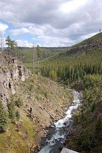 Below Tumalo Falls | |
| Name origin: Perhaps from the Klamath word for wild plum [1] | |
| Country | United States |
|---|---|
| State | Oregon |
| County | Deschutes |
| Source | confluence of Middle and North forks of Tumalo Creek |
| - location | Deschutes National Forest near Mount Bachelor, Cascade Range |
| - elevation | 5,597 ft (1,706 m) [2] |
| - coordinates | 44°02′49″N 121°35′55″W / 44.04694°N 121.59861°W [3] |
| Mouth | Deschutes River |
| - location | north of Bend, upstream of Tumalo State Park |
| - elevation | 3,245 ft (989 m) [3] |
| - coordinates | 44°06′57″N 121°20′22″W / 44.11583°N 121.33944°WCoordinates: 44°06′57″N 121°20′22″W / 44.11583°N 121.33944°W [3] |
| Length | 20 mi (32.2 km) [4] |
| Basin | 59 sq mi (153 km2) [5] |
| Discharge | |
| - average | 75 cu ft/s (2 m3/s) [6] |
| - max | 250 cu ft/s (7 m3/s) |
 Location of the mouth of Tumalo Creek in Oregon | |
Tumalo Creek is a tributary, about 20 miles (32 km) long,[4] of the Deschutes River, located in Deschutes County in Central Oregon, United States. It rises in the Cascade Range at 44°02′49″N 121°35′55″W / 44.04706°N 121.598647°W, where Middle Fork Tumalo Creek and North Fork Tumalo Creek meet, and forms several waterfalls, including the 97-foot (30 m) Tumalo Falls. Its mouth is on the Deschutes at 44°06′57″N 121°20′22″W / 44.1159506°N 121.3394783°W.[7]
It is home to several species of trout, including the Columbia River redband trout. It is the primary drinking water source for the city of Bend.[8] The lower reaches of the creek are often emptied for irrigation, drained by a tunnel flume at 44°05′45″N 121°21′35″W / 44.09589°N 121.35966°W and Tumalo Canal at 44°05′45″N 121°21′35″W / 44.09591°N 121.35970°W.
The 1979 Bridge Creek Fire and related salvage logging increased erosion and damaged habitats in and near Tumalo Creek. Since 2003, a network of government agencies and volunteer groups have been working to restore fish and wildlife habitat along a 3-mile (5 km) stretch of the stream.[9]
See also
References
- ↑ McArthur, Lewis A.; Lewis L. McArthur (2003) [1928]. Oregon Geographic Names (7th ed.). Portland, Oregon: Oregon Historical Society Press. p. 973. ISBN 0-87595-277-1.
- ↑ Source elevation derived from Google Earth search using GNIS source coordinates.
- 1 2 3 "Tumalo Creek". Geographic Names Information System (GNIS). United States Geological Survey. November 28, 1980. Retrieved April 30, 2012.
- 1 2 Sheehan, Madelynne Diness (2005). Fishing in Oregon (10th ed.). Scappoose, Oregon: Flying Pencil Publications. p. 249. ISBN 0-916473-15-5.
- ↑ United States Forest Service. "Tumalo Creek Bridge to Bridge Restoration Environmental Assessment" (PDF). University of Oregon. p. 4. Retrieved April 30, 2012.
- ↑ "Tumalo Creek". Deschutes River Conservancy. Retrieved April 30, 2012.
- ↑ "Tumalo Creek". Geographic Names Information System. United States Geological Survey. 28 November 1980. Retrieved August 28, 2011.
- ↑ Lindsey, Ethan (June 10, 2009). "Bend considers building a hydroelectric project on Tumalo Creek". OPB News. Portland, Oregon. Retrieved August 28, 2011.
- ↑ "Tumalo Creek Restoration Project". Upper Deschutes Watershed Council. Retrieved April 30, 2012.
External links
| Wikimedia Commons has media related to Tumalo Creek. |