U.S. Route 10 in Michigan
| ||||
|---|---|---|---|---|
|
US 10 highlighted in red | ||||
| Route information | ||||
| Maintained by MDOT | ||||
| Length: | 139.656 mi[1] (224.755 km) | |||
| Existed: | November 11, 1926[2] – present | |||
| Tourist routes: | ||||
| Major junctions | ||||
| West end: |
| |||
| East end: |
| |||
| Location | ||||
| Counties: | Mason, Lake, Osceola, Clare, Isabella, Midland, Bay | |||
| Highway system | ||||
| ||||

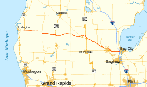
US Highway 10 (US 10) is a part of the United States Numbered Highway System that runs from West Fargo, North Dakota, to the Lower Peninsula of the US state of Michigan. The highway enters Michigan on the SS Badger, which crosses Lake Michigan between Manitowoc, Wisconsin, and Ludington. As the highway crosses the state, it is a two-lane undivided highway between Ludington and Farwell and a freeway from Farwell east to the highway's terminus in Bay City. US 10 runs concurrently with US 127 in the Clare area along a section of freeway that includes a welcome center in the median. Outside of the Clare and Midland areas, US 10 runs through rural areas of Western and Central Michigan in a section of the Manistee National Forest as well as farm fields.
As part of the original US Highway System, US 10 was first designated in Michigan in 1926. It replaced three state trunkline highways of the day: M-20, M-24 and M-10, running between Ludington on Lake Michigan and downtown Detroit. It also ran concurrently with US 23 between Saginaw and Flint. The highway has been realigned several times during the construction of Interstate 75 in southeast Michigan, even being temporarily designated "TO I-75" to connect segments of the I-75 freeway. The US 10 freeway between Clare and Midland was opened in the early 1960s. The Michigan Department of Transportation (MDOT) truncated the highway to Bay City in 1986, removing it from I-75 and the Lodge Freeway.
Route description
Through the Lower Peninsula, US 10 is both an undivided highway and a freeway maintained by MDOT. The entire 140-mile (230 km) length has been listed on the National Highway System,[3] a network of roads important to the country's economy, defense, and mobility.[4] US 10 is also one of only two highways in the state that utilizes a car ferry, the other being M-134 in the Upper Peninsula.[5]
Undivided highway
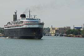
US 10 enters the state after it crosses Lake Michigan from Manitowoc, Wisconsin, to Ludington. Traffic is carried across the lake during the summer months on the SS Badger, a privately owned carferry.[6] Heading eastward from the ferry, the highway runs along Pere Marquette Lake and then northward through a light industrial area along James Street in Ludington. At the intersection with Ludington Avenue in the downtown business area, the trunkline turns to the east. US 10 runs through commercial and residential areas on its course out of town. Near the Mason County Airport, the highway intersects the northern end of Business US 31 (Bus. US 31, Pere Marquette Highway). About a mile and a half (2.4 km) east of that intersection, US 10 meets the interchange that marks the northern end of the US 31 freeway in the state. From here to Scottville, the two highways run concurrently together through a mix of rural fields and forests. On the west side of town, US 31 turns northward along the Scottville Bypass, and US 10 continues through the middle of town on State Street. The road heads eastward roughly parallel to the Pere Marquette River.[5][7] Near Custer, US 10 crosses into the Manistee National Forest.[8]
The trunkline continues eastward through the forest passing north of the community of Walhalla. At Branch, it crosses out of Mason County and enters Lake County, jogging to the southeast through town. South of Long Lake, the roadway returns to a due easterly course. North of Baldwin, US 10 turns southerly and merges with M-37. The two highways run together for about three miles (4.8 km) into town on Pine Street before separating. US 10 follows Washington Street easterly and exits town. The roadway passes near several small lakes near Idlewild and turns southeasterly into Chase.[5][7] The highway exits the Manistee National Forest,[8] and runs through farm fields as it continues across the county line into Osceola County.[5][7]
Northwest of Reed City, US 10 meets the US 131 freeway before curving around the north side of town. The highway passes to the south of Nartron Field near the intersection with Bus. US 10. The highway crosses the White Pine Trail State Park, a rail trail that runs north through the area. US 10 continues east around the north side of town and runs parallel to the Pere Marquette State Trail, an east–west rail trail that follows the Ludington Division of the Pere Marquette Railway. The highway intersects the business loop on the east side of town and exits Reed City. US 10 continues east and northeasterly though rural fields in Osceola County. The highway passes to the north of Evart Municipal Airport and enters the city of Evart. It runs along 7th Street through downtown before and crossing the Muskegon River and exiting the city. The trunkline runs parallel to the rail trail through rural country side to north of the small community of Sears before turning to the southeast. US 10 passes between Big Mud, Big Cranberry and Mystic Lakes as it crosses into Clare County. The highway continues to the east, and near Farwell, it transitions to a full freeway. [5][7]
Freeway routing
Immediately after the traffic lanes spread apart to form the separate carriageways of the freeway, US 10 has an interchange with M-115. This interchange, like most of them along the US 10 freeway has no exit number although the freeway contains mileposts based on the mileage from Ludington. There is another interchange near Lake Thirteen for Old State Avenue that provides access to Farwell. About five miles (8.0 km) east of here, US 10 meets US 127 north of Clare. These two freeways merge and run south toward Clare, using the mileposting and exit numbering of US 127 along the concurrency. Near a curve to the southeast, there is an MDOT Welcome Center located in the median between the two halves of the freeway. Past this facility is an interchange that connects to Bus. US 127/Bus. US 10 which provides access to downtown Clare. The freeway turns to the south between Lake Shamrock and the Clare Municipal Airport. US 10 separates from US 127 at a partial interchange south of the airport using a left exit southbound to continue on eastbound US 10. The connections for westbound US 10 to southbound US 127 or northbound US 127 to eastbound US 10 are made using the business routes through downtown.[5][7]
The interchange that marks the southern end of the US 127/US 10 concurrency is also the place where US 10 crosses into the northeastern corner of Isabella County. About three miles (4.8 km) east of there, US 10 has its partial interchange with the eastern end of the Clare business loop. The freeway continues southeasterly now parallel to the Pere Marquette Rail-Trail, another former rail line of the Pere Marquette Railway. US 10 bypasses the community of Loomis to the north before crossing into Midland County near Coleman. The landscape through this area is dominated by farms. US 10 bypasses North Bradley connecting with an interchange that marks the southern terminus of M-18. Further along, the freeway crosses the southern end of Sanford Lake on a set of bridges; on the eastern shore there is an interchange with M-30 (Meridian Road) that connects to Sanford.[5][7]
After crossing the lake, the freeway runs southeasterly roughly parallel to the Tittabawassee River for about three miles (4.8 km) until the interchange with Stark Road. US 10 turns to run due east between Airport Road to the north and Wackerly Street to the south. The freeway passes the Jack Barstow Municipal Airport as it enters Midland. At the interchange with Eastman Avenue, the city's business loop departs to connect to downtown, and the freeway passes near the Midland Mall and the Midland County Fairgrounds. Two miles (3.2 km) further east, US 10 turns to the southeast, bordered by residential subdivisions of the city of Midland to its south and vacant fields to its north. There is a partial interchange that straddles the Midland–Bay county line that provides access to the eastern end of Bus. US 10/M-20, which is also a freeway on this side of town. Traffic exiting the business loop freeway is forced onto US 10 eastbound, and only westbound US 10 traffic and enter the westbound direction of Bus. US 10/M-20; the other connections are possible by using the adjoining Bay City Road interchange on US 10 and the Waldo Avenue interchange on the business loop.[5][7]
Past the Bay City Road interchange, US 10 continues due east through Bay County. It intersects the northern end of the M-47 freeway. Further east, there are a pair of interchanges for Auburn as the freeway runs through a landscape that is a mix of suburban residential subdivisions and farm fields. The freeway is paralleled to the south by segments of Fisher Road in spots; about a half mile (0.8 km) north is Midland Road. There is one last interchange for Mackinaw Road along the freeway before US 10 ends at the cloverleaf interchange with I-75/US 23 on the west side of Bay City. This junction is both the eastern terminus of US 10 both in the state of Michigan and nationally.[5][7]
History


The first state trunkline highways designated along the original path of US 10 were M-20, M-24 and M-10 as far back as 1919.[9] When the US Highway System was announced on November 11, 1926,[2] US 10 replaced these designations. The highway started in Ludington and ran east replacing M-20 to Midland, M-24 to Saginaw and M-10 to Detroit. Between Saginaw and Flint, US 10 and US 23 were routed concurrently.[10]
Two changes were made in the routing of US 10 by 1929. As shown on the maps of the time, US 10 was rerouted to bypass Flint. The former routing through the city was redesigned M-10. A second change moved the highway to its present routing west of Baldwin to the Lake–Mason county line.[11][12] A bypass of downtown Midland was opened in 1934. The previous routing through town was initially renumbered US 10A.[13] A rerouting project in Osceola County started in 1936. By the end of the year, a new roadway was opened between Sears and M-66.[14] Until the second segment of the project was completed two years later, US 10 was routed concurrently with M-66. When the new routing between M-66 and Lake in Clare County was opened, that concurrency was eliminated and all the previous routings were transferred to local control.[15]
By 1942, the M-10 designation in Flint was renumbered Bus. US 10, eliminating the second M-10 designation from the maps.[16] The last segments of US 10 that were gravel-surfaced were paved by 1948. The last section paved was between Chase and Reed City.[17]
A bypass of Saginaw was completed by 1953. This new roadway was designated as US 23 alone. The highway through downtown Saginaw was numbered US 10/Bus. US 23.[18] The Fenton–Clio Expressway was completed in 1957 from Birch Run past Flint. The new expressway was numbered US 23, leaving the former highway through Flint as just US 10.[19][20] A bypass of Reed City opened by 1960; the former routing was renumbered Bus. US 10.[21][22]
Many changes were made in 1960 to the routing of US 10. A new freeway opened for I-75/US 10/US 23 between M-13 northeast of Saginaw and the M-20 freeway in Bay City. US 10 replaced the M-20 designation on the freeway between Midland and Bay City. M-47 replaced US 10 between Midland and Saginaw, and M-81 replaced US 10 in the city of Saginaw. An addition segment of US 10 between Saginaw and Bridgeport was renumbered BL I-75. The US 10A designation previously in use in Midland was changed to Bus. US 10 at this time as well.[22]
Additional freeway was built in 1961, relocating US 10/US 23 between Birch Run and M-13 to the new I-75. The freeway between Midland and the US 27 freeway at Clare was completed in the same year. US 10 was signed as "TO I-75" to route traffic between the completed freeways at Bay City and Grayling by way of Clare. Changes made in the Pontiac area moved US 10 to the former routing of M-58. The former highway through town was redesignated as Bus. US 10.[23] More I-75 freeway was completed in 1962 between Flint and Pontiac. US 10 was transferred to the new freeway while the old routing was renumbered M-54. The former Bus. US 10 became Bus. M-54. These changes made all of US 10 from Clare east to Clarkston freeway.[24][25]
Until 1970, US 10 followed Woodward Avenue between Detroit and Pontiac. That year, Woodward Avenue was redesignated M-1 and US 10 was moved to the Lodge Freeway and Telegraph Road.[26][27] The TO I-75 designation was removed in 1973 when the last segments of I-75 were completed between West Branch and Roscommon.[28][29] Farwell and Clare were bypassed on their northern side in 1975 by a new freeway section of US 10/M-115. The previous routing was partially numbered Bus. US 10 while the remainder was unsigned.[30][31]
The Michigan Department of Transportation (MDOT) truncated the US 10 designation from Detroit to Bay City in 1986. The US 10 designation was removed from its concurrencies with I-75 and US 23. The section along Dixie Highway and Telegraph Road between Pontiac and Southfield was redesignated as an extension of US 24. The Lodge Freeway was given the M-10 designation and Bus. US 10 in Pontiac was renumbered as Bus. US 24.[32][33] M-115 was transferred off the US 10 freeway in the Clare area in 1989 back to its previous routing before the 1975 changes.[34][35] The last change made to the routing of the highway came in 1998 in Ludington. Reconfiguration of the carferry docks and parking lot moved US 10 along James Street instead of William Street. The three blocks of Ludington Avenue affected by the change were given the M-116 designation.[36][37] At their Spring Meeting in 2015, the American Association of State Highway and Transportation Officials official extended US 10 to include the route of the SS Badger between Ludington and Manitowoc.[38]
In 2016, the section of US between the Bus. US 31 and US 31 junctions at Ludington was designated as part of the West Michigan Pike Pure Michigan Byway.[39]
Exit list
| County | Location | mi[1] | km | Exit | Destinations | Notes |
|---|---|---|---|---|---|---|
| Mason | Ludington | 0.000 | 0.000 | Carferry crosses Lake Michigan to US 10 in Wisconsin | ||
| 0.581 | 0.935 | Southern terminus of M-116 | ||||
| Pere Marquette Township | 2.214 | 3.563 | Western end of LMCT concurrency; eastern end of LMCT Spur concurrency; northern terminus of Bus. US 31 | |||
| Amber Township | 3.749 | 6.033 | Western end of US 31 concurrencu; exit 170 on US 31 | |||
| 8.361 | 13.456 | Eastern end of US 31 and LMCT concurrencies | ||||
| Lake | Webber Township | 30.550 | 49.165 | Northern end of M-37 concurrency | ||
| Baldwin | 33.504 | 53.919 | Southern end of M-37 concurrency | |||
| Osceola | Richmond Township | 49.835– 49.858 | 80.202– 80.239 | Exit 153 on US 131 | ||
| Reed City | 50.748 | 81.671 | Western terminus of Bus. US 10 | |||
| 51.963 | 83.626 | Western terminus of Bus. US 10 | ||||
| Sylvan Township | 69.606 | 112.020 | ||||
| Clare | Surrey Township | 81.790 | 131.628 | Western end of freeway | ||
| 82.487 | 132.750 | 82 | ||||
| 84.923 | 136.670 | 85 | Old State Avenue – Farwell, Lake George | |||
| Grant Township | 89.585 | 144.173 | 89 | Northern end of US 127 concurrency; exit 162 on US 127 | ||
| 91.014– 91.505 | 146.473– 147.263 | Michigan Welcome Center | ||||
| Clare | 91.975 | 148.019 | 160 | Northern terminus of Bus. US 127; western terminus of Bus. US 10 | ||
| 93.479 | 150.440 | 158 | Southern end of US 127 concurrency; eastbound exit and westbound entrance | |||
| Isabella | Wise Township | 95.775 | 154.135 | 95 | Westbound exit to westbound Bus. US 10 and eastbound entrance from eastbound Bus. US 10 only | |
| Loomis | 98.320 | 158.231 | 98 | Loomis Road – Loomis | ||
| Midland | Coleman | 102.990 | 165.746 | 103 | Coleman Road – Coleman | |
| Warren–Edenville township line | 108.801 | 175.098 | 109 | Southern terminus of M-18 | ||
| Sanford | 114.432 | 184.160 | 114 | West River Road | ||
| 115.769 | 186.312 | 116 | ||||
| Midland | 119.337 | 192.054 | 119 | Stark Road | ||
| 122.488 | 197.125 | 122 | Western terminus of Bus. US 10; indirect eastbound access via Wackerly Street | |||
| 125.936 | 202.674 | 126 | Waldo Avenue | Eastbound exit and westbound entrance | ||
| Midland–Bay county line | 128.161 | 206.255 | 128 | Westbound exit and eastbound entrance; eastern terminus of both Bus. US 10 and M-20 | ||
| Bay | 128.716 | 207.148 | 129 | Bay City Road | Bay City Road becomes Midland Road immediately east of exit; converted from westbound exit and eastbound entrance to full interchange c. 2001[40] | |
| 130.061– 130.077 | 209.313– 209.339 | 130 | Northern terminus of M-47; Saginaw signed eastbound only | |||
| Auburn | 132.577 | 213.362 | 132 | Garfield Road – Auburn | Access to MBS International Airport; Auburn signed eastbound only | |
| 133.568 | 214.957 | 134 | Auburn Road – Auburn | Westbound exit and eastbound entrance | ||
| Monitor Township | 137.438 | 221.185 | 137 | Mackinaw Road | ||
| 139.599– 139.656 | 224.663– 224.755 | 140 | Eastern terminus of US 10; roadway continues east as M-25/BS I-75; signed as exits 140A (south) and 140B (north); exit 162 on I-75/US 23 | |||
1.000 mi = 1.609 km; 1.000 km = 0.621 mi
| ||||||
Business loops
There are currently three business loops of US 10 in the state of Michigan, and two that were previously designated. The three currently designated are in Reed City, Clare, and Midland. The business route that existed in Flint has been decommissioned while the one in Pontiac has been renumbered.
See also
 Michigan Highways portal
References
- 1 2 Michigan Department of Transportation & Michigan Center for Shared Solutions and Technology Partnerships (2009). MDOT Physical Reference Finder Application (Map). Michigan Department of Transportation. Retrieved November 18, 2010.
- 1 2 Weingroff, Richard F. (January 9, 2009). "From Names to Numbers: The Origins of the U.S. Numbered Highway System". Highway History. Federal Highway Administration. Retrieved April 21, 2009.
- ↑ Michigan Department of Transportation (April 23, 2006). National Highway System, Michigan (PDF) (Map). Lansing: Michigan Department of Transportation. Retrieved October 7, 2008.
- ↑ Natzke, Stefan; Neathery, Mike & Adderly, Kevin (June 20, 2012). "What is the National Highway System?". National Highway System. Federal Highway Administration. Retrieved July 1, 2012.
- 1 2 3 4 5 6 7 8 9 Michigan Department of Transportation (2011). Pure Michigan: State Transportation Map (Map). c. 1:975,000. Lansing: Michigan Department of Transportation. §§ I7–J12, D12. OCLC 42778335, 786008212.
- ↑ Chavez, Art (2003). SS Badger: The Lake Michigan Car Ferry. Images of America. Charleston, SC: Arcadia Publishing. pp. 89–91. ISBN 0-7385-2304-6. OCLC 52301316.
- 1 2 3 4 5 6 7 8 Google (April 23, 2012). "Overview Map of US 10" (Map). Google Maps. Google. Retrieved April 23, 2012.
- 1 2 Rand McNally (2008). "Michigan" (Map). The Road Atlas (2008 ed.). 1 in:20 mi. Chicago: Rand McNally. p. 51. § M7–N10. ISBN 0-528-93981-5. OCLC 226315010.
- ↑ Michigan State Highway Department (July 1, 1919). State of Michigan (Map). Scale not given. Lansing: Michigan State Highway Department. Lower Peninsula sheet. OCLC 15607244. Retrieved December 18, 2016 – via Archives of Michigan.
- ↑ Bureau of Public Roads & American Association of State Highway Officials (November 11, 1926). United States System of Highways Adopted for Uniform Marking by the American Association of State Highway Officials (Map). 1:7,000,000. Washington, DC: U.S. Geological Survey. OCLC 32889555. Retrieved November 7, 2013 – via University of North Texas Libraries.
- ↑ Michigan State Highway Department (December 1, 1927). Official Highway Service Map (Map). [c. 1:810,000]. Lansing: Michigan State Highway Department. OCLC 12701195, 79754957.
- ↑ Michigan State Highway Department (May 1, 1929). Official Highway Service Map (Map). [c. 1:810,000]. Lansing: Michigan State Highway Department. OCLC 12701195, 79754957.
- ↑ Michigan State Highway Department & Rand McNally (September 1, 1934). Official Michigan Highway Map (Map). [c. 1:850,000]. Lansing: Michigan State Highway Department. § J11. OCLC 12701143.
- ↑ Michigan State Highway Department & Rand McNally (December 15, 1936). Official Michigan Highway Map (Map) (Winter ed.). [c. 1:850,000]. Lansing: Michigan State Highway Department. §§ I9–I10. OCLC 12701143, 317396365. Retrieved December 18, 2016 – via Archives of Michigan.
- ↑ Michigan State Highway Department & Rand McNally (December 1, 1938). Official Michigan Highway Map (Map) (Winter ed.). [c. 1:850,000]. Lansing: Michigan State Highway Department. §§ I9–I10. OCLC 12701143. Retrieved December 18, 2016 – via Archives of Michigan.
- ↑ Michigan State Highway Department & Rand McNally (June 1, 1942). Official Michigan Highway Map (Map) (Summer ed.). [c. 1:850,000]. Lansing: Michigan State Highway Department. § K12. OCLC 12701143.
- ↑ Michigan State Highway Department (July 1, 1948). Official Highway Map (Map). [c. 1:918,720]. Lansing: Michigan State Highway Department. §§ I8–I9. OCLC 12701120.
- ↑ Michigan State Highway Department (October 1, 1953). Official Highway Map (Map). Scale not given. Lansing: Michigan State Highway Department. Saginaw inset. OCLC 12701120.
- ↑ Michigan State Highway Department (April 15, 1957). Official Highway Map (Map). [c. 1:918,720]. Lansing: Michigan State Highway Department. § K12. OCLC 12701120.
- ↑ Michigan State Highway Department (October 1, 1957). Official Highway Map (Map). [c. 1:918,720]. Lansing: Michigan State Highway Department. § K12. OCLC 12701120, 367386492.
- ↑ Michigan State Highway Department (1958). Official Highway Map (Map). [c. 1:918,720]. Lansing: Michigan State Highway Department. § I9. OCLC 12701120, 51856742. Retrieved December 18, 2016 – via Archives of Michigan. (Includes all changes through July 1, 1958)
- 1 2 Michigan State Highway Department (1960). Official Highway Map (Map). [c. 1:918,720]. Lansing: Michigan State Highway Department. § I9. OCLC 12701120, 81552576. (Includes all changes through July 1, 1960)
- ↑ Michigan State Highway Department (1961). Official Highway Map (Map). [c. 1:918,720]. Lansing: Michigan State Highway Department. §§ I10–K12. OCLC 12701120, 51857665. (Includes all changes through July 1, 1961)
- ↑ Michigan State Highway Department (1962). Official Highway Map (Map). [c. 1:918,720]. Lansing: Michigan State Highway Department. § K12. OCLC 12701120, 173191490.
- ↑ Michigan State Highway Department (1963). Official Highway Map (Map). [c. 1:918,720]. Lansing: Michigan State Highway Department. § K12. OCLC 12701120.
- ↑ Michigan Department of State Highways (1970). Michigan, Great Lake State: Official Highway Map (Map). c. 1:158,400. Lansing: Michigan Department of State Highways. Detroit and Vicinity inset. §§ A6–E9. OCLC 12701120.
- ↑ Michigan Department of State Highways (1971). Michigan, Great Lake State: Official Highway Map (Map). c. 1:158,400. Lansing: Michigan Department of State Highways. Detroit and Vicinity inset. §§ A6–E9. OCLC 12701120, 77960415.
- ↑ Michigan Department of State Highways (1973). Michigan, Great Lake State: Official Highway Map (Map). c. 1:918,720. Lansing: Michigan Department of State Highways. §§ J10–J12. OCLC 12701120, 81679137.
- ↑ Michigan Department of State Highways and Transportation (1974). Michigan, Great Lake State: Official Transportation Map (Map). c. 1:918,720. Lansing: Michigan Department of State Highways and Transportation. §§ J10–J12. OCLC 12701177, 83138602.
- ↑ Michigan Department of State Highways and Transportation (1975). Michigan, Great Lake State: Official Transportation Map (Map). c. 1:918,720. Lansing: Michigan Department of State Highways and Transportation. § I9. OCLC 12701177, 320798754.
- ↑ Michigan Department of State Highways and Transportation (1976). Michigan, Great Lake State: Official Transportation Map (Map) (1976–77 ed.). c. 1:918,720. Lansing: Michigan Department of State Highways and Transportation. § I9. OCLC 12701177.
- ↑ Michigan Department of Transportation (1986). Yes Michigan: Official Transportation Map (Map). c. 1:918,720. Lansing: Michigan Department of Transportation. §§ J11–M13. OCLC 12701177.
- ↑ Michigan Department of Transportation (1987). Yes Michigan: Official Transportation Map (Map). c. 1:918,720. Lansing: Michigan Department of Transportation. §§ J11–M13. OCLC 12701177.
- ↑ Michigan Department of Transportation (1989). Celebrate the Great Lakes, Yes Michigan: Michigan Department of Transportation Map (Map). c. 1:918,720. Lansing: Michigan Department of Transportation. § I9. OCLC 42778335.
- ↑ Michigan Department of Transportation (1990). Celebrate the Great Lakes, Yes Michigan: Michigan Department of Transportation Map (Map). c. 1:918,720. Lansing: Michigan Department of Transportation. § I9. OCLC 42778335.
- ↑ Michigan Department of Transportation (1998). Michigan Department of Transportation Map (Map). c. 1:918,720. Lansing: Michigan Department of Transportation. § I7. OCLC 42778335.
- ↑ Michigan Department of Transportation (1999). Michigan Department of Transportation Map (Map). c. 1:918,720. Lansing: Michigan Department of Transportation. § I7. OCLC 42778335, 55974644.
- ↑ Vitale, Marty (May 14, 2015). "Special Committee on U.S. Route Numbering Spring 2015 Report to the Standing Committee on Highways" (PDF) (Report). Cheyenne, WY: American Association of State Highway and Transportation Officials. Retrieved June 2, 2015.
- ↑ Witt, Jeremy (July 22, 2016). "State's Newest Michigan Byway to be Designated on Monday". West Michigan Tourist Association. Retrieved July 23, 2016.
- ↑ "Regular Meeting of the Midland City Council". City of Midland, Michigan. April 9, 2001. Retrieved September 17, 2014.
External links
| Previous state: Wisconsin |
Michigan | Next state: Terminus |