U.S. Route 138
| |
|---|---|
 | |
| Route information | |
| Auxiliary route of US 38 | |
| Length: | 71.29 mi[1][2] (114.73 km) |
| Existed: | 1926 – present |
| Major junctions | |
| West end: |
|
|
| |
| East end: |
|
| Location | |
| States: | Colorado, Nebraska |
| Highway system | |

U.S. Route 138, commissioned in 1926, is an east–west U.S. Highway in Colorado and Nebraska that runs predominantly northeast to southwest paralleling the South Platte River and Interstate 76. Like all spurs of the former U.S. Route 66 and U.S. Route 99, U.S. Route 138 is an orphan route. U.S. Route 38 was commissioned in 1926, but U.S. Route 6 was extended over it to Long Beach, California (but was truncated to Bishop in 1964). Therefore, U.S. 138 still meets its former parent route.
Route description
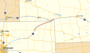
Colorado
U.S. 138 begins in Sterling at U.S. 6 and Business Loop 76. It goes northeast and intersects Colorado State Highway 113 southwest of Iliff. It becomes more easterly as it goes through Iliff, Proctor and Crook, where it intersects Colorado State Highway 55. It continues on to Sedgwick, where it meets Colorado State Highway 59. After passing through Ovid, it then meets U.S. Highway 385 west of Julesburg, and they overlap into Julesburg. Also in Julesburg, U.S. 138 intersects Colorado State Highway 11. U.S. 138 then leaves Julesburg going northeast and enters Nebraska.
Nebraska
Shortly after entering Nebraska, U.S. 138 intersects Interstate 80. It continues east from I-80 and enters Big Springs. At Big Springs, U.S. 138 turns north and ends at U.S. Highway 30.
History
The western terminus is in Sterling, Colorado, where it met U.S. Route 38 from 1926 to 1931 (US 38 became U.S. Route 6); the eastern terminus is at U.S. Route 30 north of Big Springs, Nebraska. US 138 is an example of a "child" route that has long outlived its "parent"; before U.S. Route 99 was decommissioned in 1964, US 138 was the only US route to not have a "parent" route.
Major intersections
| State | County | Location | mi[1][2] | km | Destinations | Notes |
|---|---|---|---|---|---|---|
| Colorado | Logan | Sterling | 0.000 | 0.000 | Western terminus | |
| | 8.970 | 14.436 | ||||
| Crook | 27.503 | 44.262 | ||||
| Sedgwick | Sedgwick | 43.413 | 69.866 | |||
| | 54.810 | 88.208 | West end of US 385 overlap | |||
| Julesburg | 56.956 | 91.662 | ||||
| 58.534 | 94.201 | Interchange; east end of US 385 overlap | ||||
| 59.823 0.00 | 96.276 0.00 | Colorado–Nebraska state line | ||||
| Nebraska | Deuel | | 3.06– 3.51 | 4.92– 5.65 | Interchange; exit 101 on I-80 | |
| Big Springs | 9.44 | 15.19 | ||||
| | 11.47 | 18.46 | Eastern terminus | |||
1.000 mi = 1.609 km; 1.000 km = 0.621 mi
| ||||||
References
- 1 2 "Highway Data Explorer". Colorado Department of Transportation. Retrieved July 20, 2014.
- 1 2 "Nebraska Highway Reference Post Log" (PDF). Nebraska Department of Roads. Retrieved July 20, 2014.
External links
- Colorado Highways: Routes 120 to 139
- The Nebraska Highways Page: Nebraska Highways 101 to 300
- Nebraska Roads: Nebraska US Highways 136-183
| Browse numbered routes | ||||
|---|---|---|---|---|
| ← | CO | SH 139 | ||
| ← | NE | US 159 | ||