Uhabia
| Uhabia | |
|---|---|
 The Uhabia in Bidart | |
| Country | France |
| Basin | |
| Main source | Woods of Ustaritz |
| River mouth |
Bay of Biscay 43°25′56″N 1°35′59″W / 43.43222°N 1.59972°WCoordinates: 43°25′56″N 1°35′59″W / 43.43222°N 1.59972°W |
| Physical characteristics | |
| Length | 15 km (9 mi) |
The Uhabia or Ouhabia is a coastal river of the French Basque Country, in Aquitaine, Southwest France.
Geography
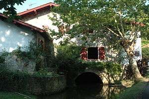
Bidart, the Mill of Bassilour (1741) on the Uhabia

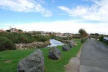
The estuary of the Uhabia
It rises at Goizbide in the woods above Ustaritz and Saint-Pée-sur-Nivelle, where it is known as the Apalagako erreka. It collects waters from the Alhorgako Erreka and drains the plain of Belhardi in the north of Ahetze, before flowing into the Bay of Biscay in Bidart.
Name
Its name Uhabia is the regular evolution of ur habia, that can be translated as "course of the water".
Main tributaries
- Barrandiko Erreka, from Othe xuria,
- Alhorgako Erreka, from Zirikolatz.
Départements and towns
References
External links
| Wikimedia Commons has media related to Uhabia. |
This article is issued from Wikipedia - version of the 7/31/2016. The text is available under the Creative Commons Attribution/Share Alike but additional terms may apply for the media files.