Uncompahgre River
| Uncompahgre River | |
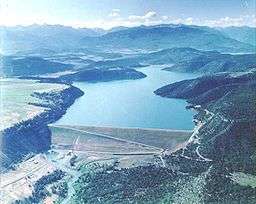 Ridgway Dam and Reservoir on the Uncompahgre River | |
| Country | United States |
|---|---|
| State | Colorado |
| Tributaries | |
| - left | Red Mountain Creek, Canyon Creek (Colorado), Dallas Creek, Dry Creek (Colorado) |
| - right | Cow Creek (Colorado), Cedar Creek (Colorado) |
| Cities | Ouray, Ridgway, Montrose, Olathe, Delta |
| Source | Lake Como |
| - location | near Ouray, San Juan County |
| - elevation | 12,215 ft (3,723 m) |
| - coordinates | 37°55′09″N 107°37′11″W / 37.91917°N 107.61972°W [1] |
| Mouth | Gunnison River |
| - location | Delta, Delta County |
| - elevation | 4,915 ft (1,498 m) |
| - coordinates | 38°45′24″N 108°05′25″W / 38.75667°N 108.09028°WCoordinates: 38°45′24″N 108°05′25″W / 38.75667°N 108.09028°W [1] |
| Length | 75 mi (121 km) [2] |
| Basin | 1,114 sq mi (2,885 km2) [3] |
| Discharge | for Delta, 1.1 mi (1.8 km) from the mouth |
| - average | 304 cu ft/s (9 m3/s) [4] |
| - max | 5,800 cu ft/s (164 m3/s) |
| - min | 15 cu ft/s (0 m3/s) |
The Uncompahgre River is a tributary of the Gunnison River, approximately 75 mi (121 km) long, in southwestern Colorado in the United States. Lake Como at 12,215 ft (3723m) in northern San Juan County, in the Uncompahgre National Forest in the northwestern San Juan Mountains is the headwaters of the river. It flows northwest past Ouray, Ridgway, Montrose, and Olathe and joins the Gunnison at Confluence Park in Delta.
The river forms Poughkeepsie Gulch and the Uncompahgre Gorge. The major tributaries are all creeks draining the northwest San Juan Mountains.
There are two dams on the Uncompahgre River, a small diversion dam in the Uncompahgre Gorge, and Ridgway Dam below the town of Ridgway which forms Ridgway Reservoir.
The river is used for irrigation in the Uncompahgre Valley. Additionally, water from the Gunnison is diverted to the valley via the Gunnison Tunnel. The Uncompahgre is unnavigable except at high water.
The name Uncompahgre (![]() i/ʌnkʌmˈpɑːɡreɪ/) comes from the Ute word Uncompaghre, which loosely translates to "dirty water," "red lake," or "red water spring" and is likely a reference to the many hot springs in the vicinity of Ouray.[5][6]
i/ʌnkʌmˈpɑːɡreɪ/) comes from the Ute word Uncompaghre, which loosely translates to "dirty water," "red lake," or "red water spring" and is likely a reference to the many hot springs in the vicinity of Ouray.[5][6]
See also
References
- 1 2 "Uncompahgre River". Geographic Names Information System. United States Geological Survey. Retrieved 2011-01-27.
- ↑ "USGS National Map Streamer". U.S. Geological Survey. Retrieved 2014-04-20.
- ↑ "Boundary Descriptions and Names of Regions, Subregions, Accounting Units and Cataloging Units". United States Geological Survey. Retrieved 2014-04-20.
- ↑ "USGS Gage #09149500 on the Uncompahgre River at Delta, CO" (PDF). National Water Information System. U.S. Geological Survey. 1939–2013. Retrieved 2014-04-20.
- ↑ Benson, Maxine (1994). 1001 Colorado Place Names. Lawrence: University Press of Kansas. ISBN 0-7006-0632-7.
- ↑ In the journal of Francisco Silvestre Vélez de Escalante's 1776 expedition, the author states that the Native American name for the river was Ancapagari, which translated to Spanish as Laguna Colorado and referred to a hot, bad tasting, red lake from which its waters came. The Spanish name for the river at that time was Rio de San Francisco, apparently so named by explorer Juan Maria de Rivera on one of his two earlier expeditions (1761 and 1765).