Upper Cwmbran
| Upper Cwmbran | |
| Welsh: Cwmbrân Uchaf | |
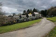 The Square, Upper Cwmbran |
|
 Upper Cwmbran |
|
| Area | 4.74 km2 (1.83 sq mi) [1] |
|---|---|
| Population | 5,228 (2011)[2] |
| – density | 1,103/km2 (2,860/sq mi) |
| OS grid reference | ST 275 965 |
| Community | Upper Cwmbran |
| Principal area | Torfaen |
| Ceremonial county | Gwent |
| Country | Wales |
| Sovereign state | United Kingdom |
| Post town | CWMBRAN |
| Postcode district | NP44 |
| Dialling code | 01633 |
| Police | Gwent |
| Fire | South Wales |
| Ambulance | Welsh |
| EU Parliament | Wales |
| UK Parliament | Torfaen |
| Welsh Assembly | Torfaen |
Coordinates: 51°39′51″N 3°02′50″W / 51.6642°N 3.0472°W
Upper Cwmbran (Welsh: Cwmbrân Uchaf) is a suburb of Cwmbran, Torfaen in Wales. It lies in between the suburbs of Pontnewydd and Thornhill. It is a community and electoral ward of Torfaen County Borough Council.
History & Amenities
The area is mainly made up of 1950s and 1960s houses with occasional older Victorian properties. There are two pubs, The Queen Inn and The Bush Inn, along with a convenience store. The main thoroughfare is Thornhill Road, which eventually becomes Ty Pwca Road as it heads towards Pontnewydd.
Upper Cwmbran was home to the Cwmbran Brewery which closed in December 2009, and a Welsh longhouse called Gelligravog, built in 1610 above The Square. Gelligravog has more recently become a bed and breakfast known as Gelligravog Farmhouse B&B. The Square is a collection of miners' cottages from about 1820.
Notable People
- Ernie Jenkins - a Welsh international dual-code rugby player. Born in Upper Cwmbran, 1880.
- Edwin Thomas Maynard, known as Edwin Thomas or "Beddoe" Thomas, a Welsh international rugby union prop. Born in Upper Cwmbran, 1878, and died in Upper Cwmbran, 1961.
References
- ↑ "2011 Census:Quick Statistics:Population Density for Upper Cwmbran". Office for National Statistics. Retrieved 29 Nov 2013.
- ↑ "2011 Census:Key Statistics:Key Figures for Upper Cwmbran". Office for National Statistics. Retrieved 25 Nov 2013.
External links
| Principal settlements |  | |
|---|---|---|
| Electoral wards | ||
| Communities | ||
| Places of interest | ||
| Rivers and canals | ||
| Topics | ||