Upper Main Street Historic District (Hatfield, Massachusetts)
|
Upper Main Street Historic District | |
|
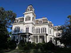
A house on upper Main Street | |
  | |
| Location | Hatfield, Massachusetts |
|---|---|
| Coordinates | 42°23′15″N 72°35′52″W / 42.38750°N 72.59778°WCoordinates: 42°23′15″N 72°35′52″W / 42.38750°N 72.59778°W |
| Architect | Marsh, Hiram; Dickinson, Caleb Cooley |
| Architectural style | Colonial, Mid 19th Century Revival, Late 19th And 20th Century Revivals |
| NRHP Reference # | [1] |
| Added to NRHP | July 22, 1994 |
The Upper Main Street Historic District is a predominantly residential historic district in northeastern Hatfield, Massachusetts. Unlike Hatfield Center, which dated to colonial days and lies south of the district, this part of Hatfield developed roughly between 1860 and 1939 as a village centered on the nearby ferry landing on the Connecticut River. The district includes properties in a roughly triangular area bounded by Main Street, King Street, and North Street, and features a large number of Colonial Revival, Queen Anne, and bungalow-style houses.[2] The district was listed on the National Register of Historic Places in 1994.[1]
See also
- Bradstreet Historic District
- North Hatfield Historic District
- West Hatfield Historic District
- National Register of Historic Places listings in Hampshire County, Massachusetts
References
- 1 2 National Park Service (2008-04-15). "National Register Information System". National Register of Historic Places. National Park Service.
- ↑ "MACRIS inventory record for North-King-Main St.". Commonwealth of Massachusetts. Retrieved 2013-12-19.
| Topics |  | ||||||||||||||||||||||||||||||
|---|---|---|---|---|---|---|---|---|---|---|---|---|---|---|---|---|---|---|---|---|---|---|---|---|---|---|---|---|---|---|---|
| Lists by county | |||||||||||||||||||||||||||||||
| Lists by city |
| ||||||||||||||||||||||||||||||
| Other lists | |||||||||||||||||||||||||||||||
| |||||||||||||||||||||||||||||||
This article is issued from Wikipedia - version of the 11/27/2016. The text is available under the Creative Commons Attribution/Share Alike but additional terms may apply for the media files.