Urho Kekkonen National Park
| Urho Kekkonen National Park (Urho Kekkosen kansallispuisto) | |
| Protected area | |
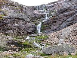 The waterfall in Paratiisikuru (valley), in Urho Kekkonen National Park | |
| Country | Finland |
|---|---|
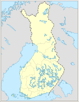
| Region | Lapland |
| Location | Savukoski, Sodankylä, Inari |
| - coordinates | 68°20′N 028°00′E / 68.333°N 28.000°ECoordinates: 68°20′N 028°00′E / 68.333°N 28.000°E |
| Area | 2,550 km2 (985 sq mi) |
| Established | 1983 |
| Management | Metsähallitus |
| Visitation | 289,000 (2009[1]) |
| IUCN category | IV - Habitat/Species government Area |
 | |
| Website: www | |
Urho Kekkonen National Park (Finnish: Urho Kekkosen kansallispuisto) is a national park in Lapland, Finland, situated in area of municipalities of Savukoski, Sodankylä and Inari. Established in 1983 and covering 2,550 square kilometres (985 sq mi), it is one of Finland's largest protected areas. It is named after Urho Kekkonen, late President and Prime Minister of Finland.
The Suomujoki river flows through the northern parts of the diverse park. The marked paths in its western part are an easy destination even for the inexperienced backpacker, whereas the wilderness is good for long and demanding trips.
Most trips to Urho Kekkonen National Park are started from the Kiilopää fell center, the Aittajärvi lake along the Suomujoki river, or Raja-Jooseppi, and backpackers usually end up nearby the Saariselkä fell line, for instance on the top of its highest fell, Sokosti. Reindeer herding is still a common livelihood in the area.
 Trek from Kiilopää in stereoscopic anaglyph
- Trek from Kiilopää in stereoscopic anaglyph
 Trek from Kiilopää in stereoscopic anaglyph

See also
References
- ↑ "Käyntimäärät kansallispuistoittain 2009" (in Finnish). Metsähallitus. Retrieved September 29, 2010.
External links
-
 Media related to Urho Kekkonen National Park at Wikimedia Commons
 -
 Urho Kekkonen National Park travel guide from Wikivoyage
 - Outdoors.fi – Urho Kekkonen National Park
- Visual day-by-day narrative of a trail crossing the national park