Utah State Route 105
| ||||
|---|---|---|---|---|
| Parrish Lane | ||||
 | ||||
| Route information | ||||
| Defined by Utah Code §72-4-116 | ||||
| Maintained by UDOT | ||||
| Length: | 1.111 mi[1] (1.788 km) | |||
| Existed: | 1965[2] – present | |||
| Major junctions | ||||
| West end: |
| |||
| East end: |
| |||
| Highway system | ||||
| ||||

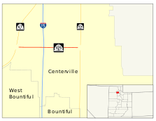
Utah State Route 105 (SR-105) is a state highway in the U.S. state of Utah. It was created in 1965 to serve as a short connector route between Interstate 15 and SR-106 in downtown Centerville. The current route is 1.111 miles (1.788 km) long, after it was extended to the new Legacy Parkway which opened in September 2008.
Route description
Parrish Lane begins at a diamond interchange[3] with Legacy Parkway west of Interstate 15 and becomes SR-105 at a diamond interchange with I-15. SR-105 heads due east passing several local roads before coming to an end at the interchange with SR-106. Parrish Lane continues beyond this interchange, but is no longer part of SR-105.[4]
Traffic on Parrish Lane between I-15 and SR-106 has decreased 17 percent between 2002 and 2007,[5][6] with an average of 16,605 cars per day using Parrish Lane in 2007, compared to 20,000 cars per day in 2002. Eleven percent of the traffic on Parrish Lane is bus and truck traffic.[7]
History
The highway was established in 1965 as a connector from I-15 to SR-106 in Centerville. It remained essentially unchanged until it was extended westward to connect to the newly constructed Legacy Parkway in 2008.[2]
Major intersections
The entire route is in Centerville, Davis County. [8]
| mi[1] | km | Destinations | Notes | ||
|---|---|---|---|---|---|
| 0.000– 0.043 | 0.000– 0.069 | Western terminus | |||
| 0.454– 0.527 | 0.731– 0.848 | ||||
| 0.589 | 0.948 | Frontage Road | |||
| 0.653 | 1.051 | Market Place Drive | |||
| 0.771 | 1.241 | 400 West | |||
| 1.020 | 1.642 | 100 West | |||
| 1.111 | 1.788 | Eastern terminus | |||
| 1.000 mi = 1.609 km; 1.000 km = 0.621 mi | |||||
References
- 1 2 "Highway Reference Route 0105P" (PDF). Utah Department of Transportation. 2008-10-28. Retrieved 2008-12-30.
- 1 2 "Highway Resolutions Route 0105P" (PDF). Utah Department of Transportation. February 2008. Retrieved 2008-12-30.
- ↑ Legacy Parkway Construction Impact Map (PDF) (Map). Utah Department of Transportation. 2007-12-05. Retrieved 2008-08-12.
- ↑ Google (2008-08-12). "Utah State Route 105 Overview" (Map). Google Maps. Google. Retrieved 2008-08-12.
- ↑ "Traffic on Utah Highways 2004" (PDF). Utah Department of Transportation. 2005-12-13. Retrieved 2008-08-18.
- ↑ "Traffic on Utah Highways 2007" (PDF). Utah Department of Transportation. 2008-07-02. Retrieved 2008-08-18.
- ↑ "Truck Traffic on Utah Highways 2007" (PDF). Utah Department of Transportation. 2008-08-18. Retrieved 2008-08-18.
- ↑ Official Utah Highway Map (Map). Utah Department of Transportation. 2007. Wasatch Front inset. Retrieved 2008-09-14.