Utah State Route 48
| ||||
|---|---|---|---|---|
 | ||||
| Route information | ||||
| Defined by Utah Code §72-4-110 | ||||
| Maintained by UDOT | ||||
| Length: | 12.699 mi[1] (20.437 km) | |||
| Existed: | 1927 – present | |||
| Major junctions | ||||
| West end: | Bingham Canyon Mine near Copperton | |||
|
| ||||
| East end: |
| |||
| Highway system | ||||
| ||||

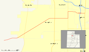
State Route 48 (SR-48) is a highway completely within Salt Lake County in northern Utah that connects the Bingham Canyon Mine with I-15 and US-89. The route is laid on the entirety of the New Bingham Highway and portions of 7800 South, Redwood Road, and 7200 South. When the route was formed in 1927, it passed through the center of Midvale on Center Street. However, it was moved north onto 7200 South in 1965 to serve an exit of I-15.
Route description
The road begins at the gate to the Bingham Canyon Mine and heads northeast as a two-lane undivided highway on the Bingham Highway. The road enters the town of Copperton and turns east. After exiting the town, the Bingham Highway splits into the Old and New Bingham Highway, with SR-48 turning northeast on the latter. The highway enters West Jordan and widens to four lanes past 5600 West. Approaching the Salt Lake City Municipal 2 Airport—a smaller airport for general aviation, in contrast to its larger counterpart—the route turns onto 7800 South and heads east. The road passes Jordan Landing to the south. The route turns north onto a concurrency with SR-68 for eight blocks before turning east onto 7000 South. The route turns southeast, crosses the Jordan River and enters Midvale. The road turns into 7200 South and straightens out to the east. A single-point urban interchange occurs with I-15 at exit 297. The highway continues east three blocks before terminating at US-89.[2]
History
The state legislature added SR-48 to the state highway system in 1927, connecting Bingham with SR-1 (US-91, now US-89) at Midvale Junction.[3] In order to serve the planned I-15 interchange at 7200 South, SR-48 was moved in 1965 to turn north off Center Street onto Holden and Main Streets in Midvale and then east on 7200 South to US-89. As the city of Bingham de-annexed land, a short extension was made at the west end to the new city limits in 1968, but this and more was abandoned in 1973 to allow the Kennecott Copper Corporation to relocate its guard station. An overlap with SR-68 in West Jordan was added in 2000, rerouting SR-48 to turn north at SR-68 and then east on 7000 South to the former alignment at Main Street in Midvale.[4]
Major intersections
The entire route is in Salt Lake County.
| Location | mi[1] | km | Destinations | Notes | |
|---|---|---|---|---|---|
| Copperton | 0.000 | 0.000 | Bingham Canyon Mine | Western terminus | |
| West Jordan | 3.023 | 4.865 | |||
| 8.147 | 13.111 | ||||
| 10.119 | 16.285 | South end of SR-68 overlap | |||
| 10.120 | 16.287 | 7000 South | North end of SR-68 overlap | ||
| Midvale | 11.988 | 19.293 | |||
| 12.699 | 20.437 | Eastern terminus | |||
| 1.000 mi = 1.609 km; 1.000 km = 0.621 mi | |||||
References
- 1 2 "State Route 48 Highway reference". Utah Department of Transportation.
- ↑ "Google Maps". Google.
- ↑ Utah State Legislature (1927). Chapter 21: Designation of State Roads. Session Laws of Utah.
48. From Midvale Junction to Bingham.
- ↑ Utah Department of Transportation, Highway Resolutions: "Route 48". (6.23 MB), updated October 2007, accessed May 2008