Utah State Route 61
| ||||
|---|---|---|---|---|
 | ||||
| Route information | ||||
| Defined by Utah Code §72-4-112 | ||||
| Maintained by UDOT | ||||
| Length: | 7.287 mi[1] (11.727 km) | |||
| Existed: | c. 1937 – present | |||
| Major junctions | ||||
| West end: |
| |||
|
| ||||
| East end: |
| |||
| Highway system | ||||
| ||||

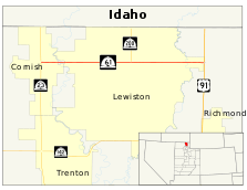
State Route 61 (SR-61) is a nearly 7.3-mile-long (11.7 km) state highway in the U.S. state of Utah, connecting SR-23 in Cornish, Cache County to U.S. Route 91 (US-91) near Richmond via Lewiston, in the extreme northern part of the state. The highway has existed since at least 1914, as SR-61 since at least 1937, and between 735 and 2,180 vehicles travel along the highway on an average day in 2012.
Route description

At the intersection of SR-23 (4800 West) and 13400 North in the center of Cornish, SR-61 departs east on 13400 North due east, crossing over a single track belonging to the Union Pacific Railroad (UP).[1] Exiting Cornish, the highway crosses the Bear River and continues east through rural Cache County. Just shy of the western city limits of Lewiston, the highway intersects SR-200 (800 West), a connector road to Preston, Idaho.[2] From the western terminus to SR-200, the shoulder is up to four feet (1.2 m) wide, suitable for bicycling, however the remainder of the route has much narrower shoulders, between less than or equal to one and nine-tenths feet (0.58 m) wide.[3]
The highway's name changes from 13400 South to Center Street through Lewiston. Passing the Lewiston Cemetery, SR-61 crosses over the Cub River and a second single track belonging to UP, and then a third UP single track just before the highway's eastern terminus at US-91 north of Richmond.[1] All of the rail lines that SR-61 crosses originally belonged to the Oregon Short Line Railway.[4] Aside from the segment through Lewiston, the highway is surrounded by farmland for its entire journey across northern Utah.[2]
Every year, UDOT conducts a series of surveys on its highways in the state to measure traffic volume. This is expressed in terms of average annual daily traffic (AADT), a measure of traffic volume for any average day of the year. In 2012, UDOT calculated that as few as 735 vehicles used the highway on an average day at its western terminus in Cornish, and as many as 2,180 vehicles used the highway at its junction with SR-200.[5] Thirty-five percent of this was truck traffic.[6]
History
A roadway linking Cornish to the east has existed since at least 1914.[4] The roadway that serves as the eastern terminus was numbered SR-1 by 1927,[7] and the highway officially was designated SR-61 since at least 1937.[8] The 53-foot-long (16.2 m) bridge that carries SR-61 over the Cub River today was constructed in 1952,[9] while the 182-foot-long (55.5 m) bridge over the Bear River was built in 1961.[10] The original river crossings were slightly further south than their current locations.[4]
Major intersections
The entire route is in Cache County. [11]
| Location[11] | mi[1] | km | Destinations | Notes | |
|---|---|---|---|---|---|
| Cornish | 0.000 | 0.000 | Western terminus | ||
| | 4.025 | 6.478 | Southern terminus of SR-200 | ||
| | 7.287 | 11.727 | Eastern terminus | ||
| 1.000 mi = 1.609 km; 1.000 km = 0.621 mi | |||||
References
- 1 2 3 4 Staff (August 13, 2013). "State Route 61". Highway Reference. Utah Department of Transportation. Retrieved December 22, 2013.
- 1 2 Google (December 22, 2013). "Utah State Route 61" (Map). Google Maps. Google. Retrieved December 22, 2013.
- ↑ Utah Bicycle Suitability Map (Map). Scale not given. Utah Department of Transportation. Retrieved December 23, 2013.
- 1 2 3 Utah-Idaho: Logan Quadrangle (Map). 1:250,000. Cartography by USGS. United States Geological Survey. 1914. Retrieved December 23, 2013.
- ↑ Staff (2012). Traffic on Utah Highways (PDF) (Report). Utah Department of Transportation. p. 11. Retrieved December 22, 2013.
- ↑ Staff (2012). Truck Traffic on Utah Highways (PDF) (Report). Utah Department of Transportation. p. 11. Retrieved December 22, 2013.
- ↑ Official Paved Road and Commercial Survey of the United States (Map) (1262 ed.). Scale not given. National Map Company. 1927. p. 27. OCLC 767737945. Retrieved December 22, 2013.
- ↑ Texaco Road Map Idaho, Montana, Wyoming (Map). 1:1,774,080. Cartography by Rand McNally. Texaco. 1937. § K-6. Retrieved December 22, 2013.
- ↑ Federal Highway Administration (2012). "NBI Structure Number: 0D 548". National Bridge Inventory. Federal Highway Administration.
- ↑ Federal Highway Administration (2012). "NBI Structure Number: 0F 25". National Bridge Inventory. Federal Highway Administration.
- 1 2 "Cache County" (Map). General Highway Map. 1:22,440. Utah Department of Transportation. 2005. p. 2. Retrieved December 22, 2013.
External links
 Media related to Utah State Route 61 at Wikimedia Commons