Vaksdal (village)
| Vaksdal | |
|---|---|
| Village | |
|
View of the village, looking south | |
 Vaksdal  Vaksdal Location in Hordaland county | |
| Coordinates: 60°28′44″N 05°44′14″E / 60.47889°N 5.73722°ECoordinates: 60°28′44″N 05°44′14″E / 60.47889°N 5.73722°E | |
| Country | Norway |
| Region | Western Norway |
| County | Hordaland |
| District | Nordhordland |
| Municipality | Vaksdal |
| Area[1] | |
| • Total | 0.69 km2 (0.27 sq mi) |
| Elevation[2] | 53 m (174 ft) |
| Population (2013)[1] | |
| • Total | 981 |
| • Density | 1,422/km2 (3,680/sq mi) |
| Time zone | CET (UTC+01:00) |
| • Summer (DST) | CEST (UTC+02:00) |
| Post Code | 5725 Vaksdal |
Vaksdal is a village in Vaksdal municipality in Hordaland county, Norway.[3] The village is located on the southern shore of the Veafjorden, across the fjord from the village of Bruvik which sits on the island of Osterøy. The European route E16 highway goes through the village, as does the Bergensbanen railway line, which stops at the Vaksdal Station. Vaksdal Church was built in the village in 1933. The 0.69-square-kilometre (170-acre) village has a population (2013) of 981, giving the village a population density of 1,422 inhabitants per square kilometre (3,680/sq mi).[1]
Media gallery
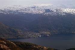
 Vaksdal, looking northeast along the Veafjorden
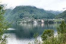 View of the village from across the fjord
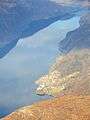
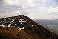 The mountain Bruviknipa, with Vaksdal in the far back right
 The village of Bruvik, with Vaksdal in the back left of the picture
References
- 1 2 3 Statistisk sentralbyrå (1 January 2013). "Urban settlements. Population and area, by municipality.".
- ↑ "Vaksdal" (in Norwegian). yr.no. Retrieved 2014-05-03.
- ↑ Store norske leksikon. "Vaksdal – tettsted" (in Norwegian). Retrieved 2014-05-03.
This article is issued from Wikipedia - version of the 8/4/2016. The text is available under the Creative Commons Attribution/Share Alike but additional terms may apply for the media files.