Valle Stura di Demonte
| Stura di Demonte Valley | |
|---|---|
| Valle Stura di Demonte | |
|
The valley around Sambuco | |
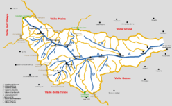 Schematic map of the valley | |
| Location | Piedmont, Italy |
| Floor elevation | 630–3,031 m (2,067–9,944 ft) |
| Long-axis length | around 50 km (31 mi) |
| Geology | |
| Type | glacial and karts valley[1] |
| Geography | |
| Coordinates | 44°19′N 7°10′E / 44.31°N 7.17°ECoordinates: 44°19′N 7°10′E / 44.31°N 7.17°E |

The Stura di Demonte Valley (in Italian Valle Stura di Demonte) is a valley in south-west of Piedmont in the Province of Cuneo, Italy.
Etymology
The valley takes its name from the river Stura di Demonte, a left-hand tributary of the Tanaro which flows through the valley.
Geography
The municipalities of the valley are Aisone, Argentera, Borgo San Dalmazzo, Demonte, Gaiola, Moiola, Pietraporzio, Rittana, Roccasparvera, Sambuco, Valloriate and Vinadio.[2]
Notable summits
Among the notable summits which surround the valley there are:
- Monte Tenibres - 3.031 m
- Cima di Corborant - 3.007 m
- Becco Alto d'Ischiator - 2.996 m
- Testa dell'Ubac - 2.991 m
- Enciastraia - 2.955 m
- Rocca dei Tre Vescovi - 2.867 m
Access
The valley can be reached by car/bus from the Po Plain following the strada statale[3] nr. 21 della Maddalena, which ends with the Colle della Maddalena and connects the Valle Stura di Demonte with the Ubaye Valley (France).
Notes and references
- ↑ Presentazione della Valle Stura di Demonte, Cluudio Trova, web-page on www.vallidicuneo.net (accessed in December 2012)
- ↑ Carta Tecnica Regionale raster 1:10.000 (vers.3.0) of Regione Piemonte - 2007
- ↑ Strada statale = national road
External links
- http://www.vallestura.net/ (Italian)
| Wikimedia Commons has media related to Category:Valle Stura di Demonte. |
This article is issued from Wikipedia - version of the 1/7/2016. The text is available under the Creative Commons Attribution/Share Alike but additional terms may apply for the media files.