Valmy
For other uses, see Valmy (disambiguation).
| Valmy | |
|---|---|
|
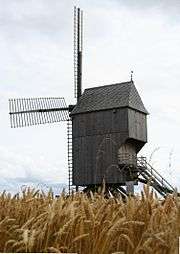
Valmy windmill stands today where the Battle of Valmy took place | |
 Valmy | |
|
Location within Grand Est region  Valmy | |
| Coordinates: 49°05′07″N 4°46′28″E / 49.0853°N 4.7744°ECoordinates: 49°05′07″N 4°46′28″E / 49.0853°N 4.7744°E | |
| Country | France |
| Region | Grand Est |
| Department | Marne |
| Arrondissement | Sainte-Menehould |
| Canton | Sainte-Menehould |
| Area1 | 24.28 km2 (9.37 sq mi) |
| Population (1999)2 | 284 |
| • Density | 12/km2 (30/sq mi) |
| Time zone | CET (UTC+1) |
| • Summer (DST) | CEST (UTC+2) |
| INSEE/Postal code | 51588 / 51800 |
|
1 French Land Register data, which excludes lakes, ponds, glaciers > 1 km² (0.386 sq mi or 247 acres) and river estuaries. 2 Population without double counting: residents of multiple communes (e.g., students and military personnel) only counted once. | |
Valmy is a commune in the Marne department in north-eastern France.
Geography
The town stands on the west flank of the Argonne massif, midway between Verdun and Paris, near Vouziers.
History
- Valmy provided the setting for the Battle of Valmy on 20 September 1792. The largest ship-of-the-line ever constructed, the Valmy, was named after this battle.
See also
External links
| Wikimedia Commons has media related to Valmy. |
This article is issued from Wikipedia - version of the 11/6/2016. The text is available under the Creative Commons Attribution/Share Alike but additional terms may apply for the media files.