Vatersay
| Gaelic name |
|
|---|---|
| Meaning of name | Water island |
 Vatersay Bay | |
| Location | |
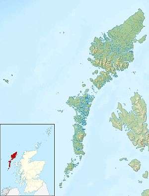 Vatersay Vatersay shown within the Outer Hebrides | |
| OS grid reference | NL635955 |
| Physical geography | |
| Island group | Uist and Barra |
| Area | 960 hectares (3.7 sq mi) |
| Area rank | 51 [1] |
| Highest elevation | Theiseabhal Mòr 190 metres (623 ft) |
| Administration | |
| Sovereign state | United Kingdom |
| Country | Scotland |
| Council area | Comhairle nan Eilean Siar |
| Demographics | |
| Population | 90[2] |
| Population rank | 45= [1] |
| Pop. density | 9.4 people/km2[2][3] |
| Largest settlement | Baile Bhatarsaigh |
| References | [3][4][5] |
Vatersay (Scottish Gaelic: Bhatarsaigh, pronounced [vaʰt̪əɾs̪aj]) is an island in the Outer Hebrides of Scotland. Vatersay is also the name of the only village on the island.
Location
The westernmost permanently inhabited place in Scotland and Great Britain, Vatersay is linked to Barra by a causeway completed in 1991.[6] At low tide, the island is also linked to the islet of Uineasan to the east.
Wildlife
Wildlife on the island includes otters, seals and herons. Bonnie Prince Charlie's flower (Calystegia soldanella), reputedly originating from French seeds dropped by Bonnie Prince Charlie is, in Scotland, found only on Vatersay and Eriskay.
Archaeology
The island has remains of an Iron Age broch at Dun a' Chaolais overlooking the Sound of Vatersay and nearby is a passage grave dated to the 3rd millennium BC.[7] There is also a Bronze Age cemetery at Treasabhaig south of the heights of Theiseabhal Mòr[8] and a cairn built circa 1000 BC west of the village of Vatersay.[9] The offshore islet of Biruaslum has a walled fort that may be of Neolithic provenance.[10]
Wrecks
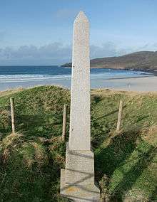
One of the saddest events to befall the island happened when the Annie Jane, a three-masted immigrant ship out of Liverpool bound for Montreal, Canada, struck rocks off West Beach during a storm in September 1853. Within ten minutes the ship began to founder and break up casting 450 people into the raging sea. In spite of the conditions, islanders tried to rescue the passengers and crew.[11]
There were only a few survivors. A small cairn and monument marks the site where the bodies recovered from the sea were buried. An inscription reads:
On 28th September 1853 the ship Annie Jane with emigrants from Liverpool to Quebec was totally wrecked in this bay and threefourths of the crew and passengers numbering about 350 men women and children were drowned and their bodies interred here.
Two Chinese seamen from the SS Idomeneus, which sank on 28 September 1917, are also buried somewhere near the monument. There is a commemorative headstone in Cuier Churchyard.[12]
The remains of a Catalina flying boat that crashed on the slopes of Heishival Beg in 1948 lie in a stream bed near the shore.[13]
Notes
- 1 2 Area and population ranks: there are c. 300 islands over 20 ha in extent and 93 permanently inhabited islands were listed in the 2011 census.
- 1 2 National Records of Scotland (15 August 2013) (pdf) Statistical Bulletin: 2011 Census: First Results on Population and Household Estimates for Scotland - Release 1C (Part Two). "Appendix 2: Population and households on Scotland’s inhabited islands". Retrieved 17 August 2013.
- 1 2 Haswell-Smith, Hamish (2004). The Scottish Islands. Edinburgh: Canongate. ISBN 978-1-84195-454-7.
- ↑ Ordnance Survey. Get-a-map (Map). 1:25,000. Leisure. Ordinance Survey. Retrieved 21 August 2013.
- ↑ Mac an Tàilleir, Iain (2003) Ainmean-àite/Placenames. (pdf) Pàrlamaid na h-Alba. Retrieved 26 August 2012.
- ↑ "Undiscovered Vatersay". Isle of Barra. Archived from the original on 23 September 2008. Retrieved 2008-11-06.
- ↑ Branigan (2007) p. 65
- ↑ Branigan (2007) p. 66
- ↑ Branigan (2007) p. 68
- ↑ Branigan (2007) p. 67
- ↑ "Annie Jane Memorial - the story". Isle of Vatersay. Retrieved 2008-11-06.
- ↑ CWGC Dept of Honour
- ↑ "Consolidated Catalina: Vatersay, Heishival Beg". Canmore. Retrieved 13 Nov 2011.
References
- Branigan, Keith (2007) Ancient Barra: exploring the Archaeology of the Outer Hebrides. Comhairle nan Eilean Siar.
External links
- Panorama of the West Bay on Vatersay (Annie Jane burial cairn and monument) (QuickTime required)
Inhabited islands of the Hebrides | ||
|---|---|---|
| Inner Hebrides | 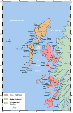 | |
| Outer Hebrides | ||
|  | ||||||||||||||||||||||||||||
|
| |||||||||||||||||||||||||||||
| |||||||||||||||||||||||||||||
| |||||||||||||||||||||||||||||
| |||||||||||||||||||||||||||||
| |||||||||||||||||||||||||||||
| |||||||||||||||||||||||||||||
| |||||||||||||||||||||||||||||
Coordinates: 56°55′41″N 7°32′01″W / 56.92805°N 7.53357°W